
Day four of a seven day hike on the Bibbulmun Track, the walk from Dog Pool to Mt Chance contains some of the worst walking along the entire Bibbulmun Track. With unsealed roads dominating more than half of the days kilometres, the beautiful Pingerup Plains offer some respite from the earlier boring walking. The beautiful campsite at Mt Chance is one of the tracks best however, while Mt Chance itself offers spectacular 360° views
Distance: 19.4 km (one way)
Gradient: Relatively gentle over its entire length, with some minor inclines
Quality of Path: Largely clear and well maintained, although the Pingerup Plains were very overgrown at times. Sections can be inundated through Winter and Spring
Quality of Signage: Largely well signed, with the Waugal providing very clear directional information.
Experience Required: Previous Bushwalking Experience Recommended
Time: 4.5-5.5 Hours
Steps: Some informal steps
Best Time to Visit: All year, except for the peak of Summer and during particularly stormy Winter days.
Entry Fee: No
Getting There: This section was walked hut to hut. Dog Road campsite can be accessed via a relatively short 4.1 kilometres walk from the exclusion gate on Dog Road. Dog Road running east off Deeside Road. Mt Chance can be reached indirectly by walking in from South Coast HwyEntry Fee: No

Since her run in with the Old German Man on the Overland Track last year, Alissa has become extremely self-conscious and paranoid whenever we had to share a hut with other people. Fear that her mattress will be too noisy has often been an overriding a concern, and as such having the huts to ourselves for the first two nights of Northcliffe to Walpole was a great relief. Sharing the hut at Dog Pool with the three older guys was a great lesson then, as we most definitely did not have to worry about being the noisy party in the hut. Two of the three guys were snorers, with one of them being so impressively loud that we could hear him even with earplugs in! With my own snoring adding to the cacophonous chorus, Alissa ended up grabbing her mattress, pillow and sleeping bag and taking it out to sleep on a large log that had been converted into a flat-bottom bench.
Although it had taken me a long time to fall asleep, I had slept through Alissa's move. So you can imagine my complete shock to be woken up by the sound of the three guys getting packed and ready at 4:30am(!) only to find Alissa had disappeared! I was relieved when one of the guys mentioned that someone was sleeping by the fire pit. After the three guys had left before sunrise to avoid the heat in the open plains between Dog Pool and Lake Maringup, Alissa and I got our own preparations under way.

The previous day of walking had ended on a sour note thanks to a dull 5.6 kilometre home stretch along Dog Road, and after crossing the bridge over the river at Dog Pool, Alissa and I were once again following the broad Dog Road.

Our time spent along Dog Road was fairly brief, and although the area had clearly been burnt in the 2015 fires, the morning sun shining through the branches made for a lovely start to the day.

These positive feelings soon subsided as we turned to walk along Marron Road - a broad, sandy road through ugly stunted Jarrah, with little in the way of views or anything of interest.

Dog Road had been bad enough, but Marron Road is a continuous 8.7 kilometres of mind-numbing boredom. Look, I love the Bibbulmun Track, but no one is served by me gushing about every section being amazing when it isn't - I've got to keep it 100 and tell it like it is. I've disliked several sections of the Bibbulmun Track before - some of the swampy areas near Canning Campsite, the unremarkable stretch of track from Powerline Road leading to North Bannister and the continuous maze through regrowth Karri between Beavis and Beedelup huts immediately come to mind - however this is to me the absolute nadir.

I certainly understand that using existing roads makes sense from an economic point of view, however Marron Road reeks of expediency trumping an enjoyable experience. To add insult to injury, the maps shows that Marron Road runs parallel to the Gardner River, with a series of rapids immediately nearby. Just imagine how much more enjoyable this stretch would be if it brought walkers to beautiful river views!

The walking improves further along Marron Road, however by then we'd be along the road for over an hour and the Karri forests were just not as impressive as those we'd seen between Donnelly River Village and Pemberton.

It was a great relief to see Marron Road reach a T-junction, with the orange Bibbulmun mark post indicating a left turn off Marron Road. While having a rest, Alissa and I realised that the sheer boredom had resulted in us absolutely crushing our usual walking speed average. Alissa and I usually aim for a 4 km/h walking speed, slowing to 3.5 km/h if the terrain is a bit more hilly. We covered the 9.7 kilometres to the end of Marron Road is under two hours, resulting in an average pace of 4.85 kilometres! Considering that I stopped a few times to take photos and for Alissa to catch up, I must have been doing over 5 km/h at times - about the pace I usually walk on pavement without a backpack!

If you thought the end of Marron Road was the end of the road walking, think again! We had another 2.9 kilometres to go along Pingerup Road. Although less broad that Marron Road, Pingerup Road features much of the same scenery and sandy walking we had already experienced earlier in the day. The Bibbulmun Track Foundation advertise Northcliffe to Walpole as 'the remotest section of the southern part of the Track, with few roads and almost no signs of civilisation for eight days!' which seems inaccurate given that from the start of Dog Road to the end of Pingerup Rd is a continuous 18.2 kilometres of road bash!

Things did at least improve a little further down Pingerup Road, with taller and denser Jarrah forest becoming more prevalent.

Finally, after 12.6 kilometres along three roads, the Bibbulmun turned off Pingerup Road and into single file, purpose-built walk trail as the track headed into the Pingerup Plains.


Although the track was severely overgrown at times, the Pingerup Plains were a major step up in quality from earlier in the day. Although we had seen several open sections over the last few days, the Pingerup Plains were even more open, with grasslands stretching out far into the distance. Although less amazing than the Button-grass plains on the Overland Track in Tasmania, the Pingerup Plains were beautiful in their own way.
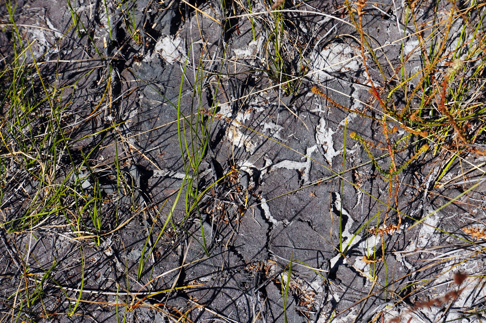
This section of the track is flooded out every year, as evidenced by the cracked ground visible at many points along the plains.

Given the open nature of the grass plains and the lack of shade, Alissa and I appreciated the fact that the track repeatedly entered shaded, forested areas before once again returning to the plains. It showed that some good route planning had gone into creating this stretch of track as it provided a nice balance between open plains and more forested areas.

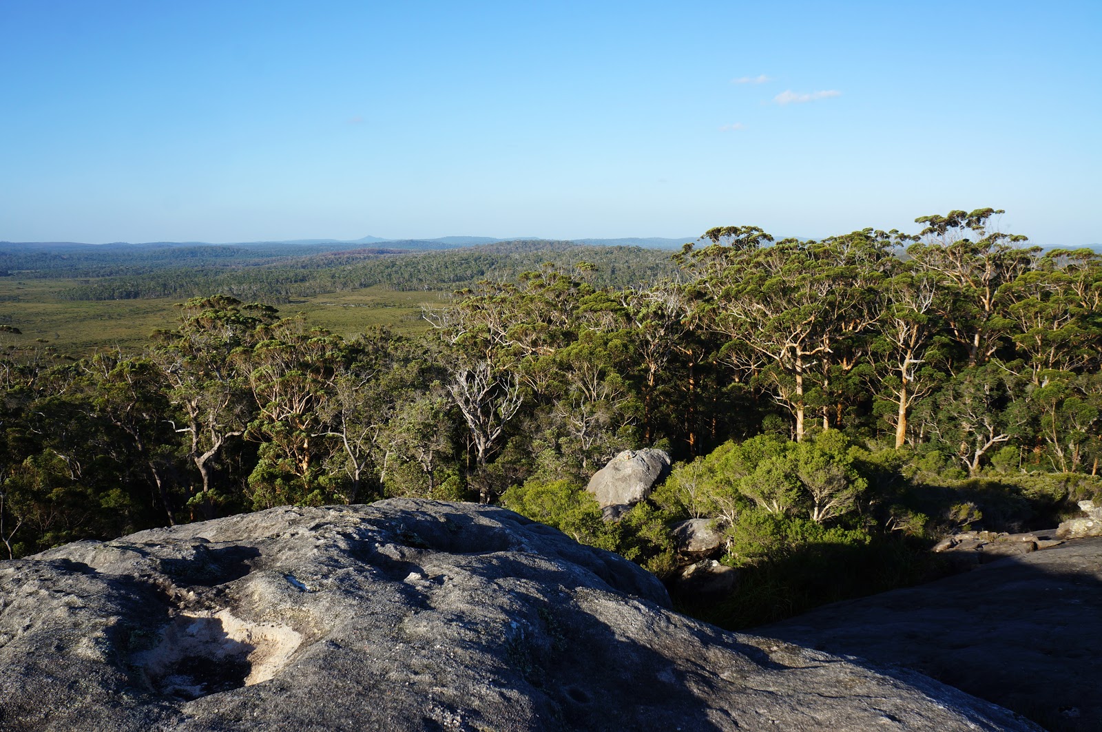
It was interesting to see how Granite seemed to be a major ally of the trees, as Granite outcrops appeared in many of the more forested areas. While doing the Nancy Peak Circuit in the Porongurups, Alissa and I had read that the run off from the rocks supplements the water supply from rain and can sustain populations of Karri in areas that don't actually have enough rainfall. Just beyond the Granite outcrop pictured above was a single Karri tree that had found a way to survive in a sea of Jarrah thanks to the run off provided by the rock.

After walking back and forth between plains and Jarrah forest for several kilometres, Alissa and I caught a glimpse of a large Granite dome peaking out beyond the trees, suggesting we were not far from Mt Chance.

Unfortunately, the track winds itself around the forest for some distance before reaching the turnoff to the hut, and it is then still another 300 metres before walkers reach their destination!

Walkng down the track, Mt Chance is something of a surprise. The forest near the track junction is dominated by Jarrah, however the Jarrah forest slowly gives way to lush Karri trees as the trail approaches the hut. This was the third great hut location in a row, and its reward was much needed after the horrible morning.

After having the campsite to ourselves for a few hours, Alissa and I were joined by a lone hiker who was attempting a Northbound End to End. A lovely American lady and Appalachian Trail Thru-hiker going by the trail name of Kangapard, we immediately got along well with her and were impressed by her homemade backpack and the fact she had the ultralight weight version of our Big Agnes tent!

After resting for a few hours, Alissa and I decided to check out Mt Chance itself, reached by a short trail that starts just by the front of the hut.

More a large batholith than a true mountain, the way to the top of Mt Chance is marked by a series of cairns.

The way up seems impossibly steep, but is actually very achievable thanks to an abundance of grooves that provide shallow steps all the way up, and it can actually be done without using hands to climb. I would not climb this if it was raining however, as its a long slide down to the bottom if you slip!

Alissa was concerned with the steepness and looked for another way up, however decided that the less steep way was far too overgrown for her to be walking through with just a pair of Crocs as footwear. As such, she decided that she wasn't fussed getting to the top.
The views from the summit were definitely worthwhile however. As with the Porongurups, Mt Chance supports a small forest of Karri trees just near where the water would run off, with smaller Jarrah beyond it. I really loved being able to see the Granite of Mt Chance in the foreground, a wall of Karri in the middle and the sweeping Pingerup Plains in the background.

Mt Chance definitely lifted my spirits. After the 12.6 kilometres of road slog at the start of the day, I really needed something amazing like Mt Chance to remind me of how beautiful the Bibbulmun Track - and Western Australia in general - can be.

Nevertheless, the negatives of the day definitely outweighed the positives, and Alissa and I agreed that we were somewhat underwhelmed by this town to town section of the Bibbulmun at this point of the walk - even if we were thoroughly impressed by the hut locations. Mt Chance was the third great hut location in a row, and I would easily say Lake Maringup and Mt Chance are contenders for Top 10 huts on the track. Sadly, it felt like the route of the track itself had been a bit of an afterthought compared to the campsites, and more effort going into the walking experience would have been preferable. For me, hiking is more about the journey than the destination so the focus on great campsites linked by boring walking seems to have got the equation the wrong way around - you might as well be car camping and drive to a fantastic location if that's the way its gonna be. Thankfully, I can say that the walking greatly improved from Mt Chance onwards with our last three days to Walpole being a huge improvement on Dog Road to Pingerup Road - my least favourite 18.6 kilometres of walking along the Bibbulmun Track.


Great story, keep walking
ReplyDelete