

A superb but challenging unmarked and partly off track walk in the Perth Hills, the Wungong Gorge Walk GPS Route explores the ruggedly beautiful Wungong Gorge. Initially climbing up to explore an adjacent gully, the walk rises up both sides of the gorge valley for spectacular views. One of the best walks in the Perth region, this sadly unmarked walk is best undertaken by experienced hikers only.
Distance: 15.5 km (loop)
Gradient: Alternates between relatively easy, gentle gradients and section of very steep difficult terrain, with some scrambling required
Quality of Path: Ranges from well formed vehicle tracks, informal bush pads and completely off-track sections with no obvious path. Several parts of this walk are unmarked and map reading skills are essential. The rocky scrambles would be very slippery after rain - extra caution must be taken.
Quality of Signage: Non-existent; though some flagging tape is present, this walk is an unmarked route and map reading skills are essential. Route information is available from Walk GPS.
Experience Required: Previous Bushwalking Experience Required. This is a navigationally difficult walk that is highly unsuitable for all but experienced hikers who are comfortable with off-track navigation.
Time: 6-8 Hours
Steps: Many informal steps, plus some scrambling required
Best Time to Visit: Late Winter/Mid Spring
Entry Fee: No, however access to the GPS file requires a subscription to Walk GPS.
Entry Fee: No, however access to the GPS file requires a subscription to Walk GPS.
Getting There: The trail starts from a car park at the corner of South Western Hwy and Rails Crescent, north of the main Bungendore Park car park.

The City of Armadale have been recently working hard on a transformative project to realign their tourism strategies under the Perth Hills brand, and I received an email from them asking for my opinion about walk trails in their area. Perusing some of the draft marketing documentation, I came across a feature on something they were calling 'the Mini-Bib' - a 15.5 kilometre Wungong Gorge Walk in Wungong Regional Park. Intrigued, I did a bit of research online and found that it was a route pioneered by Walk GPS - a website of off-track walks in the Perth area that require the use of a GPS to follow waymarkers - and that our friend Mark from the Life of Py had attempted the route last year. Although off track walking is normally something outside our purview, photos of granite ridges and rugged terrain were enough to convince me that we had to see what this walk was all about. Our first attempt at the route was not successful due to our GPS battery running flat, however there was enough of interest for us to return the next weekend to redo the whole thing from start the finish.
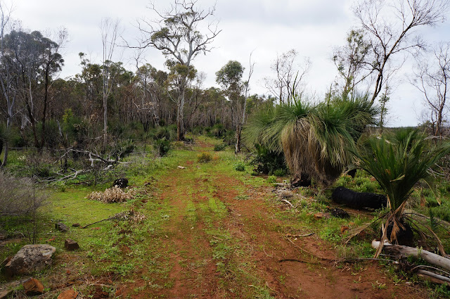
The walk starts from a sandy car park at the corner of South Western Hwy and Rails Crescent. The walk immediately crosses a small stream and then follows a fence before entering an expansive grassy field dotted with some large trees. On our first attempt, this was when we first got the GPS out, as there are a lot of vehicle tracks and informal trails throughout the area. On our second attempt we were much more confident, following a route between several tall trees before reaching the start of an informal single file walk/cycle trail weaving through a slope dominated by grass trees.

The area had been badly burnt by fire earlier in the year, and while some of the trees along the slope have not recovered, it looks like the vast majority of the massive Grass Trees has managed to survive. Something to look out for during this stretch of the track is that parts of the route are marked with flagging tape. These are particularly helpful along the stretches when the walking goes off-track, however it should be noted that there is also some flag tape in place for other routes. If this is your first time doing the route, it is best to check the KML file to ensure you are going the right way.

After some off-track walking, the route continues along an old vehicle track, providing some of our first views of the steep-sided hills on either side of Wungong Gorge. As a fan of rugged walking, the views filled me with anticipation and the hope that we would get a chance to work our way around some of the granite outcrops and boulders.

The trail makes a sharp turn left and ascends a mildly eroded vehicle track as it leads to the top of a ridge.
At the top of the climb, another piece of flagging tape tied to a tree signifies a 90° turn, with the route following a more informal vehicle track. On our second visit, we ran into a couple of mountain bike riders following some informal trails to the left of the vehicle track, revealing that this area is also a popular mountain bike riding location.

The route suggests making another right turn before reaching a fence line, however Alissa and I were unable to find this presumably overgrown road. We instead reached the fence line, turned right and continued along until we reached a gate preventing vehicle access to the next section of the track.

On our first attempt, Alissa and I ended up continuing along the road looking for more flagging tape only to find that we'd completely overshot the point where the route heads off track. On our second attempt, we were able to identify it immediately at a bend in the road, with Alissa pointing out that the dead white tree to the left of the photo above can be seen in the Google Earth image. Up until this point, the off track sections have been quite straightforward as a bushwalking pad has formed, however there really is no trail at this point, so walkers need to be comfortable with reading a GPS as well as using a compass to ensure that you're walking in the correct direction. On our first attempt, we were only using Google Earth to identify our location and found that it is not overly accurate in displaying your location, which resulted in us veering off course on numerous occasions. On our second attempt, we learnt our lesson and used a compass to ensure that we stayed on course towards the next GPS waypoint.

Making our way through the scratchy scrub, the route reaches a granite outcrop near a grassy clearing. I can see why the creator of the route picked this location as the area is really lovely, made all the more special as it looks like the area miraculously survived the fire without getting burnt.

There are a number of indistinct goat trails cutting across the landscape, so it is again worth using a compass to make your way to the next waypoint immediately east of the first granite outcrop, passing through flowering heath and several Christmas Trees.

On our first attempt, we veered too far south and had to double back to reach the new waypoint, however by keeping more directly westward, we were able to find the right path very easily. An even larger granite outcrop, this is another excellent landmark for walkers to use as a navigational guide with the track running immediately in front of it and descending westwards down the escarpment. The route downhill is not overly clear as there are a number of goat trails and impossibly steep informal bike tracks, however walkers need to simply continue westwards until they join a distinct vehicle track heading south.

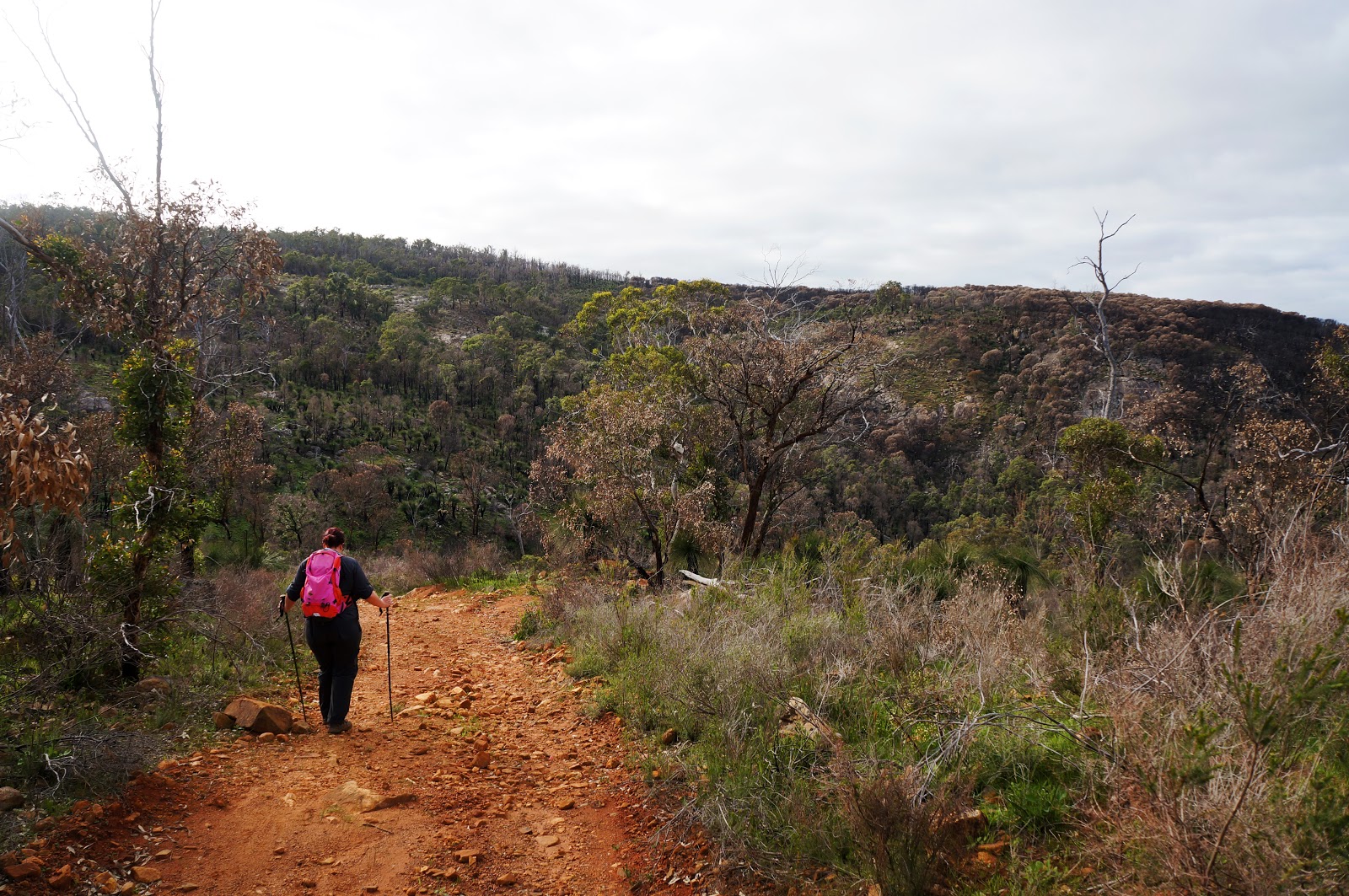
The area on either side of the vehicle track is quite badly burnt, making it a bit less engaging than it would have been before the fires went through, however the clearer understorey provided us an opportunity to admire a particularly impressive granite outcrop to the right of the track and a gentle stream flowing to the left.

The vehicle track reaches a T-junction were it joins the family friendly Wungong Gorge Walk Trail that links Bungendore Park to Wungong Dam. This old road running alongside Wungong Brook is very popular with locals, and is the only part of the walk where we encountered a lot of other people out and about. If you're a fan of dogs, this is a perfect place for dog watching.

Along the trail are a number of landmarks worth checking out. One is an old granite quarry and the rusting remnants of an old ramp which can be reached via a side trail. More impressive is an gauging station along the brook that runs alongside a rather impressive granite outcrop. The Walk GPS route suggests going along the brook, and we dutifully followed the route on our first attempt. We found that the trail did not seem to link back onto the main vehicle track and we had to bush bash our way back onto the track. On our second attempt, we decided to treat the gauging station as a side trip and simply returned back to the track as we continued our way eastwards.

Again, the burnt out trees were not as impressive as they would have been before the fire, however Alissa and I were quite amazed by the size of the gorge and the massive domes of solid granite. While there is a lot of granite in the Perth Hills, we don't usually get massive walls of continuous granite so much as smaller outcrops. Although the area lacked Karri trees, Alissa and I felt that the area bore a strong resemblance to the Porongurups, especially the views across the valley on the Nancy Peak Circuit to the Devil's Slide.

Further along the Walk GPS route branches off the Wungong Gorge Trail for the walk's second ascent. The walk rises steeply up another old vehicle track. Walking the trail in early Spring, we were treated to an almost continuous tunnel of yellow wattle flowers all the way up.

Waiting for Alissa at the top of the ascent, I noticed a side trail running off into the bushes towards a natural rocky lookout point and decided to investigate. The view from the top of the rocks was excellent, with great views across to the other side of the valley. To the east I could just make out the wall of Wungong Dam.

The walk continued along the obvious vehicle track. Just after passing a very small dam, the walk turns right at a T-junction before passing through the distinctive gate pictured above.
Just beyond the gate, walkers should see an old concrete water tank to the right of the track. Continuing along the trail with the tank at your 5 o'clock, the route goes off into the bushes. The turn off is not overly obvious if you were just passing by, but it is relatively easy to follow once you know what you're looking for. The trail eventually runs underneath some powerlines which walks briefly follow.

The route turns off from the powerlines at a very overgrown road that seems to end and then veers to the left via a less obvious goat trail. On our first attempt, we followed the goat trail and found that it lead no where, resulting in us having to bush bash to get back on track. For our second attempt we decided to instead push on straight ahead and use our compass to point us in the correct direction instead of trying to find a bushwalking pad. My strong advice for this section is to use your compass to guide your direction as it is the best way to ensure you are still following the route.

Looking straight ahead at the overgrown road, we were again slightly skeptical that this was the right way to go.

Pressing on with compass in hand, we had a bit of a laugh as after about 10-20 metres of overgrown scrub, we were on a very obvious and easy to follow vehicle track. There are a number of cross roads and trails that intersect the vehicle track and it is really important to follow the GPS and compass very carefully to ensure you take the correct turn off.

Back onto vehicle tracks, Alissa and I were happy to see some flag tape tied to trees at various intersections, making navigation easy once again.

On our first attempt, Alissa and I continued walking along the vehicle track looking for more flag tape, and we ended up heading down a very steep, eroded slope. We joked about how crappy it would be if we had taken the wrong turn and had to go back up the steep slope. Alissa checked the GPS and revealed that we had indeed taken the wrong turn and would have to climb back up. To make matters worse, once Alissa and I were back on track we stopped to check the GPS and compass right on top of an ant nest and were promptly attacked! On our second attempt, we used the ant nest as a landmark for the start of the next off track section.

Again using our compass to follow the direction of the route, Alissa and I passed through an area dominated by massive Grass Trees that had thankfully not been burnt by the fires earlier in the year. Along this stretch, there is no obvious bushwalking pad for the first part of the descent however it eventually joins a mildly eroded trail that runs down to a clearing at the bottom of the descent.

Emerging out of the forest, Alissa and I were gifted with lovely views across the valley before following another old vehicle track down back to the Wungong Gorge Walk Trail.

Once at the bottom of the descent, the route turns right to head back westwards along Wungong Gorge. This area was apparently a farm/homestead property a long time ago, and there are some attractive introduced trees and fields of wood sorrel that provide a lovely pastoral scene. Walking along the trail, there was section with a tree growing to the right with gnarled roots holding it some distance above the level of the track. I joked that this was a perfect place to hide from Nazgul due to the area's similarity to a famous scene from Lord of the Rings, and Alissa pointed out that Mark from Life of Py had also found the area to have a Shire-like appearance when he did the walk.

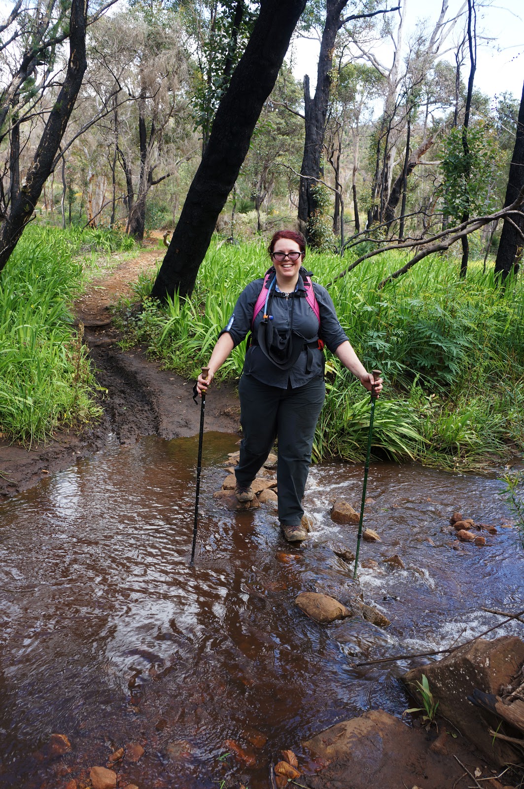
Keeping an eye on the GPS, Alissa identified the correct crossing point for us to make our way to the other side of the brook. Following more vehicle tracks, the walk passes by a number of lovely granite outrcrops as the trails snakes its way up the valley.

On our first attempt, we had to pull out at this point as our GPS died and we were not confident in continuing on. We agreed this was definitely the right decision when we made our way through this area on our second attempt as this was easily the hardest part of the walk from a navigational point of view, and I must stress that anyone who is not confident with reading a GPS, map and compass should not continue on through this section. Being burnt out, there was no obvious trail at all along this stretch, and we found that we didn't descend quite as far down as the route suggested we should. We ended up walking straight along the valley slope until we were back on track right before what ended up being one of the best stretches of the whole walk.

The route runs up a steep granite outcrop that could be potentially dangerous in wet weather, but was relatively easy for us to clamber up. I love this kind of rugged terrain for walking, and I was absolutely in my element - I truly wish more walks in Perth had this kind of exciting terrain to walk through.

Up the top of the outcrop, Alissa and I were gifted with spectacular views across the valley. For me, the views from this part of the walk made all the navigational challenges worthwhile as it is easily some of the best rugged walking in the Perth region.

Continuing along the route, Alissa and I reached a jumble of granite boulders. While the fire had burnt many of the trees along the edge of the boulders, a single Grass Tree improbably growing in a crack of a large outcrop had somehow survived unscathed.

Alissa and I had intended to continue westwards along the ridge, however we reach a sheer granite cliff that forced us to have to head up the valley.

Climbing up the top of the granite boulders, we stopped briefly to take in the spectacular valley views before continuing in a south west direction to rejoin the vehicle trail.

Back on the vehicle track, Alissa and I were relieved to not have to be continually referencing a compass and GPS for a while. At a fork in the road, Alissa and I thought that we would take the right turn down the valley as it looked to be heading back to the start of the walk, howevert consulting the map showed that we would be turning left instead. This seemed strange as it looked like an unnecessarily long way round.

The wisdom of this diversion became clear as the track led to an excellent lookout point filled with rock cairns, including the particularly elaborate example above. Less impressive was evidence of discarded spray cans, beer bottles and dirt bike tracks from previous visitors who didn't subscribe to Leave No Trace principles.

After the lookout, Alissa and I continued again along the route. Looking at the satellite imagery, the route seemed to go off track just to cut a corner, while a somewhat clear vehicle track seemed to cut straight through to the other side. Alissa and I decided to forge our own path and chose to follow the clear vehicle track instead. As we came to a dead end on the road, Alissa and I realised why the area looked like a clear path in the satellite image - it became a steep descent down a rocky gully! With our options being to either continue down the gully's gorge or walk back up the hill, Alissa and I decided to press on as we could see the vehicle track we needed to get to the other side of the valley.

This was a particularly steep descent, and I would not recommend it if you're not confident with picking a route through rocky terrain. If you enjoy route finding in a rugged landscape, than this is a very fun 'shortcut'. Although we did not know it at the time, I would later discover that this was the same gully explored by Mark and Aron from Life of Py, and was the fateful location where Mark dropped his phone and damaged it.

Once at the bottom of the descent, the gully takes a sharp turn right. At this point, we reached an old vehicle track that joined back onto the main track on the other side of the gully. The vehicle track provided one last spectacular view of Wungong Gorge before descending back down to join the Wungong Gorge Walk Trial.
Just before reaching the Wungong Gorge Walk Trail, the route crosses the brook via a series of stepping stones.

The Walk GPS route suggests to follow a walk trail right along the brook, however by this stage Alissa and I were ready to put the map and GPS away and instead followed the main walk trail with all the locals taking their dogs out for a walk. This trail continues onwards to the main car park at Bungendore Park. Just before reaching the car park, we rejoined the Walk GPS route as it turns right along a vehicle track that leads back to the start of the walk, thus completing the circuit.

Heading out for this walk with its considerable off track sections, Alissa and I did not know what to expect and whether or not the 'Mini-Bib' designation was an oversell. In terms of scenery I can definitely see the comparison as it has a very similar look to the Darling Scarp sections of the track, and I would go as far as to say that it is even more impressive and ruggedly beautiful than the the vast majority of the track north of Canning campsite. Alissa and I could not believe how beautiful and rugged the area was, and the fact there is no serious marked trail in this area seems very surprising. A formalised and marked version of this route would easily be in my Top 5 trails in Perth, and although it lacks waterfalls, I concur with Mark's assessment that it would outclass the Eagle View Walk Trail.
The fact it is not marked and formalised is a real shame, and it is this aspect of the trail that makes the 'Mini-Bib' designation perhaps problematic. Casual walkers used to the user friendliness of the the Bibbulmun might be shocked by how much navigation is required for this unmarked route, and I would suggest it is only suitable for experienced walkers with solid navigation skills. As experienced walkers, Alissa and I were able to follow the route fairly closely, and even then we made quite a few wrong turns! Given the dearth of challenging and scenic walk trails in Perth that are over 10 kilometres long, it is a bit of a shame that this walk is only readily accessible to a select few, and it was even more disappointing to find that the Walk GPS page has put this route behind a paywall in the interim between our first attempt and our successful completion of the walk, thus making it even more inaccessible. I know the area is earmarked by cycling peak bodies for a potential cycle trail network, but this is such a solidly impressive walk that I really hope the City of Armadale seriously consider formalising the route into a marked trail because they have a real winner on their hands. For now, if you have the suitable skills and experience to complete an off-track walk, we can thoroughly recommend the Wungong Gorge Walk GPS Route as one of the best walk experiences in the Perth region.

The City of Armadale have been recently working hard on a transformative project to realign their tourism strategies under the Perth Hills brand, and I received an email from them asking for my opinion about walk trails in their area. Perusing some of the draft marketing documentation, I came across a feature on something they were calling 'the Mini-Bib' - a 15.5 kilometre Wungong Gorge Walk in Wungong Regional Park. Intrigued, I did a bit of research online and found that it was a route pioneered by Walk GPS - a website of off-track walks in the Perth area that require the use of a GPS to follow waymarkers - and that our friend Mark from the Life of Py had attempted the route last year. Although off track walking is normally something outside our purview, photos of granite ridges and rugged terrain were enough to convince me that we had to see what this walk was all about. Our first attempt at the route was not successful due to our GPS battery running flat, however there was enough of interest for us to return the next weekend to redo the whole thing from start the finish.
The walk starts from a sandy car park at the corner of South Western Hwy and Rails Crescent. The walk immediately crosses a small stream and then follows a fence before entering an expansive grassy field dotted with some large trees. On our first attempt, this was when we first got the GPS out, as there are a lot of vehicle tracks and informal trails throughout the area. On our second attempt we were much more confident, following a route between several tall trees before reaching the start of an informal single file walk/cycle trail weaving through a slope dominated by grass trees.

The area had been badly burnt by fire earlier in the year, and while some of the trees along the slope have not recovered, it looks like the vast majority of the massive Grass Trees has managed to survive. Something to look out for during this stretch of the track is that parts of the route are marked with flagging tape. These are particularly helpful along the stretches when the walking goes off-track, however it should be noted that there is also some flag tape in place for other routes. If this is your first time doing the route, it is best to check the KML file to ensure you are going the right way.
After some off-track walking, the route continues along an old vehicle track, providing some of our first views of the steep-sided hills on either side of Wungong Gorge. As a fan of rugged walking, the views filled me with anticipation and the hope that we would get a chance to work our way around some of the granite outcrops and boulders.

The trail makes a sharp turn left and ascends a mildly eroded vehicle track as it leads to the top of a ridge.

At the top of the climb, another piece of flagging tape tied to a tree signifies a 90° turn, with the route following a more informal vehicle track. On our second visit, we ran into a couple of mountain bike riders following some informal trails to the left of the vehicle track, revealing that this area is also a popular mountain bike riding location.

The route suggests making another right turn before reaching a fence line, however Alissa and I were unable to find this presumably overgrown road. We instead reached the fence line, turned right and continued along until we reached a gate preventing vehicle access to the next section of the track.

On our first attempt, Alissa and I ended up continuing along the road looking for more flagging tape only to find that we'd completely overshot the point where the route heads off track. On our second attempt, we were able to identify it immediately at a bend in the road, with Alissa pointing out that the dead white tree to the left of the photo above can be seen in the Google Earth image. Up until this point, the off track sections have been quite straightforward as a bushwalking pad has formed, however there really is no trail at this point, so walkers need to be comfortable with reading a GPS as well as using a compass to ensure that you're walking in the correct direction. On our first attempt, we were only using Google Earth to identify our location and found that it is not overly accurate in displaying your location, which resulted in us veering off course on numerous occasions. On our second attempt, we learnt our lesson and used a compass to ensure that we stayed on course towards the next GPS waypoint.

Making our way through the scratchy scrub, the route reaches a granite outcrop near a grassy clearing. I can see why the creator of the route picked this location as the area is really lovely, made all the more special as it looks like the area miraculously survived the fire without getting burnt.

There are a number of indistinct goat trails cutting across the landscape, so it is again worth using a compass to make your way to the next waypoint immediately east of the first granite outcrop, passing through flowering heath and several Christmas Trees.

On our first attempt, we veered too far south and had to double back to reach the new waypoint, however by keeping more directly westward, we were able to find the right path very easily. An even larger granite outcrop, this is another excellent landmark for walkers to use as a navigational guide with the track running immediately in front of it and descending westwards down the escarpment. The route downhill is not overly clear as there are a number of goat trails and impossibly steep informal bike tracks, however walkers need to simply continue westwards until they join a distinct vehicle track heading south.

The area on either side of the vehicle track is quite badly burnt, making it a bit less engaging than it would have been before the fires went through, however the clearer understorey provided us an opportunity to admire a particularly impressive granite outcrop to the right of the track and a gentle stream flowing to the left.

The vehicle track reaches a T-junction were it joins the family friendly Wungong Gorge Walk Trail that links Bungendore Park to Wungong Dam. This old road running alongside Wungong Brook is very popular with locals, and is the only part of the walk where we encountered a lot of other people out and about. If you're a fan of dogs, this is a perfect place for dog watching.

Along the trail are a number of landmarks worth checking out. One is an old granite quarry and the rusting remnants of an old ramp which can be reached via a side trail. More impressive is an gauging station along the brook that runs alongside a rather impressive granite outcrop. The Walk GPS route suggests going along the brook, and we dutifully followed the route on our first attempt. We found that the trail did not seem to link back onto the main vehicle track and we had to bush bash our way back onto the track. On our second attempt, we decided to treat the gauging station as a side trip and simply returned back to the track as we continued our way eastwards.

Again, the burnt out trees were not as impressive as they would have been before the fire, however Alissa and I were quite amazed by the size of the gorge and the massive domes of solid granite. While there is a lot of granite in the Perth Hills, we don't usually get massive walls of continuous granite so much as smaller outcrops. Although the area lacked Karri trees, Alissa and I felt that the area bore a strong resemblance to the Porongurups, especially the views across the valley on the Nancy Peak Circuit to the Devil's Slide.

Further along the Walk GPS route branches off the Wungong Gorge Trail for the walk's second ascent. The walk rises steeply up another old vehicle track. Walking the trail in early Spring, we were treated to an almost continuous tunnel of yellow wattle flowers all the way up.

Waiting for Alissa at the top of the ascent, I noticed a side trail running off into the bushes towards a natural rocky lookout point and decided to investigate. The view from the top of the rocks was excellent, with great views across to the other side of the valley. To the east I could just make out the wall of Wungong Dam.

The walk continued along the obvious vehicle track. Just after passing a very small dam, the walk turns right at a T-junction before passing through the distinctive gate pictured above.
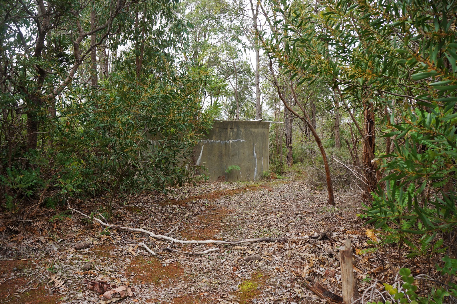
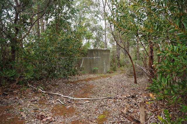
Just beyond the gate, walkers should see an old concrete water tank to the right of the track. Continuing along the trail with the tank at your 5 o'clock, the route goes off into the bushes. The turn off is not overly obvious if you were just passing by, but it is relatively easy to follow once you know what you're looking for. The trail eventually runs underneath some powerlines which walks briefly follow.

The route turns off from the powerlines at a very overgrown road that seems to end and then veers to the left via a less obvious goat trail. On our first attempt, we followed the goat trail and found that it lead no where, resulting in us having to bush bash to get back on track. For our second attempt we decided to instead push on straight ahead and use our compass to point us in the correct direction instead of trying to find a bushwalking pad. My strong advice for this section is to use your compass to guide your direction as it is the best way to ensure you are still following the route.

Looking straight ahead at the overgrown road, we were again slightly skeptical that this was the right way to go.

Pressing on with compass in hand, we had a bit of a laugh as after about 10-20 metres of overgrown scrub, we were on a very obvious and easy to follow vehicle track. There are a number of cross roads and trails that intersect the vehicle track and it is really important to follow the GPS and compass very carefully to ensure you take the correct turn off.

Back onto vehicle tracks, Alissa and I were happy to see some flag tape tied to trees at various intersections, making navigation easy once again.

On our first attempt, Alissa and I continued walking along the vehicle track looking for more flag tape, and we ended up heading down a very steep, eroded slope. We joked about how crappy it would be if we had taken the wrong turn and had to go back up the steep slope. Alissa checked the GPS and revealed that we had indeed taken the wrong turn and would have to climb back up. To make matters worse, once Alissa and I were back on track we stopped to check the GPS and compass right on top of an ant nest and were promptly attacked! On our second attempt, we used the ant nest as a landmark for the start of the next off track section.

Again using our compass to follow the direction of the route, Alissa and I passed through an area dominated by massive Grass Trees that had thankfully not been burnt by the fires earlier in the year. Along this stretch, there is no obvious bushwalking pad for the first part of the descent however it eventually joins a mildly eroded trail that runs down to a clearing at the bottom of the descent.

Emerging out of the forest, Alissa and I were gifted with lovely views across the valley before following another old vehicle track down back to the Wungong Gorge Walk Trail.

Once at the bottom of the descent, the route turns right to head back westwards along Wungong Gorge. This area was apparently a farm/homestead property a long time ago, and there are some attractive introduced trees and fields of wood sorrel that provide a lovely pastoral scene. Walking along the trail, there was section with a tree growing to the right with gnarled roots holding it some distance above the level of the track. I joked that this was a perfect place to hide from Nazgul due to the area's similarity to a famous scene from Lord of the Rings, and Alissa pointed out that Mark from Life of Py had also found the area to have a Shire-like appearance when he did the walk.

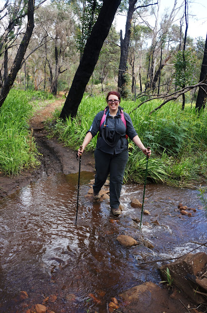
Keeping an eye on the GPS, Alissa identified the correct crossing point for us to make our way to the other side of the brook. Following more vehicle tracks, the walk passes by a number of lovely granite outrcrops as the trails snakes its way up the valley.

On our first attempt, we had to pull out at this point as our GPS died and we were not confident in continuing on. We agreed this was definitely the right decision when we made our way through this area on our second attempt as this was easily the hardest part of the walk from a navigational point of view, and I must stress that anyone who is not confident with reading a GPS, map and compass should not continue on through this section. Being burnt out, there was no obvious trail at all along this stretch, and we found that we didn't descend quite as far down as the route suggested we should. We ended up walking straight along the valley slope until we were back on track right before what ended up being one of the best stretches of the whole walk.

The route runs up a steep granite outcrop that could be potentially dangerous in wet weather, but was relatively easy for us to clamber up. I love this kind of rugged terrain for walking, and I was absolutely in my element - I truly wish more walks in Perth had this kind of exciting terrain to walk through.

Up the top of the outcrop, Alissa and I were gifted with spectacular views across the valley. For me, the views from this part of the walk made all the navigational challenges worthwhile as it is easily some of the best rugged walking in the Perth region.

Continuing along the route, Alissa and I reached a jumble of granite boulders. While the fire had burnt many of the trees along the edge of the boulders, a single Grass Tree improbably growing in a crack of a large outcrop had somehow survived unscathed.

Alissa and I had intended to continue westwards along the ridge, however we reach a sheer granite cliff that forced us to have to head up the valley.

Climbing up the top of the granite boulders, we stopped briefly to take in the spectacular valley views before continuing in a south west direction to rejoin the vehicle trail.

Back on the vehicle track, Alissa and I were relieved to not have to be continually referencing a compass and GPS for a while. At a fork in the road, Alissa and I thought that we would take the right turn down the valley as it looked to be heading back to the start of the walk, howevert consulting the map showed that we would be turning left instead. This seemed strange as it looked like an unnecessarily long way round.

The wisdom of this diversion became clear as the track led to an excellent lookout point filled with rock cairns, including the particularly elaborate example above. Less impressive was evidence of discarded spray cans, beer bottles and dirt bike tracks from previous visitors who didn't subscribe to Leave No Trace principles.

After the lookout, Alissa and I continued again along the route. Looking at the satellite imagery, the route seemed to go off track just to cut a corner, while a somewhat clear vehicle track seemed to cut straight through to the other side. Alissa and I decided to forge our own path and chose to follow the clear vehicle track instead. As we came to a dead end on the road, Alissa and I realised why the area looked like a clear path in the satellite image - it became a steep descent down a rocky gully! With our options being to either continue down the gully's gorge or walk back up the hill, Alissa and I decided to press on as we could see the vehicle track we needed to get to the other side of the valley.

This was a particularly steep descent, and I would not recommend it if you're not confident with picking a route through rocky terrain. If you enjoy route finding in a rugged landscape, than this is a very fun 'shortcut'. Although we did not know it at the time, I would later discover that this was the same gully explored by Mark and Aron from Life of Py, and was the fateful location where Mark dropped his phone and damaged it.

Once at the bottom of the descent, the gully takes a sharp turn right. At this point, we reached an old vehicle track that joined back onto the main track on the other side of the gully. The vehicle track provided one last spectacular view of Wungong Gorge before descending back down to join the Wungong Gorge Walk Trial.
Just before reaching the Wungong Gorge Walk Trail, the route crosses the brook via a series of stepping stones.

The Walk GPS route suggests to follow a walk trail right along the brook, however by this stage Alissa and I were ready to put the map and GPS away and instead followed the main walk trail with all the locals taking their dogs out for a walk. This trail continues onwards to the main car park at Bungendore Park. Just before reaching the car park, we rejoined the Walk GPS route as it turns right along a vehicle track that leads back to the start of the walk, thus completing the circuit.

Heading out for this walk with its considerable off track sections, Alissa and I did not know what to expect and whether or not the 'Mini-Bib' designation was an oversell. In terms of scenery I can definitely see the comparison as it has a very similar look to the Darling Scarp sections of the track, and I would go as far as to say that it is even more impressive and ruggedly beautiful than the the vast majority of the track north of Canning campsite. Alissa and I could not believe how beautiful and rugged the area was, and the fact there is no serious marked trail in this area seems very surprising. A formalised and marked version of this route would easily be in my Top 5 trails in Perth, and although it lacks waterfalls, I concur with Mark's assessment that it would outclass the Eagle View Walk Trail.
The fact it is not marked and formalised is a real shame, and it is this aspect of the trail that makes the 'Mini-Bib' designation perhaps problematic. Casual walkers used to the user friendliness of the the Bibbulmun might be shocked by how much navigation is required for this unmarked route, and I would suggest it is only suitable for experienced walkers with solid navigation skills. As experienced walkers, Alissa and I were able to follow the route fairly closely, and even then we made quite a few wrong turns! Given the dearth of challenging and scenic walk trails in Perth that are over 10 kilometres long, it is a bit of a shame that this walk is only readily accessible to a select few, and it was even more disappointing to find that the Walk GPS page has put this route behind a paywall in the interim between our first attempt and our successful completion of the walk, thus making it even more inaccessible. I know the area is earmarked by cycling peak bodies for a potential cycle trail network, but this is such a solidly impressive walk that I really hope the City of Armadale seriously consider formalising the route into a marked trail because they have a real winner on their hands. For now, if you have the suitable skills and experience to complete an off-track walk, we can thoroughly recommend the Wungong Gorge Walk GPS Route as one of the best walk experiences in the Perth region.


0 comments:
Post a Comment