

Day five of a seven day thru-hike of the Cape to Cape Track, Contos to Hamelin Bay features a sustained section of inland walking. Initially taking in the beautiful Peppermint Trees of Point Rd, the track passes through the spectacular Karri-dominated Boranup Forest. Heading to the coast via Boranup Hill Lookout, a surprisingly enjoyable 9 kilometre beach walk leads to the idyllic beachside locality of Hamelin Bay. A unique and different day along the Cape to Cape.
Distance: 22.5 km (one way)
Gradient: Some moderate descents and ascents throughout the length of the walk, with some moderate inclines between Hooley Rd and Boranup Beach
Quality of Path: Largely clear and well maintained. Some uneven sections with rocky limestone surfaces.
Quality of Signage: Largely well signed, with the the Cape to Cape Track markers allowing walkers to remain on track (albeit lacking in directional information).
Experience Required: Previous Bushwalking Experience Recommended
Time: 5.5 Hours, including a few rest break along the beach
Steps: Some steps at the lookout and at the Hamelin Bay beach exit
Best Time to Visit: Late Autumn/Early Spring
Entry Fee: No
Getting There: Contos Campground can be reached from Conto Rd, which also runs off Caves Rd. Hamelin Bay can be reached via Hamelin Bay Rd West. At a sharp t-junction on Caves Rd, Caves Rd becomes Hamelin Bay Rd West. Entry Fee: No

Although some light drizzle fell early in the evening, Alissa and I woke up after a good night's sleep at Contos to a dry tent - a welcome change of fortunes after having to roll it up wet at Moses Rock two days earlier. Even more welcome was the good news that Alissa's back was feeling a lot better than it had the previous morning, which meant she would definitely be continuing on with the walk. After using the luxury of the outdoor kitchen shelter to eat breakfast, roll out the tent on a concrete surface (rather than the sand) and pack our bags, Alissa and I were on our way for one the most unique days of the Cape to Cape Track.
Walking through Contos and back to the track, it was not initially clear which way we should go to continue southwards, however we had noted the direction Allan and Adrian had walked the previous day and were able to find the linking trail back onto the Cape to Cape. Walking down a steep hill, we could see sections of forest in the distance that had obviously been burnt in recent prescribed burns. Before starting the walk, I had received notice that there was a deviation in place due to the burns, however the work had either been completed early or the rains had postponed the deviations as we ended up walking the official Cape to Cape Track route the entire day.

Only 1.5 kilometres into the day's walking, Alissa and I reached Point Rd Campsite. This is where Allan and Adrian had chosen to camp instead of Contos, and is considerably more low key than the deluxe facilities of Contos as it lacks water tanks and camp kitchens.

Point Rd makes up for the lack of facilities by being a really beautiful spot to camp, with large, mature Peppermint trees making for a shady and idyllic campsite.

After a quick chat with Allan and Adrian, Alissa and I continued on our way. A mere 250 metres from the campsite, Alissa and I were gifted with our first spectacular view of the Boranup Karri Forest. Having stopped to check out the forest on many occasions while driving down Caves Rd, this had been the part of the walk that Alissa had been most excited about, and she was particularly glad that her back had not played up as it meant getting to walk this lovely section of the track.

This glimpse of the Karri forest was surprisingly brief however, and we turned off Point Rd to follow a vehicle track through somewhat more ordinary Jarrah, Marri and Peppermint forest. While less exciting, the Grass Trees along this stretch were impressively tall and we noticed a very targeted methodology to the prescribed burns whereby the Grass Trees were the only trees burnt rather than the indiscriminate scorched earth approach favoured by Parks and Wildlife closer to Perth.

While the more targeted burning was better than the badly burnt Jarrah forest that had predominated a lot of our Bibbulmun Track walking towards the end of our sectional End to End, I was beginning to fear that the 50 metres of Karri forest walking on Point Rd was all we were going to get. As we turned onto Davies Rd I was relieved to find the track once again enter a section of beautiful Karri forest mixed with occasional patches of old growth Marri and Jarrah.

This was a superb stretch of forest walking, and the prevalence of Karri trees reminded us of the good times we had walking from Donnelly River Village to Pemberton on the Bibbulmun Track. During this stretch, Allan and Adrian caught up to us and we briefly walked together for a time. The photo above is unfortunately the only photo we have of them, and as they were pushing on through Hamelin Bay to Deepdene we would not see them again for the rest of our walk.

We waved goodbye to Allan and Adrian when we stumbled upon a photo opportunity we could not pass up - a photo of me at my namesake road!

Donovan Rd was 1.5 kilometres along Davies Road, and one kilometre later we turned right onto Hooley Rd, which becomes Trig Rd. Walking uphill on Trig Rd, Alissa and I left the Karri forest stretch of the track as we made our way through lower Jarrah, Marri and Bullich forest.

The walking along Trig Rd was probably the most boring stretch of walking of the entire Cape to Cape Track, and even the targeted burns didn't help make this any more exciting. Alissa and I talked a fair bit about this dull Bibbulmun Track-like stretch of walking along old vehicle tracks and agreed that it was the price to pay for taking us through the Boranup Forest, but that the benefits of including the beautiful Karri forest greatly outweighed the negatives of this boring stretch of walking.

One of the more interesting aspects of walking along Trig Rd was seeing how Parks and Wildlife manage their burning program in the area. In addition to the fires being well targeted to only burn Grass Trees, they also had signs indicating that certain parcels of forest were not to be burnt. Upon seeing these signs, I quipped that I'd love to put a few of these up in the virgin Jarrah forest near Yourdamung given that we witnessed a few of these old growth trees cut down due to the roots being burnt out.
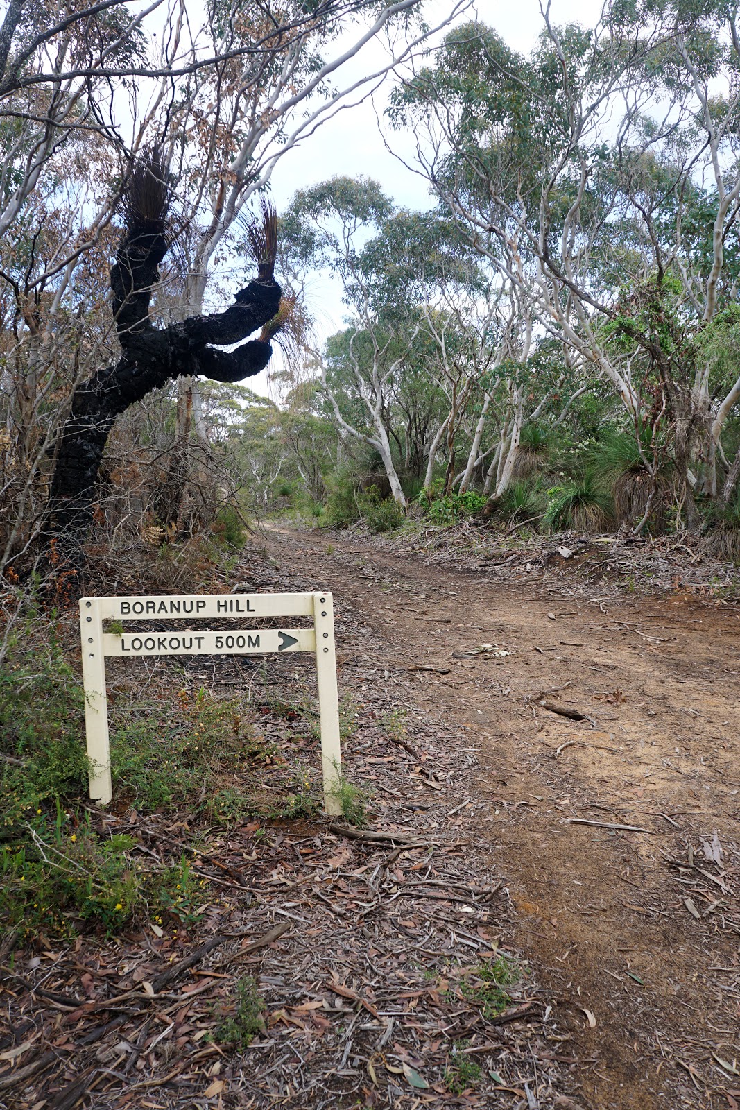
Almost 4 kilometres into Trig Rd, the Cape to Cape Track reaches the junction to the Boranup Hill lookout. Strangely enough, the Boranup Hill Lookout is not treated as an optional side trip the way visiting Sugarloaf Rock, Canal Rocks or Quininup Falls are, and instead actually counts towards the overall kilometres of the Cape to Cape Track! This seems like a weird practice to me, and I bet that there would be a sizeable percentage of Cape to Cape Track hikers who skip the short return journey to the lookout.

But of course since the Long Way's Better, I decided to take the side trip and check out the views from Boranup Hill. The walk to the lookout is a fairly easy amble along a vehicle track lined with Bullich and Peppermint Trees. The guidebook suggests that the climb to the top is steep, however this is only for the last 50 metres and would probably rate as moderately easy in the mountain/hill walking scheme of things.

Made from treated pine posts, the lookout is a very simply structure, and there is a fair bit of clear ground surrounding the lookout and tucked into the bushes that indicates that it is sometimes used by stealth campers. Indeed, John Chapman's suggested itinerary has Contos to Boranup Hill listed as the fifth day of walking even though there are no facilities at the site beyond the lookout.

The views from the lookout are okay but not overly memorable. While you get to see the forest surrounding the area and glimpses of the ocean, the whole side trip to Boranup Hill seemed to be little more than filler in my opinion, and determined hikers looking to give it a miss wouldn't really be missing out on much.

Back on the main track, the Cape to Cape continues on Trig Rd for some distance before eventually returning to single file walking track as it reaches Boranup Beach.

As we approached the beach, we could see Hamelin Island and White Cliff Point in the distance. With our goal in sight, we prepared ourselves mentally for the 9 kilometres of beach walking ahead of us.

Descending through the dunes, Alissa and I took off our shoes. My foot pain had returned by the end of Trig Rd, and walking bare foot on the sand was a nice relief.

The walk along Boranup Beach started well enough, with the sand being relatively firm under foot. While it became softer towards the middle of the bay, the initial firmness helped give us a good head start, and we set a cracking pace for the first three kilometres.

What appears to be a long, featureless beach on paper ended up being quite an interesting and enjoyable walk. Shelves of flat rock could be seen submerged just beneath the water at various points along the walk, with small rock pools dotted throughout.

One of my favourite moments walking along Boranup Beach was provided by a wooden packing crate that constantly danced on the ebb and flow of the waves lapping on the shore. Being slightly in front of Alissa, I stopped to watch the crate's mesmerising show for a little while. The photo above does not do justice to the experience, and I'm kicking myself somewhat for not filming it given its American Beauty-like quality.

After the soft sand of the middle third of the walk, the last third had a completely different character, with rocky shelves along the beach and piles of seaweed making walking a bit of a maze. The waves had made the rocks fairly smooth, and we ended up leaving our shoes off as we walked along the rocky shelves and waded through the small pools.

After just over two hours of walking, Alissa and I made it to the famous ruins of Hamelin Bay's Jetty. The jetty had been used by the timber industry in the 19th Century but has long been abandoned and deteriorated. The few pylons that remain are now being maintained by Parks and Wildlife as an iconic landmark along this beautiful beach.
The other famous icons of Hamelin Bay are the friendly and inquisitive stingrays that visit the area, swimming right up to people at the shore. The somewhat cold and cloudy weather unfortunately meant that none were out on the day we visited, but Hamelin Bay is such a beautiful area we'd happily come back to check out the stingrays over the Summer.

Unlike Yallingup, Gracetown and Prevelly, Hamelin Bay is not an actual town, with the only thing in the area being the Hamelin Bay Holiday Park. There is a kiosk and general store within the Holiday Park, and Alissa and I were happy to forego our usual Le Snak and Tuna to Go lunch and have a pie instead!

We had originally booked a tent site at Hamelin Bay, however due to Alissa's back we decided to upgrade to one of the powered cabins and sleep in a real bed instead. This proved to be an excellent choice as the upgrade was not particularly expensive and we enjoyed the luxury of lying in a comfortable bed and watching television. I have to say I went into the Cape to Cape with a bit of a purist attitude of not staying in towns and getting as much of a wilderness experience as possible, but I came to really enjoy the fact that we were able to have a shower and sleep in a proper bed every other day.
Although the somewhat grey weather on the day may make it appear like this was a bit of a dull day, Alissa and I really enjoyed Contos to Hamelin Bay. Although the stretch from Dooley Rd to Boranup Beach was not overly exciting, the beautiful forests from Contos through to Davies Rd were highlights of the entire trip, and the long walk along Boranup Beach was surprisingly enjoyable as far as beach walking goes. Hamelin Bay itself was probably our favourite part of the day, and we enjoyed the Holiday Park so much that we'd happily come back. With less of the epic granite formations seen earlier along the Cape to Cape, I wasn't sure how the later days were going to be. I'm glad to say that this was another enjoyable day of walking that left Alissa and I continually impressed by what the Cape to Cape had to offer.


0 comments:
Post a Comment