

Aptly described as 'short but uncompromising', the trek to Talyuberlup's peak is one of the more difficult in the Stirling Range. Tackling the mountain head on, the trail is a continual and increasingly steep ascent that requires scrambling in its latter half. Walkers are rewarded with an impressive mountain cave and views of tall, rocky crags on the way to the summit, as well as views across the range - if you are lucky with the weather!
Distance: 2.6 km (return)
Gradient: Continually uphill, with some very steep sections requiring free hands for scrambling.
Quality of Path: Relatively clear and straightforward. Some of the lower sections have suffered from erosion, making the trail more difficult. The rockier scramble sections can be very slippery - extra caution must be taken.
Quality of Signage: Good and informative trailhead, but little signage along the way. The path is easy to discern however, and wooden pegs have been put in place to guide walkers in the more confusing areas.
Experience Required: Previous Bushwalking Experience Required. This is a very hard walk in steep and potentially dangerous terrain known for its unpredictable weather, with large sections of the walk requiring scrambling. Highly unsuitable for beginners or those with known knee problems
Time: 2-3 Hours
Steps: Some steps earlier on, as well as sections requiring scrambling
Best Time to Visit: Autumn and Spring, and milder Winter days
Entry Fee: No
Entry Fee: No
Getting There: Access to Talyuberlup is via Stirling Range Dr, which turns off west from Chester Pass Rd. Talyuberlup is the signed mountain along the road heading west.

With my sights set on climbing Toolbrunup Peak before my 30th birthday, I've been doing a lot of research on the other mountain walks in Stirling Range National Park. With Toolbrunup rated as significantly more difficult than the taller and more famous Bluff Knoll, I was keen to get a feel for the kind of technical walking Toolbrunup entails in a smaller, more manageable size. Although the shortest of the six mountains open to tourists, the 783 metre-tall Talyberlup Peak is rated as a difficult, Class 5 walk by DPaW. After seeing photos of the mountain's rocky summit and seeing it described as 'short but uncompromising', Talyuberlup Peak sounded like just the ticket. Watching the weather all week to ensure it was all clear, we headed down on Friday night to stay with Alissa's parents in Denmark so we could tackle this challenging walk first thing on Saturday morning.

Starting on Stirling Range Dr, the trail's car park is located on the south side of the road while the trailhead is located immediately north. To begin with, the trail follows a gentle ascent through the thin scrappy Talyuberlup Mallee and and Veronica's Wattle that are characteristic of the Stirling Range lowlands.
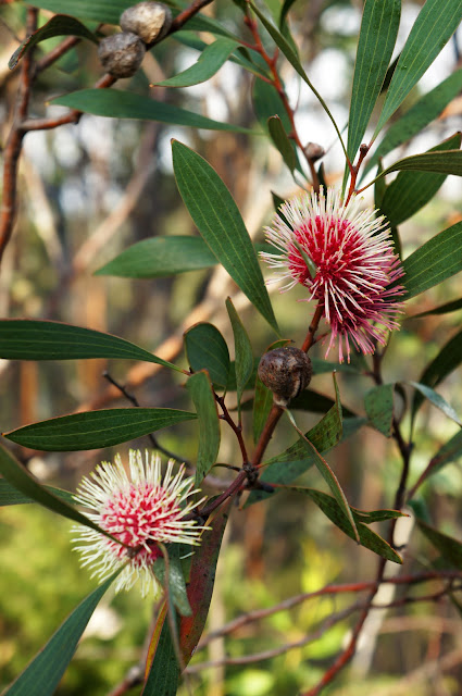
Even in Autumn, Alissa and I were impressed to find flowers in bloom as well as many species of plants we had never encountered before. Although we've walked a small lookout trail along Stirling Range Dr, this was our first proper trek in the Stirlings and it was amazing to see the Range's famed diversity in action.


After clearing the scrappy trees near the start, the mountain became the dominant feature - or at least it would have been had it not been increasingly obscured by mist. The Aboriginal name for the Stirling Range is Koi Kyenunu-ruff, which translates to 'mist moving around the mountains', and there could not be a more apt name for our experience doing this walk.

One of the major challenges early on in this walk is the severe erosion damage that has occurred to the track. Washed away by the frequently wet conditions, this only added to the challenge. I immediately regretted accidentally leaving my trekking poles at home, as did Alissa who actually had her wooden stick in the car but decided to not use it! Many of the trees alongside the trail showed wear from people's hands having used them as supports in the climb.

After the severity of the washed out sections, it was actually a real pleasure to encounter the first rocky section of the track as it was decidedly easier walking. It may not be clear in this photo, but wooden white pegs with painted white tops provide useful way markers in these sections.

At the top of the first rocky section is an overhang that provides a bit of shelter. With Alissa having slowed in pace due to the constant ascent, I probably would have waited for her here if the weather had been rainy but I decided to press on a bit further.

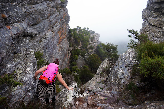
Beyond the overhang, the track skirts an imposingly tall crag. At this point the track goes from being a steep walk to a full on scramble, and I decided to wait for Alissa so we could tackle this more hazardous section together. By now we were well and truly engulfed in mist, with limited visibility beyond a few metres.

This section definitely required free hands and was far more technical walking than we usually undertake, with some of the rocks being somewhat slippery and sometimes requiring a bit of thought to pick the safest route. That being said, the more cautious pace meant that this section was less of a cardio workout than the previous section had been.

After clearing the scramble, we arrived at Talyuberlup's slowly collapsing cave. Although the Trailhead said that we should not enter the cave, it is not 100% clear that it is the indeed the cave, and a wooden peg marker in the cave suggests that straight through is the correct path to take. After going through, I realised where I was and advised Alissa to take the side path instead given she was already a bit unsettled by the earlier scramble.

Through to the other side, the cave's tunnel-like structure is much more obvious.

From the cave, the mountain opens up to an clear clifftop, with the trail leading down and then up past some impressive rocky spires to the summit via another steep scramble.


The rocks up here were covered in orange speckles (presumably lichen), and made the area look similar to the mountain peaks often pictured in Tasmania.

The summit cairn was large, and had a nestlike shape. As I stood on the summit, the mists began to dissipate, with the Sun gloriously lighting the summit cairn as if on cue!
Satisfied with having made it all the way to the top, Alissa and I began our descent with visibility slowly improving.

As we got down form the top, the clearer views allowed us to better see Talyuberlup's rocky spires. The gap to the right of the taller spire pictured above is where we climbed up to reach the summit.

The shorter spire is arguably the most commonly photographed of Talyuberlup's features, and definitely stands out as the most obvious landmark.
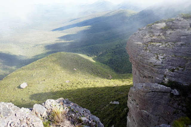
The clearer views also allowed us to see just how high up we were, with the rolling green heathland below offering a nice contrast against Talyuberlup's rugged beauty.

We also got a better look at the cave and could see that it was indeed slowly collapsing. With the track going around the cave to the right of what is pictured above, one has to wonder if it would really be any better to be walking around the cave at the very moment this formation collapsed.


On our walk down the mountain, our regret that were not carrying sticks only intensified as we negotiated slippery rocks and felt the strain on our knees. The views of the surrounding wilderness provided some consolation - a truly beautiful sight.

Talyuberlup Peak is definitely a very hard walk, featuring some of the most difficult terrain on a walk we have written up to date - it makes Bald Head Walk Trail's terrain seem easy in comparison. We took 3 hours to cover the 2.6 kilometre return trip, although we spent roughly half an hour taking photos on and near the summit, and Alissa needed some time to overcome her occasional fear of heights in the first scramble section. Realistically, this could be walked in two hours, and even then the paltry average speed of 1.3 km/h should give some indication of just how challenging this walk is. Alissa and I agreed however that the challenge is entirely worth it, as the rocky terrain of the mountain's peak makes this a walk of truly rugged beauty that is very rare in Western Australia. As with Bald Head Walk Trail, I would actively discourage anyone with little to no bushwalking experience from attempting Talyuberlup Peak, but experienced bushwalkers will definitely find a lot to like about this short but intense walk in the Stirling Range.

As we drove back to Chester Pass Rd, mighty Toolbrunup loomed ahead, seemingly calling to us. Tired and ready to do something else, Toolbrunup would have to wait. With ANZAC Day weekend coming up, Alissa and I will be back to tackle this mountain soon enough. And if Talyberlup is any indication, we are in for a challenging treat.

With my sights set on climbing Toolbrunup Peak before my 30th birthday, I've been doing a lot of research on the other mountain walks in Stirling Range National Park. With Toolbrunup rated as significantly more difficult than the taller and more famous Bluff Knoll, I was keen to get a feel for the kind of technical walking Toolbrunup entails in a smaller, more manageable size. Although the shortest of the six mountains open to tourists, the 783 metre-tall Talyberlup Peak is rated as a difficult, Class 5 walk by DPaW. After seeing photos of the mountain's rocky summit and seeing it described as 'short but uncompromising', Talyuberlup Peak sounded like just the ticket. Watching the weather all week to ensure it was all clear, we headed down on Friday night to stay with Alissa's parents in Denmark so we could tackle this challenging walk first thing on Saturday morning.

Starting on Stirling Range Dr, the trail's car park is located on the south side of the road while the trailhead is located immediately north. To begin with, the trail follows a gentle ascent through the thin scrappy Talyuberlup Mallee and and Veronica's Wattle that are characteristic of the Stirling Range lowlands.

Even in Autumn, Alissa and I were impressed to find flowers in bloom as well as many species of plants we had never encountered before. Although we've walked a small lookout trail along Stirling Range Dr, this was our first proper trek in the Stirlings and it was amazing to see the Range's famed diversity in action.


After clearing the scrappy trees near the start, the mountain became the dominant feature - or at least it would have been had it not been increasingly obscured by mist. The Aboriginal name for the Stirling Range is Koi Kyenunu-ruff, which translates to 'mist moving around the mountains', and there could not be a more apt name for our experience doing this walk.

One of the major challenges early on in this walk is the severe erosion damage that has occurred to the track. Washed away by the frequently wet conditions, this only added to the challenge. I immediately regretted accidentally leaving my trekking poles at home, as did Alissa who actually had her wooden stick in the car but decided to not use it! Many of the trees alongside the trail showed wear from people's hands having used them as supports in the climb.

After the severity of the washed out sections, it was actually a real pleasure to encounter the first rocky section of the track as it was decidedly easier walking. It may not be clear in this photo, but wooden white pegs with painted white tops provide useful way markers in these sections.

At the top of the first rocky section is an overhang that provides a bit of shelter. With Alissa having slowed in pace due to the constant ascent, I probably would have waited for her here if the weather had been rainy but I decided to press on a bit further.

Beyond the overhang, the track skirts an imposingly tall crag. At this point the track goes from being a steep walk to a full on scramble, and I decided to wait for Alissa so we could tackle this more hazardous section together. By now we were well and truly engulfed in mist, with limited visibility beyond a few metres.

This section definitely required free hands and was far more technical walking than we usually undertake, with some of the rocks being somewhat slippery and sometimes requiring a bit of thought to pick the safest route. That being said, the more cautious pace meant that this section was less of a cardio workout than the previous section had been.

After clearing the scramble, we arrived at Talyuberlup's slowly collapsing cave. Although the Trailhead said that we should not enter the cave, it is not 100% clear that it is the indeed the cave, and a wooden peg marker in the cave suggests that straight through is the correct path to take. After going through, I realised where I was and advised Alissa to take the side path instead given she was already a bit unsettled by the earlier scramble.

Through to the other side, the cave's tunnel-like structure is much more obvious.

From the cave, the mountain opens up to an clear clifftop, with the trail leading down and then up past some impressive rocky spires to the summit via another steep scramble.


The rocks up here were covered in orange speckles (presumably lichen), and made the area look similar to the mountain peaks often pictured in Tasmania.

The summit cairn was large, and had a nestlike shape. As I stood on the summit, the mists began to dissipate, with the Sun gloriously lighting the summit cairn as if on cue!
Satisfied with having made it all the way to the top, Alissa and I began our descent with visibility slowly improving.

As we got down form the top, the clearer views allowed us to better see Talyuberlup's rocky spires. The gap to the right of the taller spire pictured above is where we climbed up to reach the summit.

The shorter spire is arguably the most commonly photographed of Talyuberlup's features, and definitely stands out as the most obvious landmark.

The clearer views also allowed us to see just how high up we were, with the rolling green heathland below offering a nice contrast against Talyuberlup's rugged beauty.

We also got a better look at the cave and could see that it was indeed slowly collapsing. With the track going around the cave to the right of what is pictured above, one has to wonder if it would really be any better to be walking around the cave at the very moment this formation collapsed.


On our walk down the mountain, our regret that were not carrying sticks only intensified as we negotiated slippery rocks and felt the strain on our knees. The views of the surrounding wilderness provided some consolation - a truly beautiful sight.

Talyuberlup Peak is definitely a very hard walk, featuring some of the most difficult terrain on a walk we have written up to date - it makes Bald Head Walk Trail's terrain seem easy in comparison. We took 3 hours to cover the 2.6 kilometre return trip, although we spent roughly half an hour taking photos on and near the summit, and Alissa needed some time to overcome her occasional fear of heights in the first scramble section. Realistically, this could be walked in two hours, and even then the paltry average speed of 1.3 km/h should give some indication of just how challenging this walk is. Alissa and I agreed however that the challenge is entirely worth it, as the rocky terrain of the mountain's peak makes this a walk of truly rugged beauty that is very rare in Western Australia. As with Bald Head Walk Trail, I would actively discourage anyone with little to no bushwalking experience from attempting Talyuberlup Peak, but experienced bushwalkers will definitely find a lot to like about this short but intense walk in the Stirling Range.
* * * * *
Postscript

As we drove back to Chester Pass Rd, mighty Toolbrunup loomed ahead, seemingly calling to us. Tired and ready to do something else, Toolbrunup would have to wait. With ANZAC Day weekend coming up, Alissa and I will be back to tackle this mountain soon enough. And if Talyberlup is any indication, we are in for a challenging treat.


0 comments:
Post a Comment