

A relatively easy sectional day walk on the Bibbulmun Track, this mostly flat walk leads from the little known access point on Marginata Rd to Brookton Hwy. The large rock formation known as Abyssinia Rock is the highlight of this section that otherwise passes through a somewhat dull, low-lying swampy area and scrappy Jarrah woodland. One of the least essential sections of the track - its easiness is its main draw.
Distance: 14.6 km (one way)
Gradient: Relatively flat to Abyssinia Rock. The short side trip up Abyssinia Rock is of a fairly gentle gradient. The Ascent to Brookton Hwy is the main incline but is relatively gentle apart from a few short steep sections
Quality of Path: Generally clear and well maintained, although recent bushfires may have impacted on the legibility of the track.
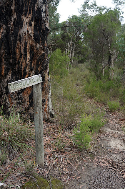
Quality of Signage: Well signed, with the Waugal providing very clear directional information. Again, fire may have impacted on this.
Experience Required: While relatively easy, the fact that this area has recently been burnt may result in unexpected hazards or lack of clarity in the path. As such, Bushwalking experience is recommended.
Time: 4 Hours
Steps: Some steps ascending to Brookton Hwy
Best Time to Visit: Late Winter/Early Spring
Entry Fee: No
Entry Fee: No
Getting There: The Marginata Rd access point is not the easiest to find, and I have written a separate guide for finding this access point. Read the guide here. The Brookton Hwy access point is easily identified, located under the huge pylons of Powerline Rd.

Having set out to do this walk a month earlier and taking the wrong turn, Alissa and I were pleased to be able to find the correct turn off for Four Ways Rd from Marginata Rd and got ourselves onto the Bibbulmun Track with very little difficulty. The walk in from Four Ways Rd and the first few kilometres of walking are pleasant if not overly exciting Jarrah forest, with a fallen, upside-down Jarrah being the most interesting features of this section.
The Jarrah forest clears to an area that is fairly low-lying and swampy, and looks to be the kind of place to be seasonally inundated in late Winter after significant rains.

Duck boards are used intermittently in this section to assist walkers in getting through potentially muddy areas. During our walk in late June, this area was not particularly wet yet, and we encountered no flooding or muddiness issues.

Walking to Canning Campsite was not a particularly long distance. The campsite is in a relatively open space, and yet this campsite just barely survived being burnt by bushfire in January 2016. Being relatively dull even then, I can imagine this area being even less inviting now. Indeed, the Bibbulmun Track Foundation have done as far as to suggest walking other sections of the track for the time being.

Beyond the hut, the track intersected with some old vehicle tracks, and we were disappointed to read in the hut's log book that people are illegally driving on these closed tracks. We witnessed a car driving through here ourselves. It is disheartening to see people willfully ignoring the rules and potentially spreading Dieback in at risk areas - particularly likely given the moistness of the swampy soils. There are a number of cleaning stations along the track - please ensure that you use them.


The highlight of the day is Abyssinia Rock. Walkers heading north towards Brookton Hwy will encounter the smaller, first half of the rock first, however beyond a thin line of shrubbery is the main expanse. Ephemeral Gnamma pools cover the mossy rock, and its overall appearance is similar to the larger and more impressive Sullivan Rock.


The walk up the rock is a relatively easy and worthwhile ascent - this is the best part of this section, and its best to savour it.

Beyond Sullivan Rock is another boot cleaning station, after which the track ascends to Brookton Hwy. The scrappiness of the forest allow for views of the hills and small mountains beyond, and I can imagine walkers heading South would be filled with anticipation for the Canning to Monadnocks section to come.
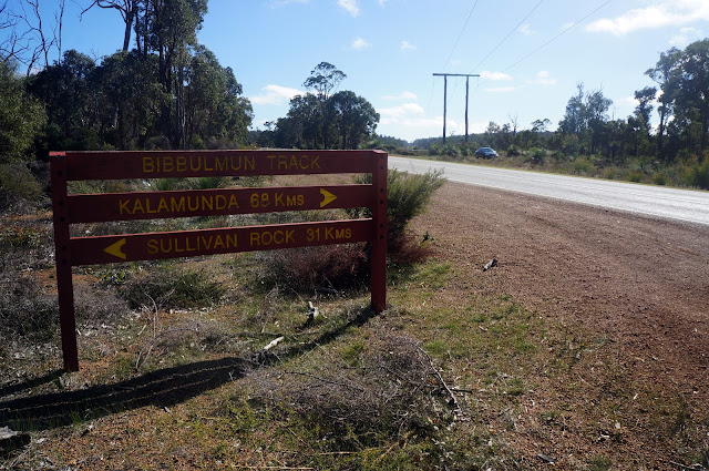
From there, the track reaches the Brookton Hwy crossing, where a large car park area makes this an excellent track access point.
This sectional day walk is pleasant enough, however for me it is one of the least essential sections of the track. Much of the forest here is fairly thin, and the low-lying swampy areas are not particularly exciting. It is possible that the wildflowers in the area are magnificent in Springtime, but there are better areas of the track for this. Likewise, Abyssinia Rock is less impressive than Sullivan Rock, and walks on either side of Sullivan lead to mountain views. With this area having been burnt by fire, I would suggest Marginata Rd to Brookton Hwy is only essential to those looking to complete a sectional End to End.

Having set out to do this walk a month earlier and taking the wrong turn, Alissa and I were pleased to be able to find the correct turn off for Four Ways Rd from Marginata Rd and got ourselves onto the Bibbulmun Track with very little difficulty. The walk in from Four Ways Rd and the first few kilometres of walking are pleasant if not overly exciting Jarrah forest, with a fallen, upside-down Jarrah being the most interesting features of this section.

The Jarrah forest clears to an area that is fairly low-lying and swampy, and looks to be the kind of place to be seasonally inundated in late Winter after significant rains.

Duck boards are used intermittently in this section to assist walkers in getting through potentially muddy areas. During our walk in late June, this area was not particularly wet yet, and we encountered no flooding or muddiness issues.

Walking to Canning Campsite was not a particularly long distance. The campsite is in a relatively open space, and yet this campsite just barely survived being burnt by bushfire in January 2016. Being relatively dull even then, I can imagine this area being even less inviting now. Indeed, the Bibbulmun Track Foundation have done as far as to suggest walking other sections of the track for the time being.

Beyond the hut, the track intersected with some old vehicle tracks, and we were disappointed to read in the hut's log book that people are illegally driving on these closed tracks. We witnessed a car driving through here ourselves. It is disheartening to see people willfully ignoring the rules and potentially spreading Dieback in at risk areas - particularly likely given the moistness of the swampy soils. There are a number of cleaning stations along the track - please ensure that you use them.

The highlight of the day is Abyssinia Rock. Walkers heading north towards Brookton Hwy will encounter the smaller, first half of the rock first, however beyond a thin line of shrubbery is the main expanse. Ephemeral Gnamma pools cover the mossy rock, and its overall appearance is similar to the larger and more impressive Sullivan Rock.


The walk up the rock is a relatively easy and worthwhile ascent - this is the best part of this section, and its best to savour it.

Beyond Sullivan Rock is another boot cleaning station, after which the track ascends to Brookton Hwy. The scrappiness of the forest allow for views of the hills and small mountains beyond, and I can imagine walkers heading South would be filled with anticipation for the Canning to Monadnocks section to come.

From there, the track reaches the Brookton Hwy crossing, where a large car park area makes this an excellent track access point.
This sectional day walk is pleasant enough, however for me it is one of the least essential sections of the track. Much of the forest here is fairly thin, and the low-lying swampy areas are not particularly exciting. It is possible that the wildflowers in the area are magnificent in Springtime, but there are better areas of the track for this. Likewise, Abyssinia Rock is less impressive than Sullivan Rock, and walks on either side of Sullivan lead to mountain views. With this area having been burnt by fire, I would suggest Marginata Rd to Brookton Hwy is only essential to those looking to complete a sectional End to End.


0 comments:
Post a Comment