

A relatively short sectional day walk on the Bibbulmun Track, the walk from Conspicuous Beach to Peaceful Bay is dominated by impressive coastal walking. Taking in views from high coastal cliffs, a large granite dome, biodiverse heathlands and rocky, isolated beaches, the wild Southern Ocean's crashing waves are a spectacular highlight, while the gentle waters of Peaceful Bay provide a tranquil finish.
Distance: 15.2 km (one way)
Gradient: Starts with an ascent up to Conspicuous Cliff and has a later ascent to Castle Rock at Point Irwin, but is otherwise a generally flat to gently downhill gradient.
Quality of Path: Very clear and well maintained up for the first half, and then very overgrown in spots.
Quality of Signage: Largely well signed in the first half, with the Waugal providing clear directional information. Some heavily weathered signs in sections are less clear, with the Waugal image faded away on some markers.
Experience Required: Bush Walking Experience Recommended
Time: 5 Hours
Steps: Some steps at beach access points (Conspicuous Beach and Peaceful Bay)
Best Time to Visit: Best to avoid in very hot or stormy conditions
Entry Fee: No
Entry Fee: No
Getting There: Conspicuous Beach and Peaceful Bay are easily accessible from South Coast Hwy. Conspicuous Beach is located at the end of Conspicuous Beach Rd while Peaceful Bay is on Peaceful Bay Rd. Ficifolia Rd runs parallel to South Coast Hwy and links the two roads.
Ticking off another section of the Bibbulmun Track always elicits a wonderful sense of achievement, but it is all the better when that section fills a gap between two completed sections adjacent to it. Having walked Boat Harbour to Peaceful Bay in May last year and completed the track from Conspicuous Beach to Walpole in December, tackling Conspicuous Beach to Peaceful Bay meant we would finally fill in the gap between these walks - bringing us closer to completing the Walpole to Denmark section of the Track.
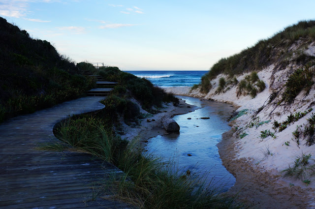
For this walk, we used the same Conspicuous Beach access point we had used previously, although instead of following the steps up to the lookout, we instead followed the steps and boardwalk down to the beach itself.

A small stream is visible along the boardwalk and then flows into the ocean at the beach. When I walked Denmark to Walpole in 2003, my hiking group and I discovered the water from this stream to be crystal clear and fresh tasting. Having lost a water bottle and having to drink from the tannic Frankland River just they day before, the taste of the stream's clean water was one of my strongest memories of that hike. Having set off with enough water, Alissa and I did not need to fill up this time, but we nevertheless appreciated the stream's idyllic contribution to the scenery - especially juxtaposed against the extremely wild waves and violent rips we witnessed on this day.

From the beach, the track heads inland into dune heathlands. The soft sands in this area made for slower going than we anticipated, and continued to be the main challenge of what was an otherwise easy day.

The track rises away from the dunes to the top of the coastal cliffs via a switchback, with the soft sands giving way to firmer soils and a thriving community of grass trees.

As the track skirts the edge of the limestone cliffs, the Track offers stunning views of the Conspicuous Beach for one last time before heading east towards Rame Head.

Although some vantage points along the way allow for views of Rame Head, a slightly disappointing aspect of this section is that the track strays inland away from the cliffs. Given this is the inland location of Rame Head campsite, the move away from the coast is undoubtedly a practical consideration given the wild winds, however a spur trail to more coastal views would have been a nice addition.

Rame Head Campsite is nevertheless well sited (save for its notoriety as a mosquito haven in the evenings), and we found the hut to be well maintained. Whoever takes care of the hut has made some nice customisations such as clotheslines and the provision of citronella candles, and trimmed a bush into a neat topiary.

From the hut, the Track follows an old vehicle track that is probably used by maintenance to access Rame Head, before entering an area of narrow purpose built walk tracks and occasional boardwalks.

While pleasant enough, the lack of coastal scenery along almost 5 kilometres of the walk makes it a little dull, especially when you know the beaches are just beyond the dunes to the south of the track. Looking at the 1st Edition of the Southern Half guide, the Bibbulmun used to return to the coast sooner, however the danger of king waves seemed to have risk assessed the track into tamer conditions.

Still, at the right time of year I can imagine this inland section being profuse with wildflowers - even in mid-Autumn, there were a number of plants flowering along this section of the track.

The track eventually returns to the coast, descending down a dune to a beach called The Gap (not to be confused with the much more famous Gap in Torndirrup National Park)

Strong, dumping waves crashed violently into the rocks creating an awe-inspiring sight. When we arrived at the beach, a large wave crashed into the rocks on the left side of the above picture, sending water high up into the air. Definitely not safe conditions for swimming.

From the beach, the track follows a low lying rocky headland a safe distance away from the water's edge. Again, the waves crashed wildly along this section of coastline, putting on a remarkable display of the forces of nature at work.

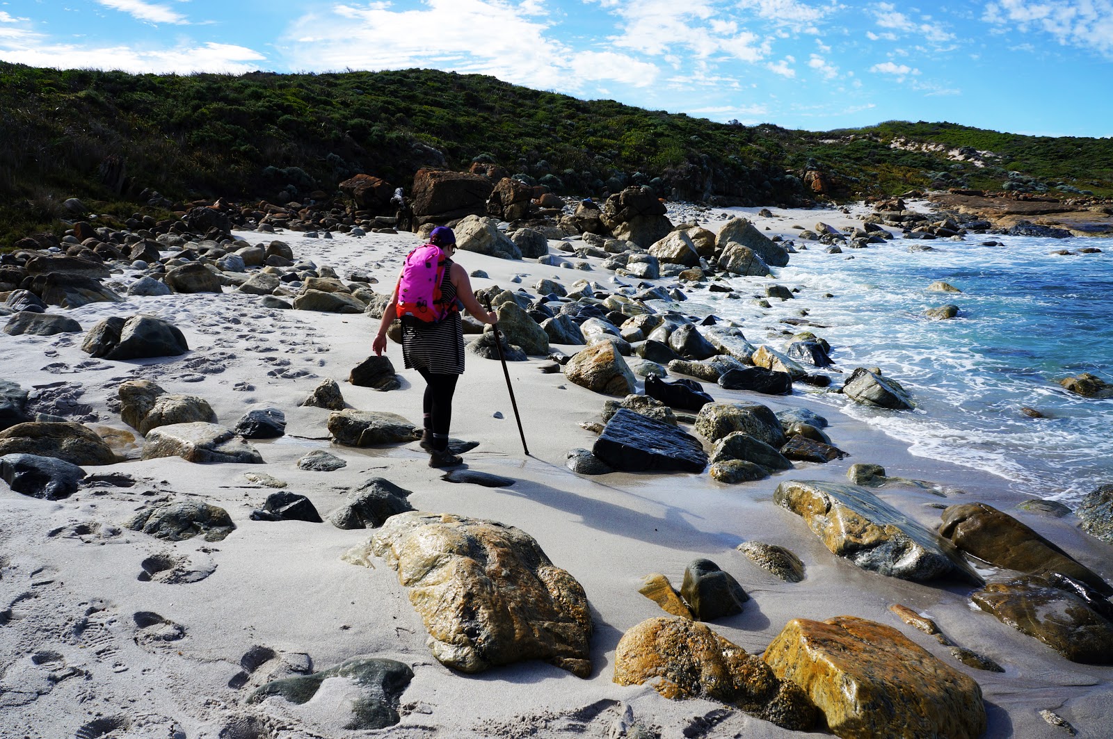
Beyond the rocky headland, the track return to beach. This beach is covered in large, rounded rocks that have been worn down by the turbulent ocean.

Along the beach, a large rock formation gives some indication of the tumultuous conditions in which the coastline was created. Bands in the rock running vertically suggest this rock had either shifted 180° at some stage or is a dike formed from magma flows. Given this coastline was once connected the Antarctica as part of the supercontinent Gondwana, this is hardly surprising.

Heading south-east, the Bibbulmun reaches Point Irwin - the most southerly section of the day's walk before heading north towards Peaceful Bay.

Considering a beach along this stretch of coast is called the Gap, it should be of little surprise that the large granite dome that forms the highest peak of Point Irwin is creatively named Castle Rock (not to be confused with the Castle Rock on the Granite Skywalk in the Porongurups, or the other Castle Rock along the Meelup Trail near Dunsborough). After much soft beach sand walking, the hard granite surface was a treat, even if it was an uphill climb.


The views from the top are typical of WA's South Coast - rugged and characteristically spectacular.

The track from Point Irwin to Peaceful Bay featured some of the worst maintained and seriously overgrown stretches of the Bibbulmun that Alissa and I have walked. The photo above is literally right through the middle of the track, and obstacles such as these greeted us repeatedly at regular intervals. Having heard from a passing walker that she had seen three brown snakes just the day before, walking through such overgrown areas was a bit unnerving and we made sure to stomp our feet as we made our way through.

After the turbulent beaches from Conspicuous Beach to Point Irwin, the waters become increasingly calm as the track heads north to Peaceful Bay. The track descends to the quiet beach pictured above before walking around the coast along the rocks.

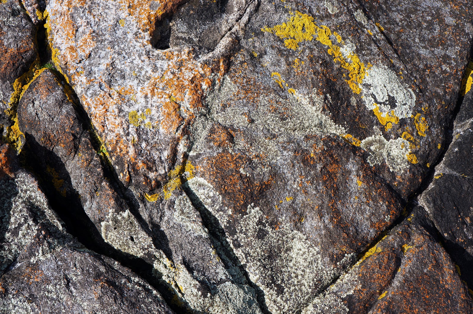
The calmer conditions seemed ideal for lichen growth, with their bright colours creating abstract 'paintings' on the rocks.

A slightly funky smell greeted us we walked along the rocks, and several large bones were the source. At the time we thought these seriously huge bones might have been from a whale's flipper, however with a whale's handlike internal structure, the long bone seemed to be something else. Was it a whale's jaw, or a fin from another animal like a shark? Whatever the case, it was an incredible sight to see - only adding to what was an already memorable coastal walk.

Around the rocks, the track follows the beach into Peaceful Bay. Given the expanse of beach we had to walk, Alissa and I took off our shoes. This made the walk considerably more comfortable and allowed us to dip or feet in the cool waters from time to time.

Upon reaching the small holiday settlement of Peaceful Bay (fairly busy on this long weekend), the track ascends a flight of wooden stairs and follows a short path that led to where our car was parked. With that, we'd connected up all the sections from Walpole to Boat Harbour as we head closer towards completing our section End to End.
Apart from the relatively uninteresting inland section, Conspicuous Beach to Peaceful Bay was an excellent walk filled with incredible coastal scenery. Compared with Boat Harbour to Peaceful Bay, the closer proximity to wild, rocky beaches along this section of the track meant it probably had the edge on the former section in this regard, although it lacked the diversity of the Showgrounds grassy plains and the canoe river crossing. Although the soft sands do slow you down, the overall easiness of the terrain makes this an easy section to recommend.

Ticking off another section of the Bibbulmun Track always elicits a wonderful sense of achievement, but it is all the better when that section fills a gap between two completed sections adjacent to it. Having walked Boat Harbour to Peaceful Bay in May last year and completed the track from Conspicuous Beach to Walpole in December, tackling Conspicuous Beach to Peaceful Bay meant we would finally fill in the gap between these walks - bringing us closer to completing the Walpole to Denmark section of the Track.
For this walk, we used the same Conspicuous Beach access point we had used previously, although instead of following the steps up to the lookout, we instead followed the steps and boardwalk down to the beach itself.

A small stream is visible along the boardwalk and then flows into the ocean at the beach. When I walked Denmark to Walpole in 2003, my hiking group and I discovered the water from this stream to be crystal clear and fresh tasting. Having lost a water bottle and having to drink from the tannic Frankland River just they day before, the taste of the stream's clean water was one of my strongest memories of that hike. Having set off with enough water, Alissa and I did not need to fill up this time, but we nevertheless appreciated the stream's idyllic contribution to the scenery - especially juxtaposed against the extremely wild waves and violent rips we witnessed on this day.

From the beach, the track heads inland into dune heathlands. The soft sands in this area made for slower going than we anticipated, and continued to be the main challenge of what was an otherwise easy day.

The track rises away from the dunes to the top of the coastal cliffs via a switchback, with the soft sands giving way to firmer soils and a thriving community of grass trees.

As the track skirts the edge of the limestone cliffs, the Track offers stunning views of the Conspicuous Beach for one last time before heading east towards Rame Head.

Although some vantage points along the way allow for views of Rame Head, a slightly disappointing aspect of this section is that the track strays inland away from the cliffs. Given this is the inland location of Rame Head campsite, the move away from the coast is undoubtedly a practical consideration given the wild winds, however a spur trail to more coastal views would have been a nice addition.

Rame Head Campsite is nevertheless well sited (save for its notoriety as a mosquito haven in the evenings), and we found the hut to be well maintained. Whoever takes care of the hut has made some nice customisations such as clotheslines and the provision of citronella candles, and trimmed a bush into a neat topiary.

From the hut, the Track follows an old vehicle track that is probably used by maintenance to access Rame Head, before entering an area of narrow purpose built walk tracks and occasional boardwalks.

While pleasant enough, the lack of coastal scenery along almost 5 kilometres of the walk makes it a little dull, especially when you know the beaches are just beyond the dunes to the south of the track. Looking at the 1st Edition of the Southern Half guide, the Bibbulmun used to return to the coast sooner, however the danger of king waves seemed to have risk assessed the track into tamer conditions.

Still, at the right time of year I can imagine this inland section being profuse with wildflowers - even in mid-Autumn, there were a number of plants flowering along this section of the track.

The track eventually returns to the coast, descending down a dune to a beach called The Gap (not to be confused with the much more famous Gap in Torndirrup National Park)

Strong, dumping waves crashed violently into the rocks creating an awe-inspiring sight. When we arrived at the beach, a large wave crashed into the rocks on the left side of the above picture, sending water high up into the air. Definitely not safe conditions for swimming.

From the beach, the track follows a low lying rocky headland a safe distance away from the water's edge. Again, the waves crashed wildly along this section of coastline, putting on a remarkable display of the forces of nature at work.
Beyond the rocky headland, the track return to beach. This beach is covered in large, rounded rocks that have been worn down by the turbulent ocean.

Along the beach, a large rock formation gives some indication of the tumultuous conditions in which the coastline was created. Bands in the rock running vertically suggest this rock had either shifted 180° at some stage or is a dike formed from magma flows. Given this coastline was once connected the Antarctica as part of the supercontinent Gondwana, this is hardly surprising.

Heading south-east, the Bibbulmun reaches Point Irwin - the most southerly section of the day's walk before heading north towards Peaceful Bay.

Considering a beach along this stretch of coast is called the Gap, it should be of little surprise that the large granite dome that forms the highest peak of Point Irwin is creatively named Castle Rock (not to be confused with the Castle Rock on the Granite Skywalk in the Porongurups, or the other Castle Rock along the Meelup Trail near Dunsborough). After much soft beach sand walking, the hard granite surface was a treat, even if it was an uphill climb.


The views from the top are typical of WA's South Coast - rugged and characteristically spectacular.

The track from Point Irwin to Peaceful Bay featured some of the worst maintained and seriously overgrown stretches of the Bibbulmun that Alissa and I have walked. The photo above is literally right through the middle of the track, and obstacles such as these greeted us repeatedly at regular intervals. Having heard from a passing walker that she had seen three brown snakes just the day before, walking through such overgrown areas was a bit unnerving and we made sure to stomp our feet as we made our way through.

After the turbulent beaches from Conspicuous Beach to Point Irwin, the waters become increasingly calm as the track heads north to Peaceful Bay. The track descends to the quiet beach pictured above before walking around the coast along the rocks.
The calmer conditions seemed ideal for lichen growth, with their bright colours creating abstract 'paintings' on the rocks.
A slightly funky smell greeted us we walked along the rocks, and several large bones were the source. At the time we thought these seriously huge bones might have been from a whale's flipper, however with a whale's handlike internal structure, the long bone seemed to be something else. Was it a whale's jaw, or a fin from another animal like a shark? Whatever the case, it was an incredible sight to see - only adding to what was an already memorable coastal walk.

Around the rocks, the track follows the beach into Peaceful Bay. Given the expanse of beach we had to walk, Alissa and I took off our shoes. This made the walk considerably more comfortable and allowed us to dip or feet in the cool waters from time to time.

Upon reaching the small holiday settlement of Peaceful Bay (fairly busy on this long weekend), the track ascends a flight of wooden stairs and follows a short path that led to where our car was parked. With that, we'd connected up all the sections from Walpole to Boat Harbour as we head closer towards completing our section End to End.
Apart from the relatively uninteresting inland section, Conspicuous Beach to Peaceful Bay was an excellent walk filled with incredible coastal scenery. Compared with Boat Harbour to Peaceful Bay, the closer proximity to wild, rocky beaches along this section of the track meant it probably had the edge on the former section in this regard, although it lacked the diversity of the Showgrounds grassy plains and the canoe river crossing. Although the soft sands do slow you down, the overall easiness of the terrain makes this an easy section to recommend.


0 comments:
Post a Comment