

The first day of an eight day hike on the Overland Track, this first section of the track leads walkers from the Ronny Creek trailhead to Waterfall Valley. Often considered the hardest day of the track, this spectacular day of walking is dominated by beautiful glacier-carved landscapes, with Crater Lake and Cradle Mountain being the highlights - the latter of which can be summited via an optional side trail.
Distance: 12.7 km (one way - 10.7 km for the main track + 2 km Cradle Mountain side trip)
Gradient: A steep climb to Marion's Lookout, and a very steep scramble to the top of Cradle Mountain. Relatively gentle otherwise, with a moderately steep descent to Waterfall Valley
Quality of Path: Very clear and well maintained. Much of this section is under boardwalk, however some stretches along rocky paths are highly uneven. Scrambling is required on the Cradle Mountain side trip.
Quality of Signage: Largely well signed, with clear signage at junctions with other trails
Experience Required: Previous Bushwalking Experience Recommended
Time: 6.5 Hours, including lunch
Steps: Many steps, both formal and informal
Best Time to Visit: Spring-Autumn
Entry Fee: Yes. National Park Fees apply and an Overland Pass is required to walk the entire track during the hiking season
Getting There: Access is via Cradle Mountain Rd (Route C132). Regular shuttle buses run from the Cradle Mountain Visitor Centre to the Ronny Creek trailhead. Entry Fee: Yes. National Park Fees apply and an Overland Pass is required to walk the entire track during the hiking season

After an eventful morning of waking up two hours too early for the 8am bus (my mistake), having an incredibly rude and angry bus driver for the long and nauseatingly windy drive to Cradle Mountain and a very informative and dryly humourous driver for the shuttle bus to the Overland Track terminus, Alissa and I were finally signing in at the Ronny Creek trailhead by midday. Usually preferring to start our hikes fairly early in the morning, this was an uncharacteristically late start for Alissa and I, but with long Summer days and daylight savings in Tasmania meaning sunset after 8pm, there was still considerable time for us to get to our overnight hut destination at Waterfall Valley and to undertake the side trip to the summit of Cradle Mountain itself.

The weather for our first day was bitterly cold, made all the more chilling thanks to intensely strong winds blowing across the landscape. Having travelled to Tasmania from Western Australia to extend our hiking season beyond the inhospitable Perth Summer, Alissa and I were well prepared for freezing cold alpine weather in December, and it was the first time that I have ever kept my hiking vest on for the entire time I was walking!

Wombats are not native to Western Australia, so Alissa and I were particularly excited by the prospect of seeing a Wombat in the wild while in Tasmania. Within ten minutes of starting our walk, the Overland Track delivered with a Wombat casually foraging in the bushes just to the left of the track. We took this as an auspicious start to our walk, and we were immediately under the Overland's spell.

During the hiking season, hikers must pay to walk the Overland Track in full, however day hikes along the Overland to Cradle Mountain are permitted, and there are a network of other trails between the Cradle Mountain Visitor Centre and the mountain itself that intersect with the main track. As such, this first section to Waterfall Valley is much busier that later sections of the track, and walkers will have to pay attention to the signage to ensure that they are heading the right way.

After the initial easy first kilometre walking along flat and easy boardwalk over grass plains, the trail begins the long ascent to Marion's Lookout. Occurring so early in the walk, the almost relentless 300 metre rise over two kilometres means that the track throws hikers in the deep end almost immediately, however there is much to see along the way to make it worthwhile. Upon leaving the grass plains, the landscape transitions to a more typically Australian scene of Eucalypts with a wildflower-rich understorey.

As the track ascends, a more surprising and remarkable change occurs as it unexpectedly enters the first short stretch of rainforest along the track. Alissa and I were immediately wowed by the beauty of the rainforest, especially since it even featured a waterfall. At this point we passed an older walker named Mary, who we would later discover is a veteran hiker who had done the Overland Track back in the 1980s and had an impressive 30 years of hiking experience under her belt.

The rainforest section is fairly brief however, and we were soon rising up a set of stone steps through more open terrain.

At the two kilometre mark, the Overland passes Crater Lake. A lake surrounded by a tall, steep amphitheatre-like ridge, Crater Lake is not actually an impact crater but a cirque carved be glaciers over previous ice ages. Along with Dolerite peaks, glacial lakes are a major feature of the Overland Track, culminating in the massive Lake St Clair that serves as the walk's finale.

As we walked alongside Crater Lake, we passed a family of five with full packs that indicated they were doing the Overland and not just a day hike. Although we said hello in passing, we would get to know the family fairly well over the week as they had a similar itinerary to ourselves, being the only other people who started on the same day as us who also did the Pine Valley overnight side trip.

The trail rises up from Crater Lake, offering views of other glacial lakes nearby. The smaller lake is Lake Lilla, while the larger Lake is Dove Lake. Dove Lake is used by some hikers as an alternative start point for the Overland Track as it offers walkers a chance to see the famous view of Cradle Mountain towering over Dove Lake and its boat shed.

Although we had been ascending since the one kilometre mark, the track was about to become really steep as it climbed to the top of Marion's Lookout.

When people talk about the first day of the Overland Track as being the hardest, it is because the last kilometre of the ascent to Marion's Lookout climbs 200 metres up a long flight of steps.

At points the climb is so steep that there is a chain running along the ascent to assist walkers in making their way up to ascent.

As tough as the climb can be, the views of Crater Lake along the way are spectacular with Crater Falls visibly cascading into the lake below.

Finally at the top of Marion's Lookout, Alissa and I were privy to the lookout's spectacular view of Cradle Mountain. Although some wisps of cloud were still rolling around the top of the mountain, we were fortunate to see the vast majority of Cradle Mountain as we could see that it had been enshrouded by cloud on the way up, and the area is notorious for its lack of clear days.
From Marion's Lookout, the excellent views of Cradle Mountain continued. In the foreground, Alissa and I were delighted to see a small patch of snow just off the track. A friend living in Launceston has referred to that patch of snow as being immortal - if there is ever going to be snow near Cradle Mountain, it will be that patch! In the distance we could make out the form of Barn Bluff largely engulfed in clouds.


Five kilometres into the walk, Alissa and I reached the first hut along the Overland Track - Kitchen Hut, just before the turn off to the Cradle Mountain summit side trip.

Kitchen Hut is one of the older, historical huts along the track. Like most of the older huts, Kitchen Hut is not be used as an overnight shelter except in emergency situations. As such, it is mainly used as for a lunch break and an ideal location to store your main pack when tackling the side trip to the summit of Cradle Mountain. After chatting with a few other hikers and a ranger named Michael, Alissa and I had our belated lunch before putting our packs in Kitchen Hut and heading off with our day packs to Cradle Mountain.

The turn off for Cradle Mountain is only about 100 metres further along the track from Kitchen Hut. Although the sign refers to the track to the left as the Face Track, the next sign beyond clearly indicates the way to the summit.

The trail to the summit is marked with metal pegs that provide relatively clear navigational information, although some of these pegs have become bent or fallen over. The initial section is steep but relatively straightforward walking up informal, rocky steps.

Once reaching the Dolerite boulders and columns, the walked becomes a wilder route that requires a lot of scrambling through seemingly endless boulder fields. The climb was in some ways quite similar to the boulder fields of Toolbrunup in Western Australia's Stirling Range, and I was glad that we had the experience of Toolbrunup under our belt before tackling the longer scramble of Cradle Mountain.

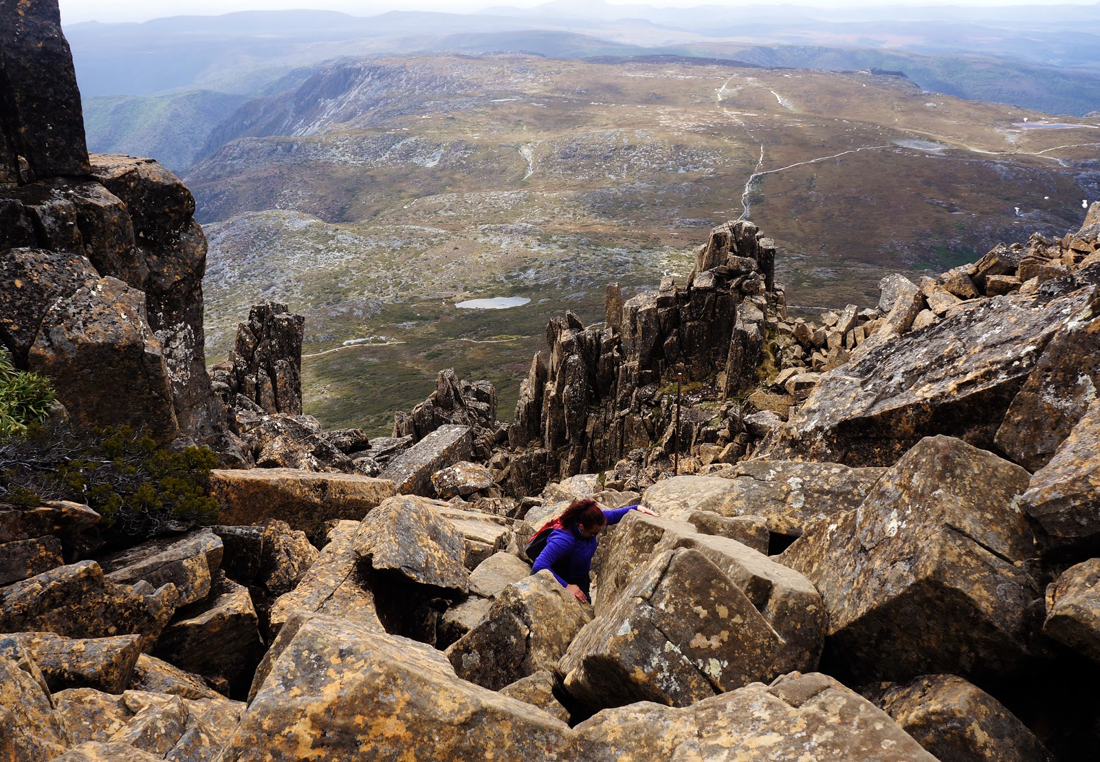
I love a mountain walk with a decent amount of rock scrambling, and in many ways I find it easier than a relentless set of stairs going up and up. Being fairly confident with picking my way up boulders, I was making my way up the mountain fairly quickly however I had noticed that I was some distance ahead of Alissa. After waiting for Alissa to catch up, Alissa let me know that the strong winds were making the climb a bit unnerving for her. Although it hadn't played on my own climbing confidence, the strong winds were definitely an extra element of challenge - and one that would become increasingly problematic the closer we got to the summit.

All the way up the climb, the summit appears to be within sight going to the top right of the mountain.

Unfortunately, this is only a false summit; once we reached the top of this first climb the track descends slightly to a saddle before rising up again to reach the true summit. A Canadian day hiker we had been walking with had had enough by this point as it was getting late for him to make it back for the last bus to the visitor's centre, and Alissa was satisfied that this was high enough for her. Although it was now roughly 3:30pm, I was still keen to make it to the summit so I pressed on.

From the saddle, walkers are privy to excellent views to the east. That is, if you're lucky with the weather. The views eastwards were marred slightly by cloud, however the columnar shapes of the Cradle Mountain's Dolerite made for a very dramatic landscape to be walking in.

The scramble up the true summit featured some awkward moves that would be even more awkward on the way down, but I was excited to see the end in sight. Unfortunately just as I made it up to the top to undertake the final walk across to the summit cairn, extremely strong winds blew in, bringing clouds over the peak.

The winds hadn't phased me up to this point, but with no cover, very poor visibility and no longer being in Alissa's line of sight for safety, there seemed to be little point in continuing on.

Given the poor visibility, the walk back down was somewhat challenging as we had to pay special attention to identifying where the markers were. Some of the scrambling that was fairly easy going up was a bit more difficult going down, and it became pretty clear that any hikers behind us had long given up on the ascent and we were the only two people still on the mountain.

On our way down to Kitchen Hut, we ran into a duo of Malaysian/Singaporean hikers who had given up climbing Cradle Mountain and had just picked up their bags and were on their way to Waterfall Valley. Given how quiet the area around Cradle Mountain had become, I was glad to run into other hikers still out and about. Upon entering Kitchen Hut, we were surprised to see an old German Overland Track hiker had set up his stove and was having a meal. While collecting our packs, we had a brief chat with the old man and were surprised to find out that he had walked a section of the Bibbulmun Track before heading to Tasmania, as well as having visited Uluru and other places in the Northern Territory. More surprising however was the fact that he had decided to stay the night at Kitchen Hut - something that you're not really meant to do unless it is an emergency, and its only four kilometres from Kitchen Hut to the much better facilities at Waterfall Valley. We thought that he must just be struggling with the terrain, so we wished him safe travels for the next day and head on our way.

The winds remained pretty intense and the scenery was shrouded in cloud, concealing what I'm sure would have been stunning views.

Although the elevation charts we had seen seemed to be pretty flat from Cradle Mountain until just before Waterfall Valley, the track did feature some more minor ascents, made more difficult by the lack of boardwalk for a long stretch. Without the boardwalk, Alissa and I were walking on rocky, natural surfaces. Unlike the fine gravel of the Bibbulmun Track, these stones were uneven and on all sorts of angles, making for terrain that could easily lead to twisted ankles if one was not thinking carefully about where they were placing their feet. This was slower going than I had hoped, especially since we were now experiencing sideways rain blowing in from the right side of the track!

We soon overtook the Malaysian/Singaporean duo, as well as a father and son also heading to Waterfall Valley. Although it really made no difference, I felt comforted knowing we would not be the last ones in for the night. With the poor visibility and sideways rain however, it felt like we had been walking for a lot longer than 4 kilometres normally would take. It was particularly demoralising to reach a sign near the Barns Bluff side trip that said we had one hour more of walking right when we thought there couldn't be much more to go for the day!

The last hour thankfully was more like 30-40 minutes, and as we were glad to be descending a flight of steps as it meant that Waterfall Valley was not far now.

Waterfall Valley is unusual as it is home to two huts - one of the older, smaller huts that only sleep eight and a larger, modern hut that sleeps about 24. Had we arrived earlier, I would probably have aimed to stay in the smaller hut or set up our tent to have a bit more privacy, however as the third last duo to arrive and with the rain getting worse, Alissa and I were happy to accept room in the bigger hut when we were greeted by the very friendly hut warden. After taking off our gear in the mud room (an enclosed verandah that keeps the main hut clean), Alissa and I were within the busy hive of activity that was the main Waterfall Valley Hut.

The poor weather had obviously convinced a lot of people that staying in the hut was the better alternative, and it was not surprising to find most of the sleeping shelves occupied. We were thankfully able to find a spot on the other side. After setting up our stove and eating dinner, Alissa and I were pretty keen to get to sleep after a long day and to get into our routine of going to sleep by sunset and waking up by sunrise - we would not be having another late start for the rest of our time on the track!
In spite of the cloudy and windy weather, the first day on the Overland was excellent, and would easily rank as one of the track's best - as well as one of the most stunning and magical days of walking we've done to date. The surprise of the rainforest section and waterfall on the way to Marion's Lookout and the incredible views of Cradle Mountain from the Lookout itself and along the summit track remained some of the most vivid and memorable of the entire walk. Even if not doing the full Overland Track, this first day is definitely worth doing as either a day trip to Cradle and back, or an overnight at Scott-Kilvert Hut (an alternative hut not used by the Overland) as its captures the essence of why the Overland Track is such a special walk. For us, this was a great start to our Overland Track adventure, and there were still 7 more days to go.


0 comments:
Post a Comment