
A spectacular 20 km loop walk in the Snowy Mountains, the Main Range Track traverses the Australian high country on its way to Mt Kosciuszko - the highest mountain on the Australian mainland. Crossing the famous Snowy River and passing several beautiful glacial lakes, the sweeping 360° views and well formed track makes this a superb full day hike for the Summer season.
Distance: 20 km (loop)
Gradient: Several moderately steep ascents and descents to Mt Koskiuszko, with a gentle descent back to the trailhead on the return loop section
Quality of Path: Very clear and straightforward - path surface is a combination of paving, gravel and compacted dirt. Some sections may be under snow.
Quality of Signage: Clear trailhead and information at trail junctions; very little signage otherwise. Track is however very easy to follow during the Summer season.
Experience Required: Previous Bushwalking Experience Recommended.
Time: 6-9 Hours
Steps: Several formal and informal steps
Best Time to Visit: Late Spring to Early Autumn - Summer would be best. Winter can be potentially dangerous - people have died in the area due to exposure
Entry Fee: Yes. Special Kosciuszko National Park Fees apply.
Entry Fee: Yes. Special Kosciuszko National Park Fees apply.
Getting There: Access to the the trail is at the cul-de-sac at the end of Kosciuszko Rd, 8.6 kilometres from Perisher Valley. Parking is available along the road.

After finishing 2016 with our Christmas hike on the Overland Track and a few days in Hobart, Alissa and I started 2017 by heading off for the next part of our adventure by catching an early morning flight to Canberra. Although we were in Canberra to check out the museums and art galleries of our nation's capital, it was the city's close proximity to the Snowy Mountains that was the main attraction. Alissa and I had thoroughly enjoyed the Grand Canyon Walk in the Blue Mountains when we visited Sydney in 2015, and researching other walks in New South Wales led me to the Main Range Track - a 20 kilometre loop that includes the summit of Mt Kosciuszko. Getting to do an alpine walk amongst the highest mountains on the Australian mainland seemed like a real treat, and it was an early must-do of our holiday itinerary. Basing ourselves in Jindabyne and having to postpone our walk by a day due to thunderstorms, Alissa and I headed out into Kosciuszko National Park for our first walk of 2017.

From the well signed trailhead at the cul-de-sac on Kosciuszko Rd, the Main Range Track follows a paved path immediately down to a river crossing. This is the famous Snowy River from Banjo Patterson poetry, and it is an early highlight of the walk given that walkers must hop across a series of stepping stones to reach the other side.

From the Snowy River, the track immediately ascends back up the other side, following a clear and well maintained gravel path past a series of granite domes rising out of the alpine meadows. The track rises almost continually over this stretch of the track, however the gradient is fairly moderate.

Along the ascent, the track dips down slightly to cross another stream over a series of stepping stones. From here, it is only a short walk until reaching the junction with the Main Range Track and the side trip to Blue Lake, 3.2 kilometres into the walk.

The side track to Blue Lake actually goes all the way to the shores of Blue Lake, however at the time we walked it the NSW National Parks and Wildlife Service were doing track maintenance and had closed it off. As such, I had to settle for the short walk from the track junction to the Blue Lake Lookout.

Even with the sun at an inopportune angle, Blue Lake was a truly beautiful sight The largest and most stunning of the four glacial lakes in the Main Range, Blue Lake is recognised as a wetland of international importance, and is also apparently a popular spot with local rock climbers.

Back onto the actual Main Range Track, Alissa and I continued ascending as the track continued on to Carruther's Peak. The snow fields in Kosciuszko National Park had reached their maximum depth quite late in the 2016 season, and as such Alissa and I were lucky to pass by quite a few patches of remnant snow as we walked along the track.

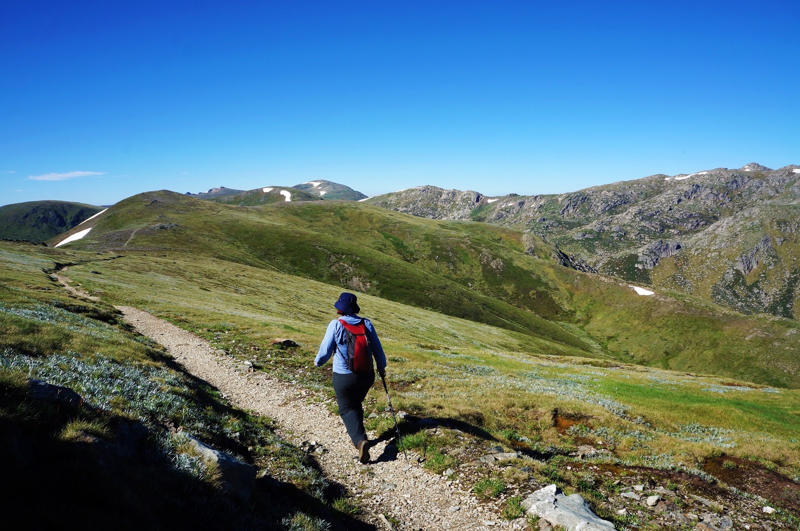
Leading to Carruther's Peak, the track skirts the edge of a ridge with spectacular views to the north. The mountains beyond the track look rugged and wild, and appeared to be significantly more difficult walking than the higher peaks we were walking over and amongst.

Heading up Carruther's Peak, the track was actually paved in rough-hewn granite slabs and edged with what looked like bales of hay.

After roughly 2 kilometres of continuous uphill walking from the Blue Lake turnoff, the Main Range Track reaches the summit of Carruther's Peak. The Peak provides excellent 360° views of the surrounding landscape of peaks, valleys and wildflower-filled alpine meadows.
Descending from Carruther's Peak, Alissa and I ran into a middle aged couple fully laden with heavy packs. I guessed correctly that they were doing the Australian Alp Walking Track (AAWT) - the long distance walking track that stretches from Walhalla, Victoria to Tharwa, ACT. Though not as long as the Bibbulmun Track or Heysen Trail, the AAWT is considerably harder due to the need for food drops and navigation through wilderness areas. By this stage, the couple were between 2/3 to 3/4 of the way through the walk. It's quite an adventure, and something I would consider doing in the far future.

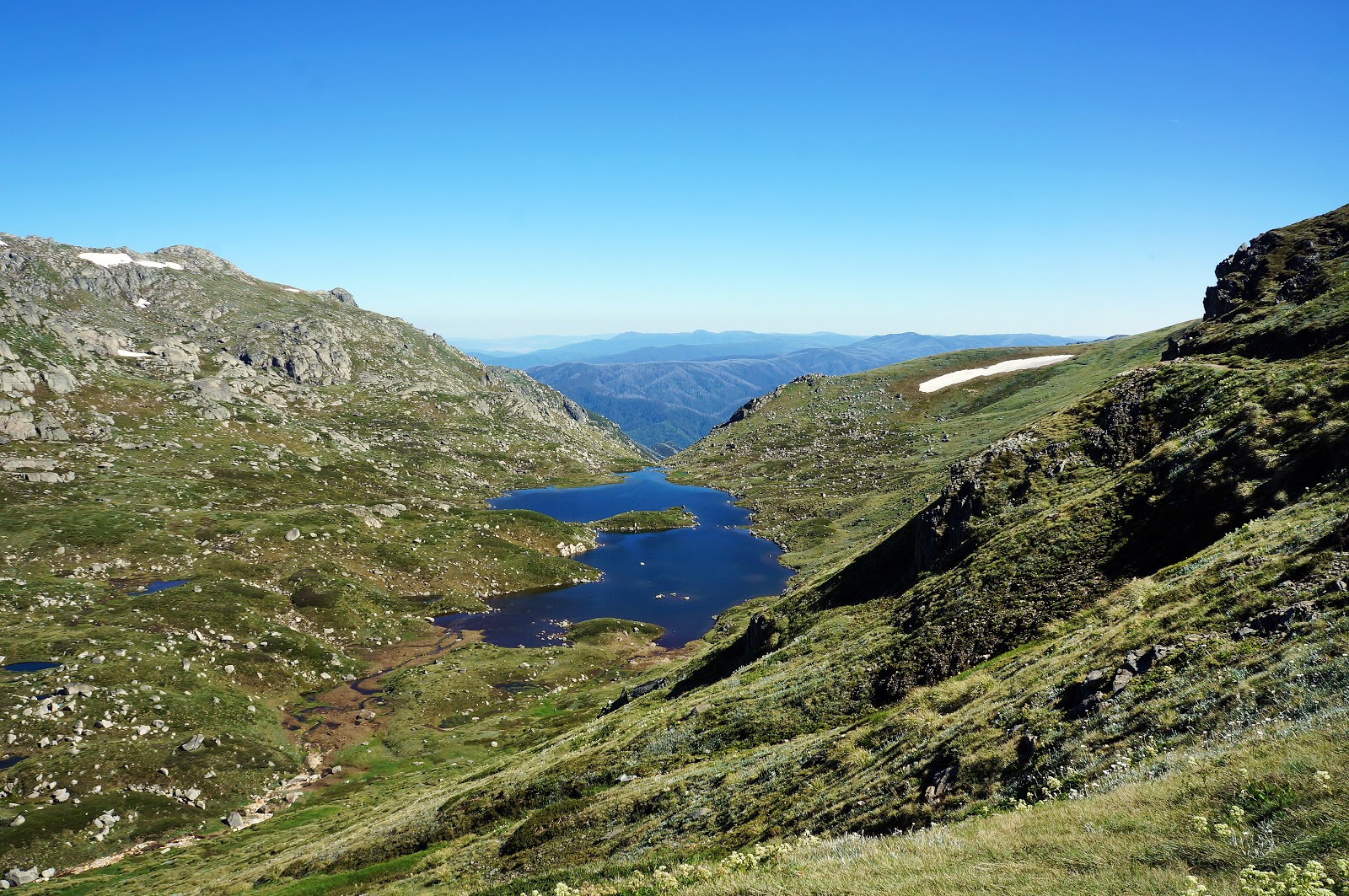
Continuing on along, the trail Alissa and I passed Club Lake - one of the smaller glacial lakes in the Main Range area.

Most of the Main Range Track is broad enough and solid enough for a small car to drive along, and from Carruther's Peak we could see a ranger driving to the Blue Lake junction to do some maintenance work. After descending Carruther's Peak and passing Club Lake, the trail narrows to a thin walk trail as it skirts past some rocky outcrops.

This was one of my favourite parts of the walk, as it was engaging while the views to the west were truly outstanding. In the valley below, Lake Albina was another of the region's beautiful glacial lakes. Across the valley was Mt Townsend, the second tallest mainland peak. Only 19 metres shorter than Mt Kosciuszko, Mt Townsend was actually the original Mt Kosciuszko, however the names were swapped when it was discovered that the current Kosciuszko was the true highest peak. Due to the easiness of climbing Kosciuszko, there is apparently a tradition of climbers reaching the peak of Mt Townsend bringing a rock from the bottom in their pack and leave it there, in time making the mighty Mt Townsend the taller mountain!

At the end of the rocky ridge overlook Mt Townsend and Lake Albina, the track continues along a rock paved path that meanders through boulders.

Having seen many patches of remnant snow along the walk, I was really hoping that a section of the track would actually head through snow at some point. As such, I was delighted to pass through a brief section along the rocky ridge as the track began its steepest ascent.

This steep climb, leading towards the side trail junction to Mt Kosciuszko climbed continually up steps. At one point it looked like the steps would end, however upon reaching the top of the steps even more steps became visible! Still, having just come from some seriously steep ascents on the Overland Track (such as Marion's Lookout and the Labyrinth side trip), these steps were not all that bad.

As the track levelled out, Alissa and I could make out the bunker-like facility built into the mountainside as pictured above (see top left). Knowing that this was the famous 'highest toilet in Australia', I knew that we were now not far from Kosciuszko.

A short distance away from the Kosciuszko junction, Alissa and I passed through a more substantial patch of snow.

Although the weather was not as hot as it had been when we climbed Mt Ossa, the lack of cloud cover and high UV rating meant it was beginning to get a bit warm. As such, Alissa and I made the most of the snow with a snow fight and filling our hats with cooling handfuls.

A few minutes after the second patch of snow, Alissa and I reached the junction with the side trip to the summit of Kosciuszko. At the point, the track became a lot more crowded as there is a much shorter and easier track from the Thredbo chairlift that also runs to Kosciuszko.

When people hear 'tallest mountain in Australia', images of Everest or Denali must come to mind, as a lot of our friends back in Perth congratulated us for reaching the summit. I knew that Kosciuszko was not exactly a tough scramble, however I was shocked to see just how easy the walk was to the summit - the paved track curves around the mountain at such a gentle gradient that we literally saw a woman pushing a pram to the summit, and I think a cautious person in a wheelchair could almost get themselves up to the top! In truth, the height of a mountain has less bearing on its difficulty that the ruggedness of the terrain - consider for example that Stapylton Amphitheatre in the Grampians is several leagues more challenging than climbing Kosciuszko and yet Mt Stapylton is only 495 metres tall compared to Kosciuszko's 2228 metres!


Still, it is not every day that you reach the top of the tallest mountain on the Australian mainland, and Alissa took the obligatory photo of me standing on top of Kosciuszko's summit cairn.

Back down from the summit and continuing on along the track, I decided to check out the bunker-like structure we had seen earlier. This is the highest toilet in Australia, built in 2007 to accommodate the 100,000 visitors to the summit over the Summer.

Beyond the toilets, the walk continues back down to the trailhead at Charlotte Pass by following a broad vehicle track.This vehicle track is actually the continuation of Kosciuszko Rd that is not longer open to car traffic. Up until the late 1970s, people used to be able to actually drive their cars all the way to the summit, however concerns about environmental degradation saw the road closed and pedestrianised. The road is now open only to walkers and cyclists.

A short distance from the toilets is Seaman's Hut, an emergency shelter built for the tough Winter conditions of the Main Range area. The hut was erected in 1929 after the death of Laurie Seaman, and was funded by Laurie's parents so as to provide shelter for those who found themselves in a similar predicament to their son.

Sadly, a plaque inside the hut shows that a snowboarding group died in the 1990s after the entrance to a snow cave they had sheltered in collapsed on them. They were found only 2.2 kilometres away from Seaman's Hut.

After a quick lunch at Seaman's Hut, Alissa and I continued on down the track. 1.5 kilometres after Seaman's Hut, Alissa and I crossed the Snowy River for a second time, utilising the old vehicle bridge of Kosciuszko Rd.

After crossing the Snowy River for the second time, the track continues to follow Kosciuszko Rd. Unlike the earlier part of the walk, this return section is less eventful as it does not cross streams on stepping stones or summit one of the other peaks of the Main Range. This is the nature of a track that was once a road, however it does provide spectacular views across the Snowy River Valley to the areas that we had walked through earlier in the day.

As the track descends to below the tree line, a profusion of Snow Gums can be seen along the track.

With their twisted forms and multi-coloured bark, Snow Gums are one of the most beautiful and striking species of Eucalypt, and they give the final kilometre of the walk a lot of character.

After walking amongst the Snow Gums, the gravel track reaches the cul-de-sac on Kosciuszko Rd, thus completing the loop through the Main Range.

When Alissa and I arrived in the morning, we were one of only a handful of cars parked up near the trailhead. When we finished the walk 6 hours later, cars were parked all the way down the street! This is definitely a walk worth doing early in the morning to avoid the crowds!
Considering that we had largely come all the way to Kosciuszko National Park to complete the Main Range Track, it certainly had a lot live up to. Thankfully, the Main Range Track was every bit as good as we had hoped it would be, with spectacular alpine scenery, glacial lakes, the iconic Snowy River and the summits of Mt Kosciuszko and Carruther's Peak. Combined with a well formed trail over a decent distance, this is a great all-day hike - and the best way to feel like you've actually earned reaching the summit of Australia's highest mainland peak! Highly recommended.


Wonderful to read this – what a great experience – made all the better because we shared it with you two. We see you are back in Thailand – we’ll be following your adventures.
ReplyDeleteMount Kosciuszko National Park