
Arguably Western Australia's most well known and popular bushwalk, the Bluff Knoll trail takes walkers up the highest peak of the Stirling Range. Following a well maintained, tourist friendly trail, the ascent is nevertheless steep and continuously uphill. For their efforts, walkers are rewarded with 360° views from the summit, including a spectacular view of the Eastern Peaks that make up the Stirling Ridge Walk.
Distance: 6 km (return)
Gradient: Continually uphill with some very steep sections, however no scrambling is required
Quality of Path: Relatively clear and straightforward, though some of the steps have been damaged by erosion.
Quality of Signage: Good and informative trailhead, with metal waypoint signs counting down the kilometres to the summit.
Experience Required: Previous Bushwalking Experience Recommended. Highly unsuitable for those with known knee problems
Time: 3-4 Hours
Steps: Many formal steps
Best Time to Visit: Autumn and Spring, and milder Winter days
Entry Fee: Yes. National Park Fees apply
Entry Fee: Yes. National Park Fees apply
Getting There: Access to Bluff Knoll via Bluff Knoll Rd, which turns off east from Chester Pass Rd. Bluff Knoll's carpark is at the end of the road.

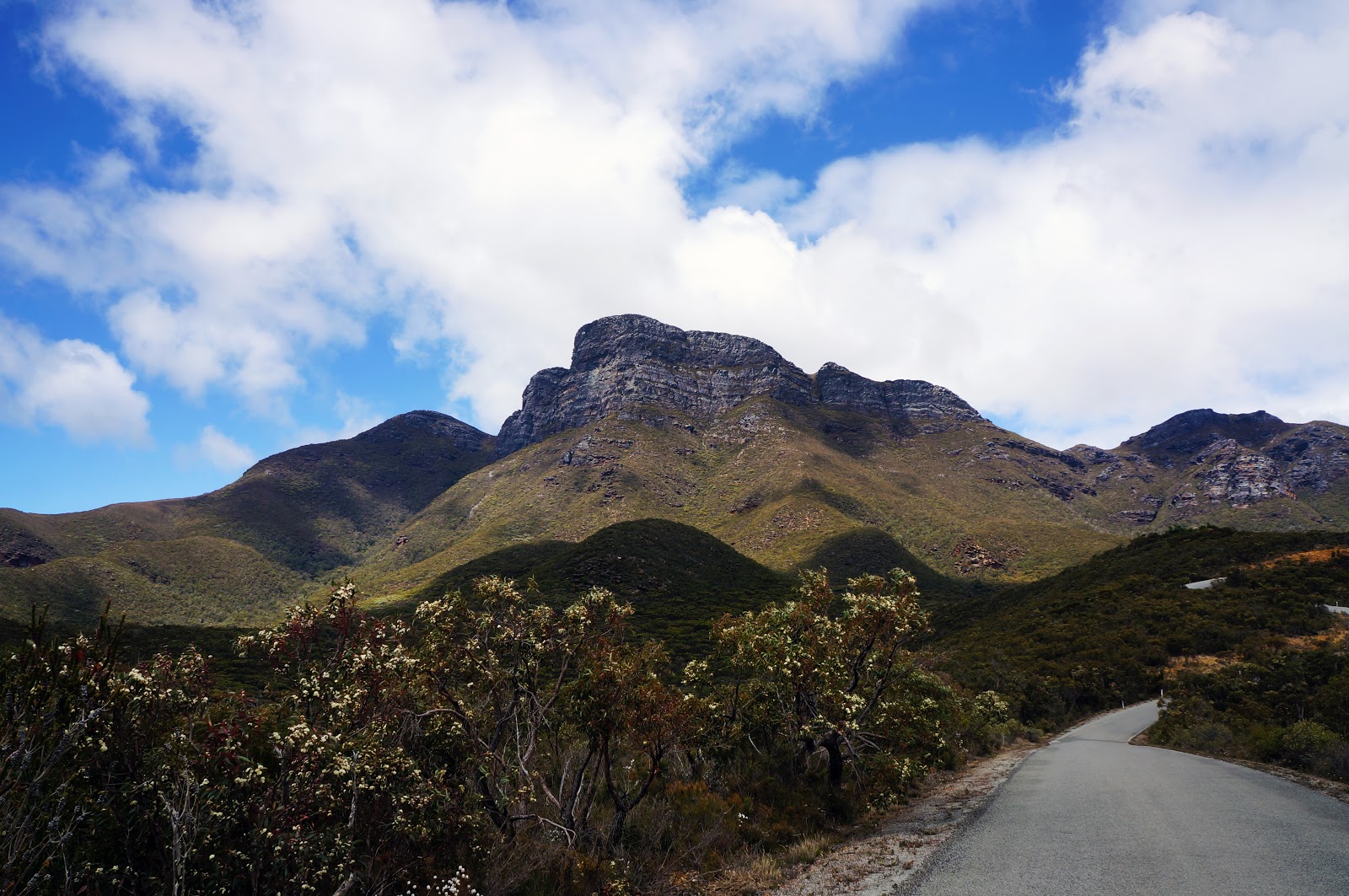
After a relatively easy morning stroll on the Woylie Walk in the Dryandra Woodlands, Alissa and I hopped into the car for the next stop of our weekend Down South - Bluff Knoll in Stirling Range National Park. Our plan was for a fairly relaxed arrival at Moingup Springs to suss out where to set up our tent, a warm up walk up Mt Hassell and then time our visit to be at the summit of Bluff Knoll nearer to sunset. As we reached the intersection of Formby and Chester Pass Rds, I saw Bluff Knoll and the Eastern Peaks were clearly visible and not engulfed in clouds. With clouds rolling around to the south west, I thought it might be better to head straight for Bluff Knoll and take the gamble that the weather would hold up rather than risk the chance of zero visibility later in the day.
Arriving at the Bluff Knoll car park, Alissa and I hopped out of the car to find the weather to be very cold - a situation exacerbated by fairly strong winds. Usually, Alissa and I tough it out in the cold for the first fifteen minutes of a walk as by then we usually get warm enough, but the wind chill factor lead to us rugging up as soon as we got out of the car.

From the car park, the trail initially follows a metal boardwalk to a large interpretative panel and bench seating. This area serves as an excellent look out point for those who aren't able to actually do the walk, as well as providing interesting information about Bluff Knoll and the Stirling Range in general.

From the boardwalk, the trail descends a set of stairs and follows a bitumenised path for the first few hundred metres. As luck would have it, clouds that were blocking the Sun parted as we walked this section, providing us with much needed warmth and once again shining a light on the mountain's unmistakable sheer cliff face.

The bitumen path thankfully does not last long, and walkers will soon encounter the first steps of the ascent. With some rare exceptions, these steps run almost continuously from here all the way to the saddle between Bluff Knoll and the neighbouring Coyanarup Peak.

Beyond the mountain peaks, what makes the Stirling Range such a special place is its incredible biodiversity. The place is a botanist's dream in Springtime, and there were many Mountain Bells in bloom right along the walk trail.

Like Toolbrunup Peak, the first part of the walk is surprisingly forested however there are a number of points along this early stage of the walk where the canopy opens up to reveal spectacular views of Bluff Knoll's summit looming overhead.

A break in the continuous steps occurs around the 1 kilometre mark as the trail passes through an area of talus that was fairly firm under foot. Although rocky, this short stretch of track was fairly easy going - especially when compared to the loose scree and the boulder field scrambling required to climb Toolbrunup.

As with all the other mountains in the Stirling Range, many of the rocks feature ripple-like grooves that bear witness to the fact that the rocks that now make up the mountain range were once sedimentary layers of a shallow sea.

At the top of the stretch through talus, walkers will encounter Bluff Knoll's waterfall. It is a fairly small but pretty waterfall, and makes for a nice feature during this early part of the ascent.

Just beyond the waterfall, the track turns right and ascends steeply up the side of the mountain. Although the provision of steps makes this relatively straightforward when compared to Toolbrunup and Talyuberlup, this is the more strenuous section of the walk and walkers should be aware that there are number of times along this stretch where there are sheer drops just to the right of the track. Its all very safe and tourist friendly, but just because this is not a scramble doesn't mean you should switch off completely either.

All along the ascent are markers counting down the distance to the summit. This alternates between being reassuring and demoralising, and in the case of the 1.6 kilometre marker it was definitely the latter. The first kilometre of the walk passed by in no time at all but the 400 metres from just before the waterfall to this point seemed like an eternity of endless step climbing.

Although slow going and in fairly cold winds, I can say that we were at least blessed by a lack of cloud cover, providing excellent views across the range with the towering peak of Toolbrunup visible in the distance and Mt Trio to the near right.

Being such a popular tourist climb, some sections of the track have become severely eroded, and decking has been put in place to ensure the walk is still safe. With me having slipped on wooden decking along the Luke Pen Walk and Alissa having slipped on a board a few weeks earlier on the Bibbulmun Track, we definitely advise walkers to always approach these decks with caution - especially in wet weather.

As the track continues to rise relentlessly, the landscape becomes increasingly rugged, with the track passing by large rocky outcrops along the way.


As the trail curves around the mountain at the 2 kilometre mark, a view of the car park provides walkers with a sense of just how high up they have travelled so far.

As the track passes the saddle between Bluff Knoll and Coyanarup Peak, the track shows signs of erosion similar to the other less tourist friendly mountains in the range. From here the track become less steep, however the lack of a wind break creates a new challenge in the form of intensely strong winds. The winds were so strong Alissa feared that she might be blown over, and the temperature -which was already in the mid to low teens - feel like 6-8°C with the wind chill factor added!

From the top of the saddle, the summit of Coyanarup Peak provides a lovely outlook, with the western peaks providing a stunning backdrop. From here the track continues to curve left as it crosses the top of the mountain towards the summit.

The montane vegetation across the top of the peak provided for a change of pace, although there were not a lot of wildflowers out at this level. I've read that the flower displays higher up Bluff Knoll and Toolbrunup Peak are at their best in Summer, and I'm sure that Dieback has played a major role in the less brilliant wildflower display. We were however pleasantly surprised by the sound of frogs in a swampy section to the right of the track, a class of animals we would not have picked to be living in this harsh environment.

As we walked across the top of the mountain, our timing could not have been better to witness the patchwork of light and shade created by the clouds as they moved rapidly over the landscape.

The track dips down briefly on the way to the summit, and there seemed to be a few more wildflowers in the area, presumably due to being a little more sheltered.


As the track rises one last time, a marker indicated that the Summit is only 100 metres away.

Unlike the obvious peak of Toolbrunup and the scramble required to reach Tayluberlup's summit, Bluff Knoll's is a bit of a non-event and there is not even a cairn to mark this final spot. The sign pictured above had been vandalised as the sticker that used to indicate that we had reached the summit had been ripped off by another less considerate walker some time in the past, only adding to the anti-climax.
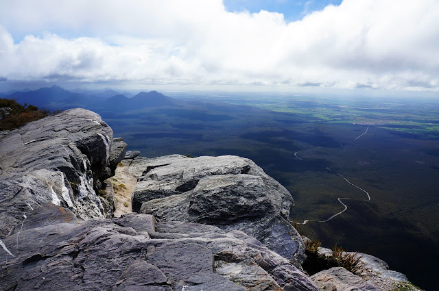
However, once over the summit, walkers can descend to a ledge along the top of a cliff that provides for some spectacular views - just don't get to close to the edge! The view north-west takes in the western peaks and the farmland just beyond the National Park boundary.

Bluff Knoll's greatest asset however is the view to the north-east, with the eastern peaks that make up the Stirling Ridge Walk clearly visible. Just beyond and below is the excellently named Moongoongoonderup Hill, followed by the high ridge from Isongerup Peak, the Three Arrows, Baker's Knob, Pyungoorup and Ellen Peak. Being privy to this stunning but rugged landscape only strengthened my resolve to complete the Ridge Walk, hopefully in Spring 2017 and after a bit more training.

Walkers retrace their steps back to the car park for the return journey. As we were walking across the top of Bluff Knoll, whispy clouds began to roll over the mountain, and by the time we reached the saddle of Coyanarup Peak, the western peaks were no longer visible. The Stirling Range's famously changeable weather became a major feature of the descent, and we had everything from sunny to cloudy to rain to hail over an hour-long period (sadly, no snow).

Back at the car park, we were privy to one final incredible view of Bluff Knoll almost completely engulfed in clouds. Having had such clear visibility during our ascent, Alissa was glad that we followed my gut instinct to tackle Bluff Knoll earlier rather than later. If we had waited an hour or more, this would have been a very different series of photographs and a much less fulfilling experience indeed.
Being the tallest mountain in the South West (though not even the third tallest mountain Western Australia as some claim), it is obvious why Bluff Knoll is so popular with tourists; its great to be able to say you've climbed the highest peak in any given area, and the well maintained trail to the summit makes it accessible to a large percentage of the population. Being part of the eastern peaks ridge, Bluff Knoll is uniquely well positioned to provide excellent views across to Ellen Peak, and it remains the most memorable image of this walk for me.
That being said, Alissa and I agreed that the walk up Bluff Knoll was less fun than the journey up Toolbrunup or Talyuberlup. The fact that Toolbrunup and Talyuberlup require scrambling and some minor problem solving make them much more engaging mountains to summit, whereas the continuous step climb of Bluff Knoll can become a bit monotonous in comparison. As such, Bluff Knoll falls a bit short of being one of my absolute favourite walks in WA, but it is nevertheless worth tackling - whether as a tough but relatively accessible peak in a beautiful part of the state, or as a reconnaissance mission for those wanting to start planning a traverse of the Stirling Ridge Walk.

After a relatively easy morning stroll on the Woylie Walk in the Dryandra Woodlands, Alissa and I hopped into the car for the next stop of our weekend Down South - Bluff Knoll in Stirling Range National Park. Our plan was for a fairly relaxed arrival at Moingup Springs to suss out where to set up our tent, a warm up walk up Mt Hassell and then time our visit to be at the summit of Bluff Knoll nearer to sunset. As we reached the intersection of Formby and Chester Pass Rds, I saw Bluff Knoll and the Eastern Peaks were clearly visible and not engulfed in clouds. With clouds rolling around to the south west, I thought it might be better to head straight for Bluff Knoll and take the gamble that the weather would hold up rather than risk the chance of zero visibility later in the day.
Arriving at the Bluff Knoll car park, Alissa and I hopped out of the car to find the weather to be very cold - a situation exacerbated by fairly strong winds. Usually, Alissa and I tough it out in the cold for the first fifteen minutes of a walk as by then we usually get warm enough, but the wind chill factor lead to us rugging up as soon as we got out of the car.
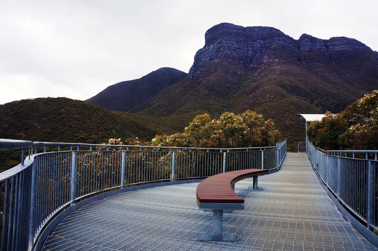
From the car park, the trail initially follows a metal boardwalk to a large interpretative panel and bench seating. This area serves as an excellent look out point for those who aren't able to actually do the walk, as well as providing interesting information about Bluff Knoll and the Stirling Range in general.

From the boardwalk, the trail descends a set of stairs and follows a bitumenised path for the first few hundred metres. As luck would have it, clouds that were blocking the Sun parted as we walked this section, providing us with much needed warmth and once again shining a light on the mountain's unmistakable sheer cliff face.

The bitumen path thankfully does not last long, and walkers will soon encounter the first steps of the ascent. With some rare exceptions, these steps run almost continuously from here all the way to the saddle between Bluff Knoll and the neighbouring Coyanarup Peak.

Beyond the mountain peaks, what makes the Stirling Range such a special place is its incredible biodiversity. The place is a botanist's dream in Springtime, and there were many Mountain Bells in bloom right along the walk trail.

Like Toolbrunup Peak, the first part of the walk is surprisingly forested however there are a number of points along this early stage of the walk where the canopy opens up to reveal spectacular views of Bluff Knoll's summit looming overhead.

A break in the continuous steps occurs around the 1 kilometre mark as the trail passes through an area of talus that was fairly firm under foot. Although rocky, this short stretch of track was fairly easy going - especially when compared to the loose scree and the boulder field scrambling required to climb Toolbrunup.

As with all the other mountains in the Stirling Range, many of the rocks feature ripple-like grooves that bear witness to the fact that the rocks that now make up the mountain range were once sedimentary layers of a shallow sea.

At the top of the stretch through talus, walkers will encounter Bluff Knoll's waterfall. It is a fairly small but pretty waterfall, and makes for a nice feature during this early part of the ascent.

Just beyond the waterfall, the track turns right and ascends steeply up the side of the mountain. Although the provision of steps makes this relatively straightforward when compared to Toolbrunup and Talyuberlup, this is the more strenuous section of the walk and walkers should be aware that there are number of times along this stretch where there are sheer drops just to the right of the track. Its all very safe and tourist friendly, but just because this is not a scramble doesn't mean you should switch off completely either.

All along the ascent are markers counting down the distance to the summit. This alternates between being reassuring and demoralising, and in the case of the 1.6 kilometre marker it was definitely the latter. The first kilometre of the walk passed by in no time at all but the 400 metres from just before the waterfall to this point seemed like an eternity of endless step climbing.

Although slow going and in fairly cold winds, I can say that we were at least blessed by a lack of cloud cover, providing excellent views across the range with the towering peak of Toolbrunup visible in the distance and Mt Trio to the near right.

Being such a popular tourist climb, some sections of the track have become severely eroded, and decking has been put in place to ensure the walk is still safe. With me having slipped on wooden decking along the Luke Pen Walk and Alissa having slipped on a board a few weeks earlier on the Bibbulmun Track, we definitely advise walkers to always approach these decks with caution - especially in wet weather.

As the track continues to rise relentlessly, the landscape becomes increasingly rugged, with the track passing by large rocky outcrops along the way.


As the trail curves around the mountain at the 2 kilometre mark, a view of the car park provides walkers with a sense of just how high up they have travelled so far.
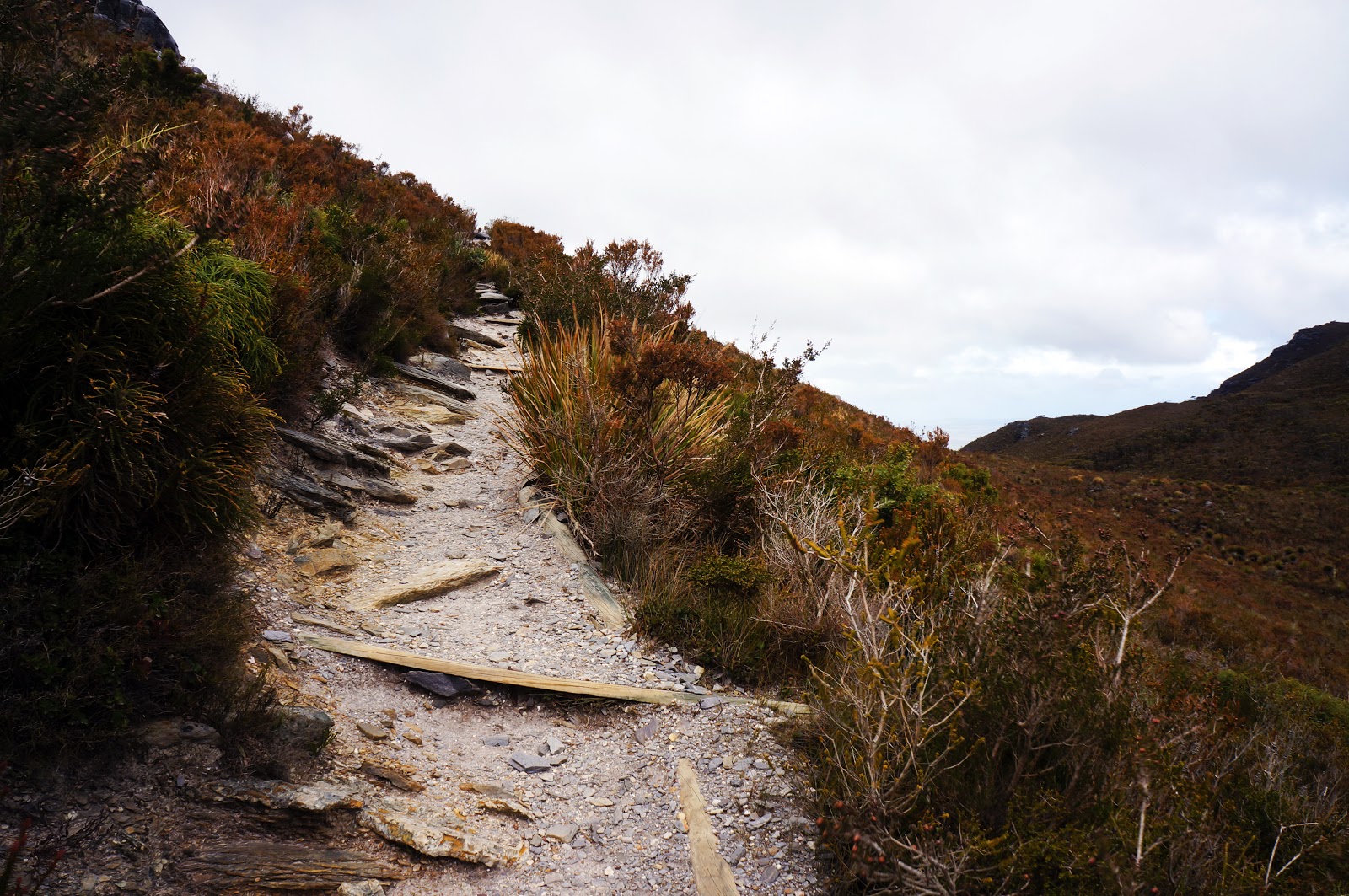
As the track passes the saddle between Bluff Knoll and Coyanarup Peak, the track shows signs of erosion similar to the other less tourist friendly mountains in the range. From here the track become less steep, however the lack of a wind break creates a new challenge in the form of intensely strong winds. The winds were so strong Alissa feared that she might be blown over, and the temperature -which was already in the mid to low teens - feel like 6-8°C with the wind chill factor added!

From the top of the saddle, the summit of Coyanarup Peak provides a lovely outlook, with the western peaks providing a stunning backdrop. From here the track continues to curve left as it crosses the top of the mountain towards the summit.

The montane vegetation across the top of the peak provided for a change of pace, although there were not a lot of wildflowers out at this level. I've read that the flower displays higher up Bluff Knoll and Toolbrunup Peak are at their best in Summer, and I'm sure that Dieback has played a major role in the less brilliant wildflower display. We were however pleasantly surprised by the sound of frogs in a swampy section to the right of the track, a class of animals we would not have picked to be living in this harsh environment.

As we walked across the top of the mountain, our timing could not have been better to witness the patchwork of light and shade created by the clouds as they moved rapidly over the landscape.

The track dips down briefly on the way to the summit, and there seemed to be a few more wildflowers in the area, presumably due to being a little more sheltered.


As the track rises one last time, a marker indicated that the Summit is only 100 metres away.

Unlike the obvious peak of Toolbrunup and the scramble required to reach Tayluberlup's summit, Bluff Knoll's is a bit of a non-event and there is not even a cairn to mark this final spot. The sign pictured above had been vandalised as the sticker that used to indicate that we had reached the summit had been ripped off by another less considerate walker some time in the past, only adding to the anti-climax.

However, once over the summit, walkers can descend to a ledge along the top of a cliff that provides for some spectacular views - just don't get to close to the edge! The view north-west takes in the western peaks and the farmland just beyond the National Park boundary.
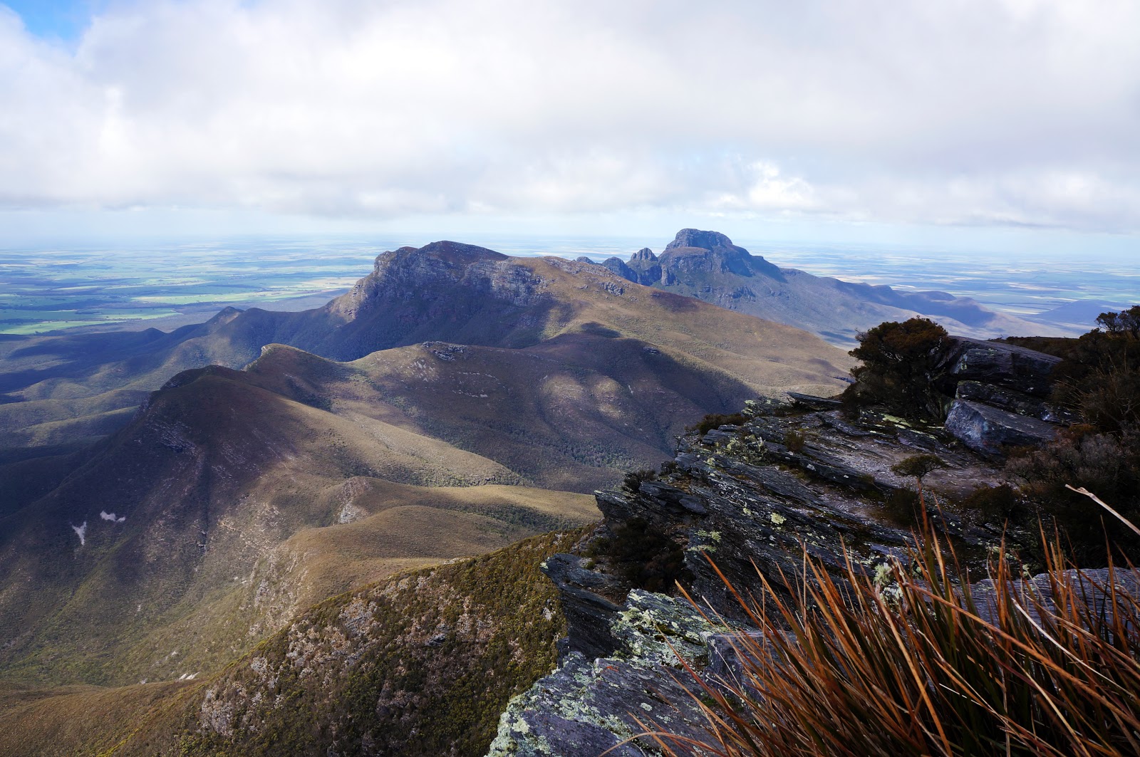
Bluff Knoll's greatest asset however is the view to the north-east, with the eastern peaks that make up the Stirling Ridge Walk clearly visible. Just beyond and below is the excellently named Moongoongoonderup Hill, followed by the high ridge from Isongerup Peak, the Three Arrows, Baker's Knob, Pyungoorup and Ellen Peak. Being privy to this stunning but rugged landscape only strengthened my resolve to complete the Ridge Walk, hopefully in Spring 2017 and after a bit more training.

Walkers retrace their steps back to the car park for the return journey. As we were walking across the top of Bluff Knoll, whispy clouds began to roll over the mountain, and by the time we reached the saddle of Coyanarup Peak, the western peaks were no longer visible. The Stirling Range's famously changeable weather became a major feature of the descent, and we had everything from sunny to cloudy to rain to hail over an hour-long period (sadly, no snow).

Back at the car park, we were privy to one final incredible view of Bluff Knoll almost completely engulfed in clouds. Having had such clear visibility during our ascent, Alissa was glad that we followed my gut instinct to tackle Bluff Knoll earlier rather than later. If we had waited an hour or more, this would have been a very different series of photographs and a much less fulfilling experience indeed.
Being the tallest mountain in the South West (though not even the third tallest mountain Western Australia as some claim), it is obvious why Bluff Knoll is so popular with tourists; its great to be able to say you've climbed the highest peak in any given area, and the well maintained trail to the summit makes it accessible to a large percentage of the population. Being part of the eastern peaks ridge, Bluff Knoll is uniquely well positioned to provide excellent views across to Ellen Peak, and it remains the most memorable image of this walk for me.
That being said, Alissa and I agreed that the walk up Bluff Knoll was less fun than the journey up Toolbrunup or Talyuberlup. The fact that Toolbrunup and Talyuberlup require scrambling and some minor problem solving make them much more engaging mountains to summit, whereas the continuous step climb of Bluff Knoll can become a bit monotonous in comparison. As such, Bluff Knoll falls a bit short of being one of my absolute favourite walks in WA, but it is nevertheless worth tackling - whether as a tough but relatively accessible peak in a beautiful part of the state, or as a reconnaissance mission for those wanting to start planning a traverse of the Stirling Ridge Walk.


Hi AlissaandDon. I've been enjoying your Bibbulmun series. The Ridge Walk is a great walk, the scrambling is all pretty straight forward, the section around First Arrow is probably the hardest bit. I've written up the Hollow Mountain - Mt Stapylton traverse that you were asking about if you want to check it out. If you manage that traverse you'll do the Ridge Walk without much trouble!
ReplyDeleteHi Kevin, thanks for the feedback and info. I'm really looking forward to the Ridge Walk as I've wanted to do it for a very long time. I've been pretty busy of late and hadn't kept up with your blog recently, but I've just read about that Hollow Mountain-Stapylton Traverse and I'm very impressed!
Delete