
The second day of an overnight hike on the Bibbulmun Track, this 21.3 km double hut section of the track takes walkers from Waalegh to the Perth Hills Discovery Centre via Helena and Ball Creek. Though continuously hilly, walkers are rewarded by some of the most spectacular valley views in the Darling Scarp section of the track. With beautiful Granite formations, creeks and a small waterfall, this is one of the Bibbulmun's best.
Distance: 21.3 km (one way)
Gradient: Continuously hilly over the entire day, with some flat sections
Quality of Path: Largely clear and well maintained.
Quality of Signage: Largely well signed, with the Waugal providing very clear directional information.
Experience Required: Some Bushwalking Experience Recommended
Time: 7 Hours, including lunch and a snack break
Steps: Some formal steps, as well as informal ones amongst rocky outcrops
Best Time to Visit: Winter-Spring
Entry Fee: No
Getting There: Access is via the Perth Hills Discovery Centre, located on Allen Rd. The turn off for the Centre is at the roundabout intersection with Mundaring Weir Rd. Entry Fee: No
After a lovely chat huddled around the camp fire following our walk from Dale Rd to Waalegh, I had the best sleep I've ever had on the Bibbulmun Track. I'm not sure if it was the fact I'd slept less than 5 hours the night before or if it was courtesy of our newly completed Sea to Summit sleep systems, but I apparently fell asleep almost immediately and didn't have the restless night of tossing and turning I've come to expect from at least the first night out on the track.

Although cloudy, waking up to the view from Waalegh was a great way to start what proved to be a somewhat lazy morning. Usually, I like to eat breakfast, get packed and on the road in under an hour, however walking with Life of Py's walking group inevitably meant being pragmatic, with people rising at various different times and a bit longer spent at the campsite. Not that we minded really - not every campsite along the track is as excellent as Waalegh is and it is worth savouring.

The later departure at Waalegh afforded me some time to have breakfast overlooking the valley, and take in the beauty of the area for just a bit longer.
At 21.3 km, the double hut from Waalegh to the Perth Hills Discovery Centre is considerably longer and hillier than Dale Rd to Waalegh, and as such it was nice that the day's walk started gently with a relatively easy downhill section that featured more views across the Helena Valley.

As we came to the bottom of the first descent, there was an obvious change in vegetation, and one wildflower was in abundance. I'm usually pretty terrible when it comes to wildflower names, but I knew this one - the Yanchep Rose. I'd seen photos of it online and knew it as the namesake flower of a trail in Yanchep National Park, however I had never timed my visit to Yanchep at the same time these flowers were in bloom. Seeing them on the Bibbulmun was a welcome treat, and it was especially nice to see them in such profusion.

At the bottom of the first descent were a number of small watercourses, one of which I incorrectly thought was the unfortunately named Chinaman's Gully. Although we would indeed cross Chinaman's Gully later along the walk, the slightly racist connotation of the gully's name was not lost on the group. Simon, one of our fellow hikers, immediately quipped 'what century are we in again?' given that the name has definitely not aged well.

After a moderate ascent, the track returns to a gentle, slow descent as it leads to the Helena River itself.

The walk through fairly open, mature Wandoo Woodlands is really lovely, especially since the openness affords walkers continuous valley views beyond the trees. Wandoo and the closely related Powderbark would be a near constant companion for much of the walk to Helena, and largely contributed to the lovely scenery along this stretch of track.

The trail reaches an old vehicle track near the bottom of the descent, leading to the Allen Road Bridge over the Helena River.

After crossing the bridge, the trail leaves the road to ascend steeply up a series of steps.

This was arguably the steepest ascent of the day. and caused the group to split in two, with one half continuing on along the track while the other stopped for a rest just after the ascent.

Myself and Mark (the leader of the expedition and the blogger behind the Life of Py), were near the front, affording both of us an opportunity to take as many photos as we liked while waited for the group to catch up to us.

I walk with trekking poles and have become slightly paranoid about falling over after spraining my wrist twice this year, so I was very impressed to see Mark (of Life of Py fame)'s confidence and surefootedness as he walks constantly with a camera in one hand. It was also nice to chat with Mark in person, as most of our discussions have been via social media platforms.

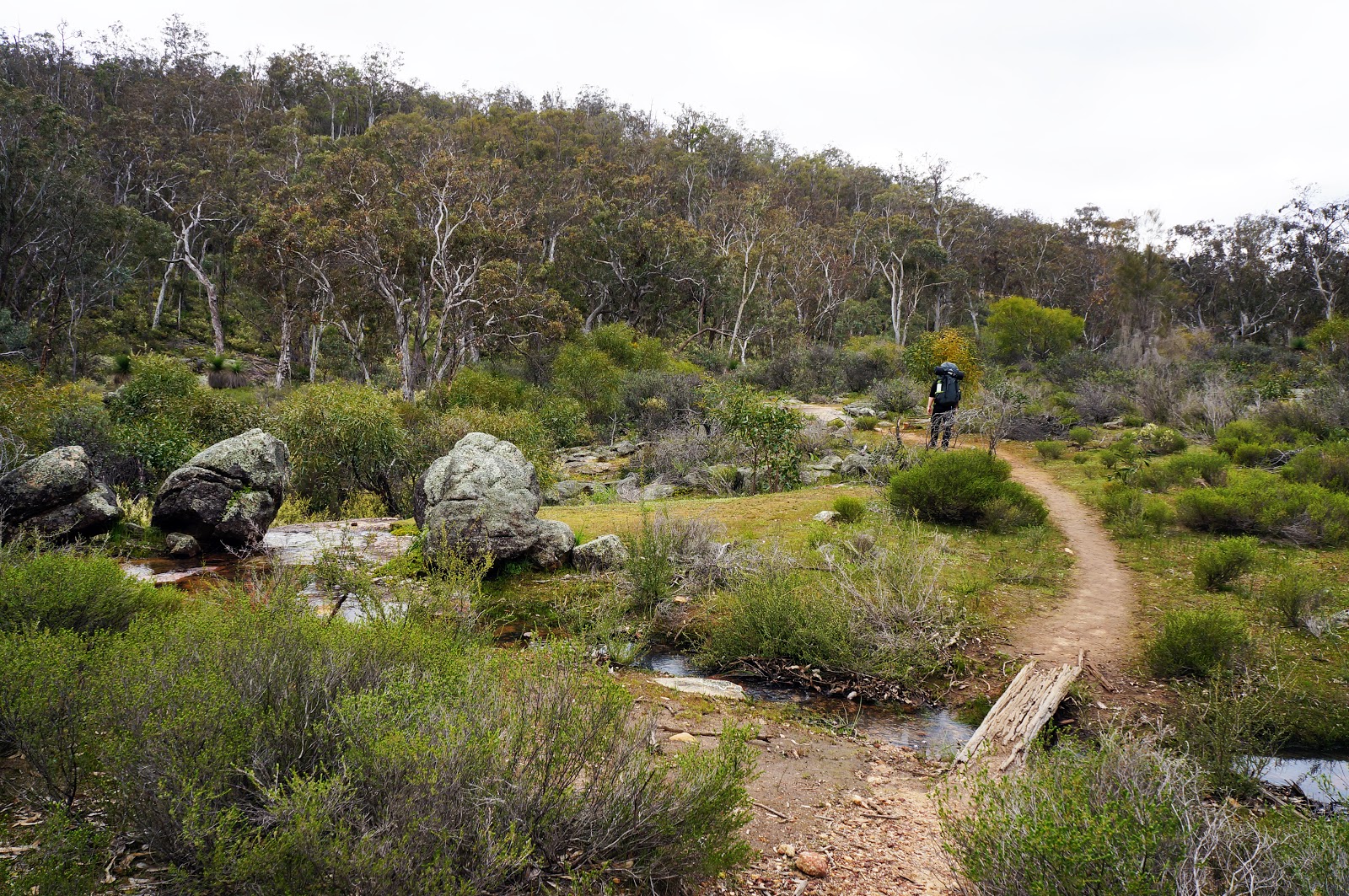
After the rest of the group caught up, we descended once again and reached the actual Chinaman's Gully. As we were descending, Mark and I were eyeing off the conspicuous granite outcrops on the other side of the valley. We were both pretty keen to walk through something like that, and I joked we could make a 'Class 6 detour' straight up the steep valley and climb through the rocks. Thankfully we got our wish without the detour; as we ascended the valley, the trail veered left and took us through a rocky granite ridge.

This was one of my favourite sections of the day, with beautiful wildflowers complementing the beauty of the granite.

The views form here were excellent, once again offering us valley views beyond the granite formations we were walking through.


After the granite ridge, the track turns right onto an old vehicle track named Driver Rd as it leads to Helena hut.

A spur trail descends to Helena, the last of the Beraking-Waalegh-Helena triumvirate of Bibbulmun Track huts that are perched high over the Helena Valley. As we were double hutting, we would not be staying at Helena. However, its excellent vantage point was the perfect spot for our lunch break.

Helena is an example of the 'Stretch' style of Bibbulmun Track hut, being a bit bigger than Waalegh thanks to each bunk being wide enough to sleep three. The 'Stretch' huts are fairly uncommon along the track, with most huts either going for the 8-person 'Standard configuration of Waalegh or the substantially larger 'Deep South' style hut like at Beraking.

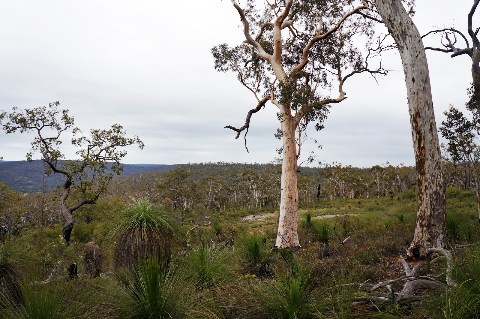
Like Waalegh, Helena campsite is one of the highlights of the Track and is surrounded by beautiful Wandoo Woodlands, and the area has many unique features. One such feature is a granite rock near the hut that forms a natural stone couch from which to view the Helena Valley.

A small path leads down from the hut to a large granite slab with superb views of the Helena Valley below.

After lunch at such a pretty campsite, it was a bit cruel having to rise up again back to the trail, however the terrain from here to the next hut - Ball Creek - was considerably gentler than the journey from Waalegh to Helena. Early on, we passed an area with large, exposed granite rocks.

As we got closer, we saw a lot of disturbing signs that people had wilfully ignored Bibbulmun Track rules and Leave No Trace principles, and had ridden dirt bikes over the rock, ripping up the soil and leaving tyre trails over the area. Worse still, the campers left food scraps everywhere, with lollies and chips just blatantly left behind, and even a pile of sausages thrown into the bushes. Considering the twelve of us had walked in with all our gear on our backs and were taking all our rubbish out with us, such blatant disregard for Leave No Trace principles really irked me - especially since they even had a vehicle to transport and we were on foot!
"Its a completely different mindset," Mark said with some consternation, and he was absolutely right.

From there, the trail heads through a mix of Jarrah and Wandoo. Much of the area was filled with wildflowers, making the walking engaging even without the excellent views seen earlier. From the water tank pictured above, the trail descends steeply as it leads to Mann's Gully.

Here's Didier - an accomplished Bibbulmun Track End to Ender also known as Magpie - providing some comic relief during the descent.

Once at the bottom, the track crosses a number of creeks before entering an area filled with stunning granite outcrops and open Wandoo Woodlands. The walking for the next kilometre is almost uniformly excellent, and some of the best of what the Darling Scarp section of the track has to offer.

The lushness of the area is definitely helped by its close proximity to Mann's Gully, with the Bibbulmun running alongside the gully before crossing it.
Not long after crossing the gully for the first time, the Bibbulmun crosses over yet again at the wooden plank pictured above. To the left, the gully flows down a small waterfall - a rare sight along the Bibbulmun in general. Unfortunately, walking this section in early Spring meant that the waterfall's flow had reduced to the point that its beauty was slightly marred by a build up of algae, and I didn't bother photographing it. As with much of the Darling Scarp, it is always a toss up between seeing the waterfalls in mid to late Winter or the wildflowers of Springtime - it is very hard to time it for both.

The track crosses a large granite outcrop, with the gully flowing along a section of the rocks. Nearby is a Water Corporation gauging station - a part of which looks like a zip-line across the gully (I'm sure its not, so don't try it!). From here the track ascended through Jarrah and Yarri forest as it lead to Ball Creek campsite.

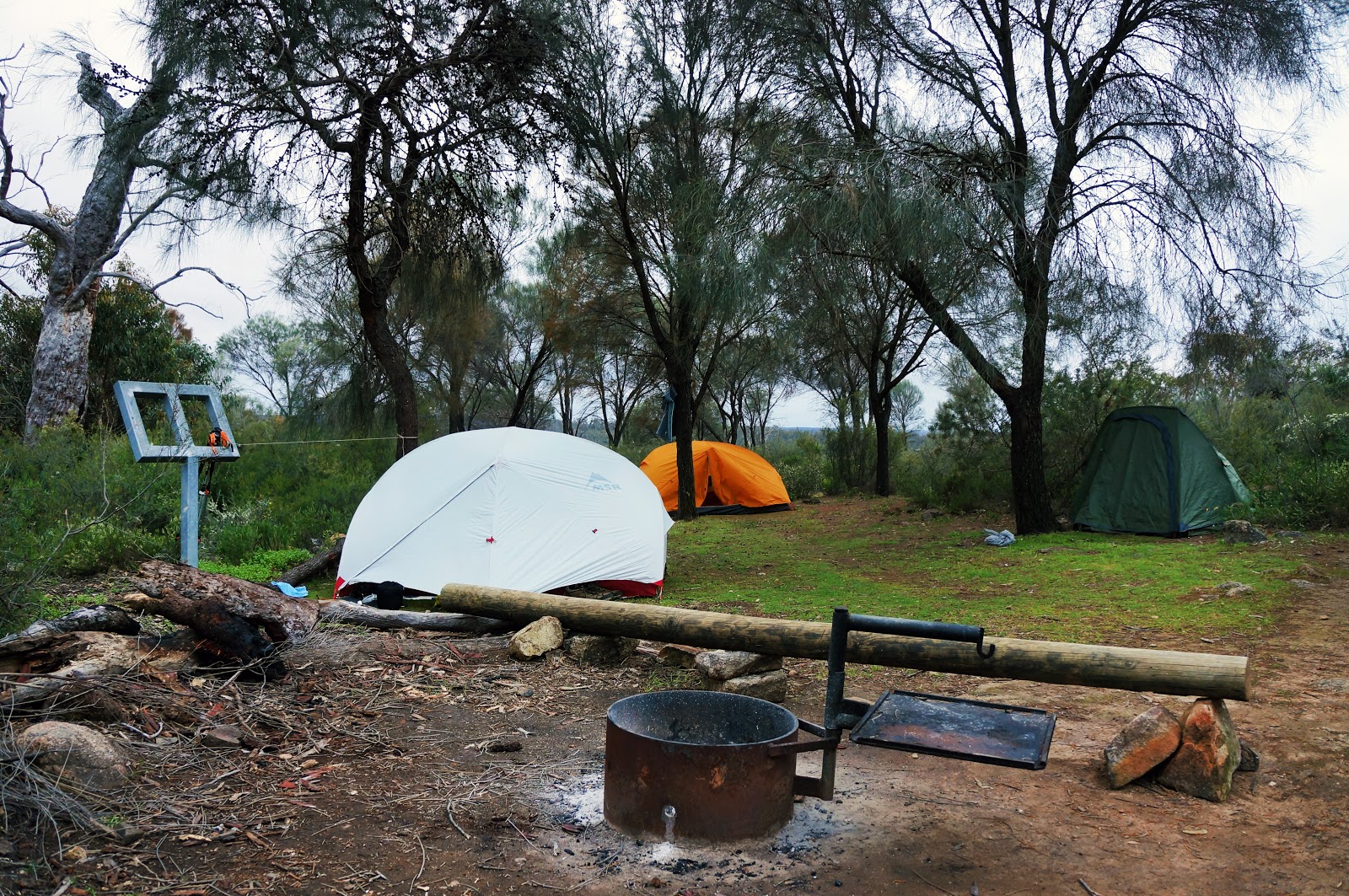
With Ellie and Mitch leading the way, the group pushed on to Ball Creek, the last hut of our overnight hike. The last time Alissa and I were at Ball Creek was in June 2015, and at the time Ball Creek itself was dry, with the area looking rather dull and grey. It really goes to show what a difference a good bit of rain can do, as the campsite looked a lot more attractive in the Springtime.

Ball Creek is a small hut of the 'Standard' configuration, although it has some interesting and very non-standard features.

Some huts along the track feature books but Ball Creek's collection is next level, with two shelves of books to provide walkers with reading material. Being a short stay, we only had time for a quick snack and didn't get a chance to read anything. Its only 2.6 kilometres from Ball Creek to the Perth Hills Discovery Centre, and we were ready to get it completed.

Simon and Emma lead the way through the somewhat uneventful Jarrah forests between Ball Creek and our final destination. It was far from the best walking of the day, but it was pleasant enough. Last time Alissa and I walked this section, there were information signs telling walkers about the importance of controlled burns that had been graffitied with smart ass comments by someone who obviously disagreed with the policy. DPaW had obviously removed the signs in the interim, however they had clearly left an impression for those who passed them, as Mark, Ellie and Mitch all recalled the signs as well.

Just before reaching the car park, the Bibbulmun passes by a boot cleaning station. Although we had basically come from a relatively Dieback free area and the importance of the cleaning station is more for those heading from the Discovery Centre through to Ball Creek and beyond, we all did the right thing and scrubbed any mud and excess soil from our shoes. Please take these seriously - Dieback is a real problem in Western Australia and we can all do our part to help stop its spread.

The car park was then not even 100 metres away, taking us to where our adventure began the day before. After getting a lift back to the cars parked at Dale Rd we all went our separate ways, tired but feeling accomplished after an excellent weekend.
Though Dale Rd to Waalegh was definitely enjoyable, the walk from Waalegh to the Perth Hills Discovery Centre was even better - I would even go as far as to say this double hut section would rank as one of my personal favourites along the track so far. There are quite a few pleasant but not exactly amazing sections of the Bibbulmun from Kalamunda to North Bannister (the Monadnocks and Mt Cooke notwithstanding), especially when compared to the stunning Karri and Tingle forests and the coastal sections of the Southern Half. This Wandoo-dominated section really held up well however, and in its own way Waalegh to the Discovery Centre was just as beautiful and spectacular as any of the track's best days. Perth is seriously lucky to have such a lovely stretch of the track so close to the city. Although this was a long day of walking, I would encourage anyone looking to get into overnight hiking to give the two day hike from Dale Rd to the Discovery Centre a go.


This is a terrific post dear, really love what you have shared.. couldnt get enough of it.. Please keep us posted with more and i will check back again.
ReplyDelete