

An underrated trail in Wellington National Park, the Jabitj (running water) Trail links Wellington Dam Kiosk with the superb campgrounds at Honeymoon Pool. Utilising a stretch of the old Bibbulmun Track, the trail follows the beautiful Collie River, providing lovely views of rocky rapids, moss covered granite boulders and lush forest. A surprisingly excellent trail, this is a perfect walk for a weekend away from Perth.
Distance: 6 km (one way)
Gradient: Generally flat, with some moderate inclines.
Quality of Path: Clear and straightforward, though some sections are mildly overgrown
Quality of Signage: Very informative trailhead. Very well signed with green markers throughout
Experience Required: No previous Bushwalking Experience Required
Time: 1.5 Hours
Steps: Some informal steps over rocks as well as formal steps along the boardwalk at the end of the track
Best Time to Visit: Autumn-Spring
Best Time to Visit: Autumn-Spring
Entry Fee: No
Getting There: Access is via either Wellington Dam Rd near the Dam Kiosk, or at Honeymoon Pool via River Rd. Both are off Coalfields Hwy, with turn offs for both Wellington Dam and Honeymoon Pool very well signed. 
Our Bibbulmun Track plans for the rest of 2016 had been to complete the Collie to Balingup section of the track, as well as redoing the Denmark to Albany stretch since we had not really photographed it in 2012. While the long, wet Winter had been a boon over the hiking season, it inevitably lead to a shorter timeframe for DPaW to undertake their controlled burns. As such, Collie to Balingup had been diverted at three points along its route, and we decided to instead do the section from Harvey-Quindanning Rd to Harris Dam. Heading down to Wellington National Park to camp at Potters Gorge on the Friday night, it became pretty clear that this plan was going to have to be shelved too, as Alissa's back problems started to flare up again. Very sore and not fit to do the Bibbulmun Track overnight, Alissa suggested that I should complete one of the day hikes in Wellington National Park to at least make the most of our time in the area and she would pick me up at the end.

Wellington National Park is well known as a mecca for cyclists and vehicle-based camping, however I had not heard anyone talk about the walk trails in the area other than the Bibbulmun Track's Wellington Spur Trail, and that sections of the old 1988 alignment of the Bibbulmun Track had been converted to dual use cycle trails. I was thus surprised to read about the Jabitj Trail, a 6 kilometre one way walk that starts near the Wellington Dam Kiosk and continues on to Honeymoon Pool. An interesting walk over a decent enough length, it seemed like the best option given that the Wellington Spur Trail was also diverted due to controlled burns!

The Wellington Dam Kiosk is an old heritage listed building located high above the Collie River Valley, and as such the trail immediately descends to reach the river. The walking was immediately pleasant, passing through fairly lush Jarrah forest. The trail is well marked with obvious green markers and was surprisingly well maintained for a trail that is not on the Trail WA website at the time of writing.

After crossing the road to the dam once, the trail reaches the road again at the dam's pumping station.

Although not part of the trail, walking down the road to see the dam wall is well worth the side trip. Wellington Dam is apparently also a hydroelectric power station, and the water spurting out the front of the dam and filling the Collie River answered my biggest question about this walk - how could a walk downstream of a dam still have water at this time of year?

From the pumping station, green markers show the Jabitj Trail initially running alongside a pipeline before veering left to follow the river.

Immediately, I was taken by how beautiful the Collie River Valley was. I tend to discount November as prime wildflower walking due to the encroaching heat, however there were a lot of late blooming wildflowers along the river - many which I'd not seen at all over this year's wildflower season.

Although initially looking like a vehicle track, the trail narrows to a purpose built walk trail and runs right along the river. As I came around a corner and saw the view pictured above, I literally said 'wow' out loud. The prettiness of the river views were something of a surprise as I'd never even heard of this walk before looking it up on Friday night. How on Earth did a purpose built walking trail with such excellent views come to be in this area?

I suspected a Bibbulmun connection, and this suspicion was confirmed as I continued on. Albeit having grown far beyond a reasonable eye level height, Waugal trail markers could be seen nailed to several trees along the walk, revealing that this trail had once been a part of the old Bibbulmun Track before the realignment in 1998. Consulting my copy of the 1988 guidebook, I could see that this section had been part of Stage 16, leading hikers to a campground known as The Ferns with the option to continue to Honeymoon Pool.

Continuing along the trail, I was greeted by even more wildflowers including many fine examples of the Yanchep Rose. This section of the trail was very lush and quite similar to Bibbulmun Track sections near Dwellingup such as Swamp Oak and Yarragil Form.

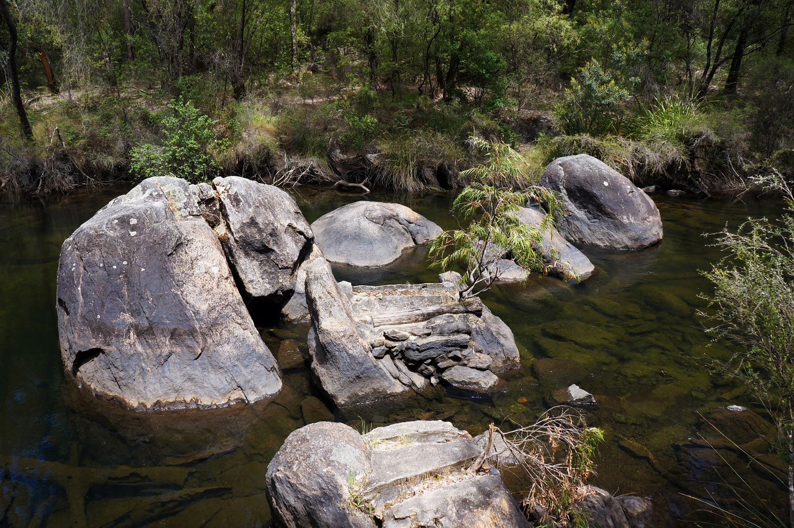
The area is filled with Granite formations, with the trail itself often passing over large Granite slabs. Like Sullivan Rock and the sections over the Monadnocks, rock cairns help guide the way over these sections.

Although initially staying fairly close to the river, the trail rises up inland not long after crossing a large Granite slab. The ascent here is fairly moderate however, and although this is the 'hardest' part of the walk, I would not describe it as difficult or strenuous.

Being near the end of Spring, the moss on the granite boulders had already begun to brown and die away, however it was interesting to see moss sporophytes preparing for the dry Summer and for the moss to regrow next year.

After staying relatively high above the river for a small stretch, the track again descends to be right along the Collie River.

Across the river are a number of lookouts and river access points. A scenic drive runs on the other side to Honeymoon Pool, and I would later discover that Alissa got to see some of the same views I did while following the scenic drive to meet me.

Although rocky, much of the Collie River is fairly tranquil however there are a number of beautiful rapids that can be seen from the track.

With the very last minute change of plans, I had not thought to bring my Neutral Density filters and tripod with me to take some long exposure photos, and I was kicking myself given how beautiful the rapids were. I was instantly reminded of the rapids seen along the Tom Road to Boarding House stretch of the Bibbulmun Track as well as those in Walyunga National Park though I would think the latter is running fairly dry at this time of year.

At other moments, the tranquil sections of the river reminded me more of other walks like the Luke Pen Walk in Albany, however due to the lack of nearby development the river views here were wilder - ironic considering there is a dam upstream!

As I continued along the river, I noticed an old wooden post near the track. This is one of the old Bibbulmun Track Stage Markers, indicating that this is the sixth reference point along Stage 16. This reference point used to mark where the the trail would form a loop known as the Sika Circuit. The Sika Circuit no longer connects to the old Bibbulmun at this location as it has been modified, however the trail still exists as a dual use trail more commonly used as a cycle trail.

Immediately after the Stage Marker, the Jabitj Trail reaches what used to be the intersection with the Sika Circuit, however the old Sika Circuit section is now used by the Munda Biddi and the Kurliny Tjenagitj Trail.

The next section of the trail is shared by the Munda Biddi and Kurliny Tjenagitj. In spite of the track being mainly used by cyclists, it is still nice and narrow track, with lush forest on either side.


Walkers will again encounter a junction in the trail, with the Kurliny Tjenagitj branches off again and goes back uphill. The Kurliny Tjenagitj Trail is very steep compared to the Jabitj Trail, and I initially thought I would follow the trail uphill to a lookout that is a few kilometres into the walk. After 40 minutes of walking up steep switchbacks, I decided that the Kurliny Tjenagitj Trail was a substantial enough walk to get its own coverage another time, and I decided to keep my focus on completing the Jabitj Trail instead. Stay tuned for a Kurliny Tjenagitj post sometime next year!

Shaded by tall trees, the next stretch of the Jabitj Trail was very pleasant and features some interesting Granite formations alongside the track. I can see why they brought this section back as a stretch of the Munda Biddi - the only thing I don't get is why it wasn't kept for the Bibbulmun!

After another section relatively high above the river, the Jabitj descends to a series of rapids.
Although I had seen a few of these by now, the rest were either a short distance away from the track or could only be reached by walking down an ad hoc spur to the water's edge. These rapids were immediately accessible from the trail itself and I was able to walk across several rocks to be standing right in the middle of the flowing waters.


Nearby, there were cleared areas that looked like there had once been tent sites in this location, and this seemed to be confirmed by the appearance of a fairly impressive toilet, with steps that looked an awful lot like the steps at Tom Road campsite on the Bibbulmun. My guess is that these are the remnants of The Ferns campsite that was closed after the Bibbulmun realignment meant it no longer served a purpose.

Shortly after passing The Ferns, the Jabitj Trail crosses over (or if you prefer, under) a bridge before continuing on along the river. At this point, the Munda Biddi crosses the river and continues on the other side.

From here, the Jabitj Trail follows a series of boardwalks along the Collie River as it heads towards Honeymoon Pool.

Again, this is an impressive amount of infrastructure for a poorly promoted trail, however it makes some sense given the popularity of the nearby Honeymoon Pool.
There are a number of excellent lookouts along the boardwalks, with Granite formations all along the river. The ones picture above shows clear signs of having once been modified to be a bridge across the river, however the bridge has since been removed.

Getting closer to Honeymoon, Pool, there was a noticeable change in the character of the river, with even greater lushness than what I had encountered earlier along the walk. With the lookouts and boardwalk, the river now reminded me of the riverside stretch of the Warren River Loop near Pemberton. Its amazing how much this river's character can change over a mere 6 kilometres!

Given how beautiful the Honeymoon Pool area is, it was no surprise to see many groups camping within the campgrounds. As a hiker with a tiny lightweight tent that is only just big enough for Alissa and I, I am always interested to see the vastly different approach of car-based campers who live in veritable mansions by comparison! With mildly warm Spring weather,Honeymoon Pool was just about at capacity, with many large family groups enjoying a camping weekend away.


This is a truly beautiful spot for a campsite, and I can see why Honeymoon Pool is consistently listed as one of the top 5 camping spots in Western Australia.

Finally, I reached the end of the Jabitj Trail near a lookout and river access point right in the middle of the Honeymoon Pool precinct. This definitely bore a strong resemblance to the Warren River Loop, and I could see many families getting ready to launch kayaks into the Collie River's tranquil waters.

No one ever talks about Collie as being the favourite section of the Bibbulmun Track (in fact, its normally quite the opposite), and as such I had very low expectations for walk trails in the Wellington National Park area. Needless to say, I was pleasantly surprised by the national park and the Jabitj Trail in particular, as it was an impressively beautiful walk that somehow seemed like a highlights reel of just about every other river walk I've done in the South West in spite of being a relatively brief 6 kilometres. I am extremely curious as to why this section of the Bibbulmun Track was not kept when the track was realigned in 1998, as this was a more impressive stretch of track that many sections that are part of the current alignment. Whatever the case, I am very thankful that it continues to live on as the Jabitj Trail and would definitely recommend it to anyone visiting Wellington National Park.


Looks wonderful, we stopped by over the Easter weekend however were deterred by the camping crowds. Hope to camp in the off season and do a trail or two.
ReplyDeleteIts a really beautiful area. I'm not surprised that it gets crazy busy over long weekends. Probably best to go down on a mild Winter weekend to avoid the peak crowds in Spring and Autumn!
Delete