
One of the most challenging and spectacular coastal walks in the South West, the Bald Head Walk Trail traverses the hilly Flinders Peninsula in Torndirrup National Park, taking walkers along the high coastal ridge to its easternmost point at Bald Head. This tough walk features beautiful granite rock formations alongside expansive views of the roaring Southern Ocean and tranquil King George Sound. A must do for experienced bushwalkers.
Distance: 16 km (return)*
Gradient: Hilly, with some very steep ascents and descents that require scrambling
Quality of Path: Highly variable, ranging from duck boards to concrete steps to washed away sandy ridges with 'steps' over a metre tall. Trail can be slightly overgrown at points but is relatively easy to discern for the most part.
Quality of Signage: Very little signage. Some areas feature wooden pegs as markers, and cairns are used over the large granite domes. The path was less clearly marked on the return walk but easy enough to find the few times we went the wrong way.
Experience Required: Previous Bushwalking Experience Required. This walk features some tough sections in a remote peninsula with no vehicle access, and would not be suitable for beginners.
Time: 4-5 Hours
Steps: Many significant steps, especially on the sandy hills. The sandy steps leading to Bald Head were washed away and required climbing up and down steps that were over a metre tall.
Best Time to Visit: All year round, though best to avoid in stormy or very hot weather
Entry Fee: No
Entry Fee: No
Getting There: Access to Torndirrup National Park is via Frenchman Bay Rd. Continue down the road past the popular tourist attractions on The Gap Rd and Blowholes Rd and turn right onto Salmon Holes Rd a few streets further down. Turn left onto Murray Rd then take the first right to the Bald Head Trail car park. Trailhead is clearly signed.
*There is some conflicting information regarding this track's length, with some sites saying it is only 12 kilometres long, and one source even going so far as to say it is only 10 kilometres! I am erring on the side of caution and suggest it is better to be prepared for 16 kilometres rather than a shorter distance.
*There is some conflicting information regarding this track's length, with some sites saying it is only 12 kilometres long, and one source even going so far as to say it is only 10 kilometres! I am erring on the side of caution and suggest it is better to be prepared for 16 kilometres rather than a shorter distance.

Although I've done much research on walks in the South West, the Bald Head Walk Trail in Torndirrup National Park is one that I only heard about fairly recently, with the trail added to the TrailsWA website, and having been written up on the Life of Py. It didn't appear in the DEC publication Bushwalks in the South-West, never featured on the old Top Trails website and seems altogether little known (or at least discussed). When hearing that the walk traversed the Flinders Peninsula of King George Sound right to its furthest point, it sounded like an incredible walk, and one that we absolutely had to check out during an impromptu weekend in the Great Southern.

The track starts surrounded by Peppermint Trees and other coastal species, and initially follows purpose built duck boards. The duck boards are of variable condition; some sections are very good while in others the wood has largely disintegrated, and on the return walk an uphill section of broken boards proved to be the most arduous part of the walk.

Even early on, the views are remarkable. On the day we walked the track, storms had been forecast, however we were gifted with clear sunny skies the whole time. This was a mixed blessing - the blues of the ocean and the sky were outstanding, however it also meant a seriously hot walk with little cover. 29°c may not seem so hot, but in totally open terrain with no cloud cover it left us very sweaty and - more seriously - sunburnt. The heat definitely gave us an indication of why Torndirrup National Park had recently suffered a bushfire nearby, as evidenced by the blackened foliage in the background of the above photo. Thankfully, the fire stopped before reaching the area that the Bald Head Trail passes through.
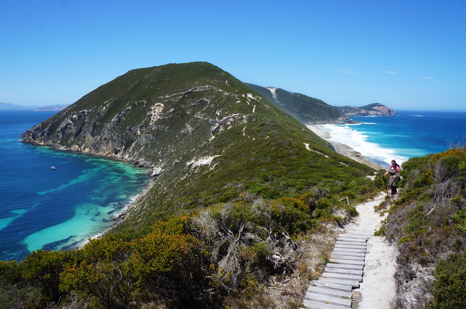
Ascending and then descending the first of the track's hills, the entirety of the peninsula comes into view. It is a stunning and imposing sight. A boat to the left side of the above picture give some suggestion of how large immense the peninsula is, but the furthest point appears a lot closer than it actually is.

An interesting feature of the walk is being privy to two very different views of the surrounding waters. Heading to Bald Head, the right side of the peninsula features the wild Southern Ocean, with frequently churning waves crashing into granite headlands and beaches of solid rock.

Meanwhile, the view to the left of the track could not be any more different, with the calm waters of King George Sound showing off why this is one of the country's best natural harbours. Protected by the peninsula, the beaches on this side are generally sheltered from wild conditions. On the hot day we were walking, the cooling winds from the south were at times our only respite, with the windless sections closer to the King George Sound side being particularly taxing.

The duck boards eventually disappear, with the rest of the track following a relatively well trodden sand trail. Given the soft sandy conditions, the track is fairly susceptible to erosion, and as a result an uphill section of the track has been given a set of concrete steps to assist walkers in the climb.


As the track climbs, it provides even more impressive views of King George Sound. The Vancouver Peninsula that separates Princess Royal Harbour can be clearly seen, as well as the many islands of the Sound (Seal Island is pictured above).

It is interesting to see how the Flinders Peninsula alternates between granite and limestone rock formations, with the ascent up Isthmus Hill dominated by limestone.

After largely focusing on the Sound to the north, walkers reaching the top of Isthmus Hill are rewarded with views of the walk's destination at Bald Head.


Given the predominance of low coastal heathland, sections of shade provided by Peppermint Trees will be welcome relief - especially if the track is walked in the hot conditions we had encountered.

After Isthmus Hill, the track reenters sections where granite predominates.

However, this section is short lived, and it enters an area of soft sand and small limestone cliffs.

Most of the time the break from limestone to granite is abrupt, but an area beyond the small limestone cliffs seems to be an area of transition. The dullness of the granite surfaces and the appearance of limestone soils suggests this is an area that was once covered in limestone that has only relatively recently been washed away (geologically speaking).

Heading further along, walkers will encounter a large granite ridge covered in orange-red speckles similar to the Remarkable Rocks in Adelaide and formations along the Meelup Trail. Even in Summer, an ephemeral Gnamma was filled with water, and we thought this to be one of the prettiest spots along the track.

The colouring of the rocks were just amazing, having an appearance not dissimilar to Abstract Expressionism or Aboriginal Art.

As we marvelled at the speckled rocks, Alissa and I thought we must be close to the end. As we reached the end of the ridge and looked down, we realised that Bald Head was still some distance away - and down a fairly steep descent.

This section was one of the most challenging along the track (and even worse on return), with rains having washed large sections of it away to the point where walkers are required to climb down 'steps' that are over a metre tall. It adds a sense of intrepidness to the track, however walkers not comfortable with a bit of scrambling should take this into consideration before heading out this far.

Exposed to the tumultuous Southern Ocean, it is impressive to see life still so abundant at the far reaches of the Peninsula. Even in February, several heathland plants were in bloom, creating a lovely patchwork of colour.


Although admittedly less spectacular than the Gap and Natural Bridge, the track provides similar views of waves crashing into the granite cliffs on either side of the peninsula. Being a wilder experience than the Gap's tourist friendly boardwalks and lookout does impart a great sense of adventure to the walk, and in wet weather I can imagine some of the slippery granite surfaces being particularly treacherous if one were not careful and considered in their walking.


The trail's end is marked clearly by a giant cairn located on Bald Head. This is the easternmost point of the Peninsula, and would be one of the few places in WA from which to watch the sun rise from the ocean. During Whale season, this is apparently an excellent vantage point to watch their migration and would be reason alone for Alissa and I to walk this trail again.

Alissa and I stopped for a snack as we sat on Bald Head. As a final gift, walkers can view a small low lying granite island just below Bald Head as the waves continually crash into it. This can be quite hypnotic - alternating between an explosive crash of water and followed by water flowing back into the sea like a temporary waterfall of sorts. From there, it was a matter of simply returning the way we came. Due to the wash outs and disintegrated duck boards, this is not the easiest of return walks, but was made very difficult due to the midday heat. By the time we got back to our car, both Alissa and I were pretty broken, with Alissa referring to it as a being a literal blood, sweat and tears track - and the hardest walk she had undertaken to date.
In spite of the difficulty, Alissa and I were absolutely blown away by this walk. Having walked all of the Bibbulmun's coastal sections from Walpole to Albany, I would consider the Bald Head Walk Trail even more spectacular, and in its own way it would be right up there with the Grand Canyon Walk in the Blue Mountains as one of the finest day walks Alissa and I have had the privilege of trekking. The fact it is not one of the state's Top Trails or listed as one of Australia's best day walks anywhere online seems more to do with its relative obscurity than its actual quality - it is certainly a more impressive trail than many of the supposed Top Trails in the Perth area for instance.
The fact that DPaW do not seem willing to really promote this trail is a real shame then, but I do understand their hesitation. It is not an easy walk, and being located in an area without any road access almost certainly means calling in emergency services if something goes wrong. As such, I would actively discourage anyone who has little to no bushwalking experience undertaking this trail, and although Alissa and I walked it in hot weather, this would definitely not be advisable. But for experienced walkers seeking a challenge, the Bald Head Walk Trail is an utterly rewarding walk and one of the state's best. If you're fit and experienced enough, the Bald Head Walk Trail is a must do, and I cannot recommend it enough.


We have walked it many times. We love it. It is one of Albany's best kept secrets.
ReplyDeleteFantastic,really enjoyed reading this and the great photos to showcase it. We are driving to Albany this weekend and now very inspired to tackle this walk.
ReplyDelete