

One of the most incredible mountain summit hikes in Australia, the trek up Mt Amos is a tough and challenging scramble in Freycinet National Park. Following an incredibly steep ascent up occasionally slippery Granite slopes, the difficulty of the trail is amply rewarded by the incredible and classic bird's eye view of Wineglass Bay and the Freycinet Peninsula. A must do for experienced hikers comfortable with scrambling
Distance: 4 km (return)
Gradient: A continual ascent and the descent, with generally steep gradients that regularly require scrambling
Quality of Path: Clear and well defined trail, with sections on uneven, rocky and unmodified terrain. Includes a lengthy section of scrambling up a slippery granite slab with only a fissure in the rock for footing
Quality of Signage: Generally well signed and clear, with a good trailhead and clear directional arrows along the way
Experience Required: Bushwalking Experience Required
Time: 3-5 Hours
Steps: Many
Best Time to Visit: Anytime of year, so long as the rock is not wet. This walk would be very dangerous in wet weather.
Best Time to Visit: Anytime of year, so long as the rock is not wet. This walk would be very dangerous in wet weather.
Entry Fee: Yes. National Park Fees apply.
Getting There: The trail starts at the main Wineglass Bay car park. Take Coles Bay Rd into peninsula where it becomes Freycinet Dr. Follow Freycinet Dr to the well signposted car park. The trailhead is located on the eastern side. 
"No no no... if you want that classic view of Wineglass Bay, you've gotta climb Mt Amos"
Such was the advice that was offered separately to Alissa and I by our bartender at IXL Bar and the shop assistant at Mountain Creek Outdoors when we told them we were going to do the Wineglass Bay and Hazards Beach Circuit in Freycinet National Park. Based on the Tasmanian Parks and Wildlife Service's Great Short Walks, the Wineglass Bay and Hazards Beach Circuit looks to be the park's best day walk as it is basically a shorter version of the popular multi-day Freycinet Circuit, however reading about the amazing views and exciting scrambling up Mt Amos it became clear that this was the walk we needed to do.
Driving from the Tasman Peninsula to Freycinet, Alissa and I popped into a few of the region's well regarded wineries, with Devil's Corner having an incredible lookout across Coles Bay towards the Freycinet Peninsula (pictured above). From this distance, the mountains did not look particularly massive, and the 445 metre height of Mt Amos does not sound that impressive when you consider we'd reached the summit of the 1458 metre above sea level Mt Jerusalem a week earlier. The being said, when you drive into the park at what is basically sea level, Mt Amos and the other peaks of the Hazards Range look absolutely imposing as while they may not reach the heady heights of the mountains of the Walls of Jerusalem, they are far more geographically prominent. Where the Mount Jerusalem Track starts at around 1200 metres above sea level at Dixons Kingdom, the Freycinet National Park car park is not far off from sea level. The result is a mountain that looks almost twice as imposing at the trailhead than Mt Jerusalem did from Dixons Kingdom. When you consider that Mount Freycinet is even taller at 620 metres, you know that these are seriously tall mountains from base to summit by Australian standards!

The Mt Amos Track starts a short distance down from the main trailhead. Signage warns hikers that this is a fairly serious undertaking due to the steep and potentially slippery granite slopes, and walkers are required to sign in for Mt Amos or any overnight hikes due to safety. Parks and Wildlife have done a good job with this as it is imperative that casual tourists are kept away from a walk like this; none of us want injuries to happen due to inexperienced hikers undertaking something beyond their skill level, and experienced hikers don't wants tracks closed due to departments becoming too risk averse and removing the adventure and fun for those who have the ability to undertake a walk like this.

From the trailhead, the track initially passes through a low swampy area along a boardwalk, because this is Tasmania after all! This does not last long however as the track swings around on a switchback as it heads up the mountain. While continuously uphill, the initial gradient is fairly moderate as it makes it way up through the scrub and mallee.

Once up through the scrub, the track reaches the first section of sustained, exposed granite. From this point Alissa and I were privy to excellent views of Coles Bay.

From here, the walking becomes an almost continuous walk along granite that varies in texture from coarse and grippy to dangerously smooth and slippery. Its quite obvious why this walk is not recommended in wet weather as it would be very easy to slip even at this early and relatively tame stage of the walk.

While the terrain is relatively wild, yellow markers on the rocks make the track fairly easy to navigate. For the most part, the way to go is obvious as its regularly the only sensible way to traverse the granite slopes.

As we made our way up, the views of the nearby mountains became more and more dramatic. The overall appearance split the difference between the beautiful granite domes of the Porongurup Range and the small peaks of Monadnocks Conservation Park near Perth in Western Australia. As a fan of both areas (particularly the Nancy Peak Circuit and the traverse of the ridge on Mt Cooke), I was in mountain walking heaven.

The track swings right as it reaches a large granite boulder. When I asked Alissa to stand next to the rock to illustrate its scale, Alissa decided to stand dejectedly to illustrate her dislike for the continuous ascending we'd been doing. Thankfully, the next section would be relatively even as we walked across the mountain to the next uphill slope.

While even, this section was not without its difficulties. The granite along this stretch had been polished smooth by centuries of water flowing down the mountain, with a small flat section along a fissure being the only reasonably safe space for secure footing.

The track then swings left as it heads right up the mountain. At this point the gradient greatly increased in steepness, and with limited hand and foot holds we had to pay careful attention to the directional arrows to identify the easiest and safest way to make our way up.
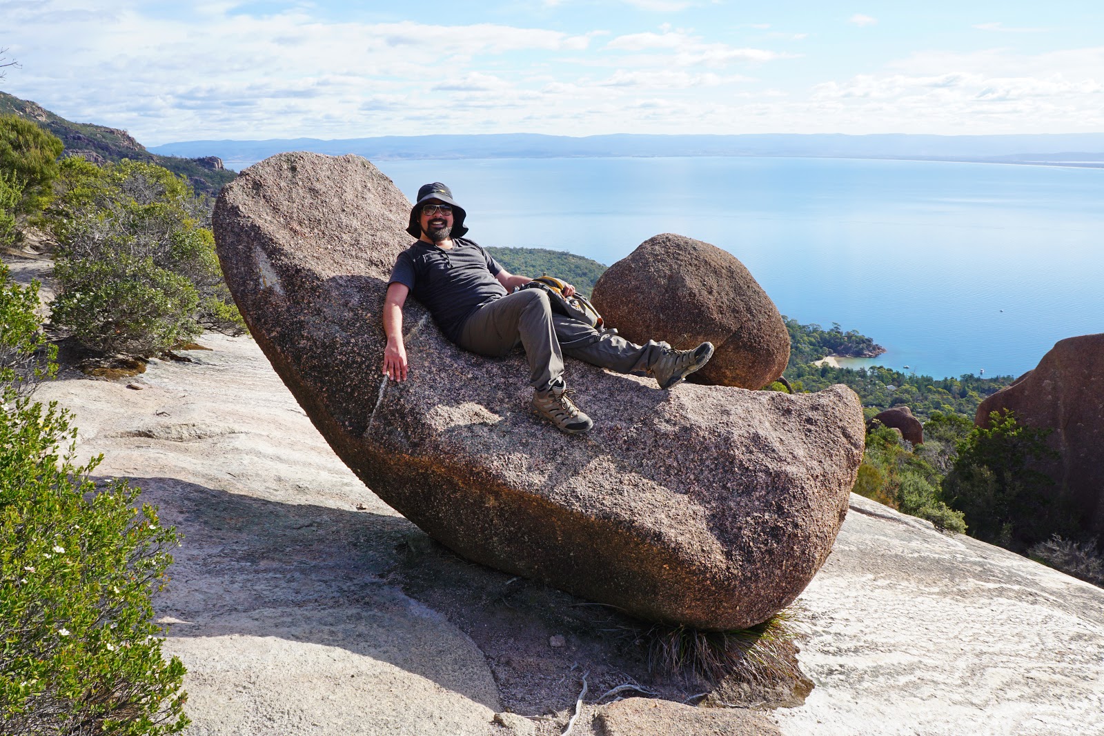
Along another flat section, a curved rock looked like a semi-comfortable rock recliner and I had to test it out. While actually hard and uncomfortable, this was a fun rest stop and one that reminded me a lot of the rock couch at Helena Campsite on the Bibbulmun Track.


After scrambling our way up steep and challenging climbs, Alissa and I reached a section that was particularly slippery as we walked across the rock to continue the ascent to the right. It was at this point that we reached the crux of the walk as the scrambling became steep and challenging as we had to make our way up a section with only a fissure in the rock for hand and foot holds.

This was definitely on the upper end of difficulty for Alissa, and she was so scared of a potential fall that she wanted to call it quits. I waited patiently for her until she gathered her courage and reasoned with her that she had already made it most of the way up to the summit and that the pay off was just around the corner. Seeing that I was staying with her and was not going to continue on without, her Alissa pushed through and did quite well negotiating the tough terrain.

Alissa and I were then relieved to be standing upright and hands free in a vegetated bowl just below the summit. The track follows the left side of the bowl as it skirts the granite rock before heading through the vegetation to the right.

An arrow painted onto the rock points up a rock ramp. At this point it was not clear how far we were from the top, but this arrow is basically the home stretch to Mt Amos' incredible summit views.


After all the tough scrambling, Alissa and I were literally stopped in our tracks by the spectacular view that greeted us. Being from Western Australia, Alissa and I have grown up spoiled by having access to some of the most beautiful beaches anywhere in the world, and have been disappointed by hyped-up beaches in other places we have visited. With its perfect crescent shape, white sands and piercingly blue waters, Wineglass Bay was as jaw-droppingly gorgeous as the tourism brochures say. With the mountain peaks behind it, it reminded me of Fitzgerald Beach and the Mid Mount Barren in Fitzgerald River National Park back home in Perth, however the high viewpoint from Mt Amos made it even more stunning. The view was so good that Alissa and I spent about 45 minutes up there taking it all in - after all that effort, we were definitely going to get our climbing's worth!

Looking to the west, Alissa and I could see Mt Mayson. The saddle between the two mountains is where the Freycinet Circuit and the Wineglass Bay and Hazards Beach Circuit pass through, and also features its own lookout point. Having seen photos from the lower lookout, it is pretty clear the Mt Amos is a vastly superior vantage point, and Alissa and I were definitely fortunate to be fit and able enough to experience the views from the summit for this reason.

After enjoying the summit, Alissa and I made our way back down the mountain.

At times, lowering ourselves down the granite was more challenging than making our way up given that we were now facing forward and seeing just how steep the gradient is. While I did my best to carefully lower myself down the rocks, Alissa attempted her trademarked descending tactic of sliding down the rocks. I'm not a fan of this tactic as its been a costly one one for us in the past, and I was not surprised at all when it yielded predictably pants-tearing results. Luckily she wasn't wearing her expensive North Face pants!

In spite of the torn pants and a scratched up butt cheek, Alissa seemed to be in particularly high spirits on the way down. What follows is a series the overly cheery highlights.


While being a challenging mountain walk, Mt Amos definitely lived up to our expectations, and Alissa and I were very glad that we had listened to others' advice and changed our plans for Freycinet National Park. Alissa and I have had the great fortune of having completed a number of great mountain walks in Australia, including Mt Ossa from the Overland Track, the peaks of the Walls of Jerusalem Circuit and the Main Range Track in Koskiuszko National Park. While Mt Amos is decidedly shorter in stature, it would be right up there as having one of the most breathtaking summit views we've ever experienced given that it looks down onto the coastal scenery of the justly celebrated Wineglass Bay and Freycinet Peninsula. Being relatively difficult and one that should not be done in wet weather, Mt Amos will not be for everyone but those with experience and scrambling ability with find a lot to love about this outstanding walk and national park. After completing Mt Amos, Alissa and I agreed that the area was so beautiful that this would not be our last visit to Freycinet - we will be back again in the future to tackle the Freycinet Circuit.


0 comments:
Post a Comment