

One of the best day walks in the Perth area, the Cooke Plantation trail to Mt Cooke provides the best access point for reaching the summit of the Darling Scarp's tallest peak. Following an unmarked but surprisingly well maintain trail from the Cooke Plantation, the walk rises up the granite slope before joining the Bibbulmun Track to the summit. Featuring a cave, rugged ridge walking and spectacular views, this is a must do.
Distance: 7.5 km (one way)
Gradient: Largely a gradual uphill walk with some gentle sections across the ridge to the summit.
Quality of Path: Generally clear and well maintained. Mt Cooke is largely made of granite - extra care must be taken in wet and slippery conditions.
Quality of Signage: Well signed along the section shared with the Bibbulmun Track, with the Waugal providing very clear directional information and some cairns across Mt. Cooke. No markers along the trail leading to the Bibbulmun Track from Cooke Pine Plantation.
Experience Required: Bushwalking Experience Required. Though not overly tall, Mt. Cooke is still the highest peak of the Darling Scarp, and does have some tricky ascents and descents that would be a problem for those with known knee problems.
Time: 2 Hours
Steps: Some steps in places, but mostly natural slopes
Best Time to Visit: Late Winter/Early Spring
Entry Fee: No
Entry Fee: No
Getting There: The trail starts at a car park located behind the Cooke Pine Plantation. Following the road along the plantation boundary, the car park is located in the southern half of the plantation and is an prominent turning circle just to the east of the boundary line. See map below.
If you've done a reasonable amount of hiking in Western Australia, you'll probably be familiar with Mt Cooke in Monadnocks Conservation Park. Located off Albany Hwy, Mt Cooke is notable for being the highest peak in the Darling Scarp at 582 metres, and for being one of the most iconic highlights of the Kalamunda to Dwellingup stretch of the Bibbulmun Track. Traditionally, Mt Cooke is accessed from the Sullivan Rock day use area on Albany Hwy (marked in yellow in the map above) with walkers then following the Bibbulmun Track via Mt Cooke campsite to the summit. For those doing a sectional End to End, it is possible to park a second car at Powerline Rd (marked in red), thus allowing you to traverse Mt Cooke in its entirety. This is how we did Mt Cooke the first time - you can read about it here.
Since then, we'd visited Mt Cooke two more times. For our second visit, we walked from Sullivan Rock to the summit and across the ridge and back. While enjoyable, I didn't find this 100% satisfying as the best bits of Mt Cooke are south of the summit across the ridge, and the vast majority of the walk from Sullivan Rock is spent getting to Mt Cooke through scrappy Jarrah rather than focusing on the mountain itself. For our third visit, we walked in from Powerline Rd to the summit. This was a better experience - there is less time spent walking to Mt Cooke, and the walk to the summit incorporates the best bits of the ridge walk to the summit including the famous boulder cave.
While coming back down Mt Cooke, we saw a distinct but unmarked trail running off towards the Cooke Plantation and decided to investigate. What we discovered was a surprisingly well maintained trail that allowed fairly direct access to Mt Cooke - complete with it own car park (marked in green)! Excited by this discovery, we agreed to come back to document this walk over the Winter months, finally getting around to exploring the route in early August.

The walk starts from a car park located on the other side of the Cooke Plantation on Albany Hwy, and features a prominent car park with a large turning circle - see the map above for its exact location. Some of the roads within the plantation are not suitable for two wheel drives and they occasionally close roads if harvesting is taking place, so you may need to instead park on Albany Hwy and walk in from there. From the car park, two vehicle tracks head east towards the mountain - one just to the left of the car park and one straight ahead. Take the one straight ahead. Please note however that these roads are within the Disease Risk Area and you should not drive your vehicle any further than the car park due to the risk of spreading Dieback in Monadnocks Conservation Park.

Disappointingly, there is clear signs that people are driving down these forestry roads and - more worryingly - are creating fire rings in the Conservation Park. Considering the proximity of the fire to the pine plantation and its location within an important conservation reserve, this kind of activity should not be happening - please respect 'Leave No Trace' principles and rules regarding lighting fires while in protected areas.

Less than 500 metres into the walk, the trail becomes impassable for vehicles and follows a single file walking track that runs alongside a creek.

Shortly after first reaching the creek, the track crosses over to the other side. There are no markers as this is not an officially managed track, however the trail is surprisingly clear and easy to follow. If in doubt, simply following the stream should get you back to a clear path.

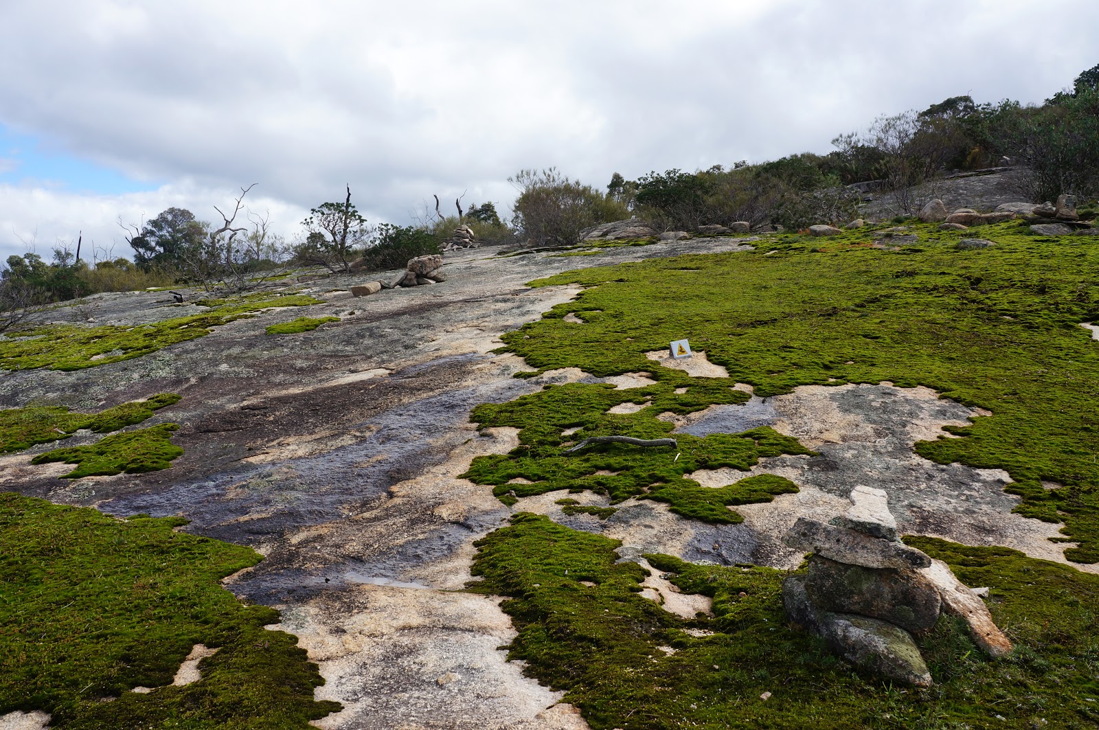
Crossing back over to the other side of the creek once again, the trail reaches a large granite expanse surrounded by many large boulders.


The trail continues up the large granite expanse, with a series of cairns marking the route across the rock - it is really remarkable how well set up this little known route is! As with all granite outcrops, please try to avoid walking on the moss - there are more than enough clear areas for this to be easy enough to do.

The creek runs along the rocks, with the trail running just to the right. Not long after leaving the large granite expanse, the trail crosses over the creek one last time before ascending through the scratchy scrub. Even though the trail is not overly manicured, the path is nevertheless relatively clear - I've walked sections of the Bibbulmun Track that are more overgrown that this trail, which leads me to think that someone is secretly maintaining this walk.

Out of the forest and scrub, the track provides spectacular views across the Jarrah forest to the south of Mt Cooke. Within the forest is a massive granite outcrop of angular boulders. This is something I'd be very interested in exploring another time, as I can imagine the outcrop offering some fun bouldering opportunities.

Continuing along the trail, a series of cairns suggest heading up the somewhat slippery granite slope as it leads to Mt Cooke. Following the cairns, Alissa and I found this route to be easy enough to follow, however the slipperiness of the rock makes this route potentially dangerous during the wetter months. At various times, Alissa and I came close to slipping, and it was only by taking a slow and steady approach that we made it up without incident. On the way back, we discovered that if we had ignored the cairns and continued straight a bit further beyond, there is a somewhat safer way of heading up the granite slope. As always - use your own judgement and if in doubt err on the side of caution.

Continuing up the granite slope, the trail meets up with the Bibbulmun Track. From here until the summit, the trail is very easy to follow as it is follows the Bibbulmun's distinctive Waugal markers.

Once clear of the large granite slope, walkers will be in the area of Mt Cooke's famous Boulder Cave. I'd searched for the cave multiple times but had always looked for it in the wrong place. Our friend Mark from the Life of Py helped point us in the right direction, and we were able to find it during our third visit. Heading north, the cave is to the right of the track right underneath a massive and highly prominent boulder. Its fairly obvious once you know what you are looking for.
Don't expect a large, cavernous space along the lines of the limestone caves of Leeuwin-Naturaliste National Park; Mt Cooke's Boulder Cave is not tall enough to stand up in, however its weathered granite surfaces provide a lot of interest. The Bibbulmun Track guidebook suggests that the cave has 'provided shelter for many a walker in the past', and it would be large enough for a small group to have a picnic inside (take your rubbish with you!). For those who are so inclined, you can leave comments in a log book inside.

From the cave, the Bibbulmun continues up across the ridge. To the left of the track is an excellent viewpoint, providing stunning vistas of the landscape to the west.

If you've never walked Mt Cooke before, it should become immediately apparent why it is one of Perth's most beloved hiking locations - the rugged walking across the ridge is spectacular. Before hiking Mt Cooke, I had no idea that such incredible granite peaks could be found anywhere near Perth. The fact that you get to traverse quite a few of them between Kalamunda and Dwellingup on the Bibbulmun makes it one of my favourite town to town stretches of the Track.

Although not exceptionally steep, the ridge is fairly up and down as it passes through a continuous jumble of granite boulders and outcrops along the way.


Not far from the summit is an unusually flat clearing that is semi-regularly used as an unofficial camping spot. While I definitely see the appeal of camping here given the spectacular 'top of the world' views, Alissa and I once walked past this spot and were disappointed to find that fire rings had been constructed by campers with garbage just dumped in gaps between the rock. If you're wild camping, please keep in mind that this is a fuel stove only area and have the courtesy to take your rubbish with you.

Continuing along into a forested area, the track runs along a narrow, curved granite slab. I always consider this granite slab to be something of a landmark as the summit is only a short distance further down the track from here.

Surrounded by trees and a few large boulders, the summit of Mt Cooke is a bit anticlimactic as it does not provide much in the way of 360° views - in this regard the nearby Mt Cuthbert offers a superior summit experience. My intention with this walk was to go to the summit and back, however walkers looking to stay overnight could continue on along the Bibbulmun Track to Mt Cooke campsite - the campsite is only 2.5 kilometres further down the trail.

Walking back along the ridge, I spotted one of my favourite landmarks along the ridge - a granite rock that looks like it has a mouth. For some reason I've always though the rock looked like Domo (the mascot for the Japanese public broadcaster NHK) however a direct comparison reveals that they actually look quite different.
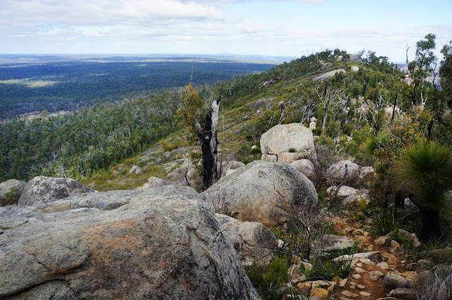
The ridge provides such fantastic walking that this is one of those return walks that is not simply a repeat of the same scenery. In the distance, walker can catch glimpses of Boonerrring Hill and the White Horse Hills - some of my other favourite granite-dominated sections of the Bibbulmun Track.

Reaching the granite slope that makes its way down Mt Cooke, walkers will need to keep following the Bibbulmun Track until it reaches a point that takes a sharp left turn. At this point, walkers will return to the unmarked trail that runs to the Cooke Pine Plantation. Making our way back down, Alissa and I took a safer alternate route down the slope - this alternate route involves a sharper turn to the right rather than continuing straight down the slope, and meets up with the obvious trail before it descends back into the forested part of the walk.

If you've done a reasonable amount of hiking in Western Australia, you'll probably be familiar with Mt Cooke in Monadnocks Conservation Park. Located off Albany Hwy, Mt Cooke is notable for being the highest peak in the Darling Scarp at 582 metres, and for being one of the most iconic highlights of the Kalamunda to Dwellingup stretch of the Bibbulmun Track. Traditionally, Mt Cooke is accessed from the Sullivan Rock day use area on Albany Hwy (marked in yellow in the map above) with walkers then following the Bibbulmun Track via Mt Cooke campsite to the summit. For those doing a sectional End to End, it is possible to park a second car at Powerline Rd (marked in red), thus allowing you to traverse Mt Cooke in its entirety. This is how we did Mt Cooke the first time - you can read about it here.
Since then, we'd visited Mt Cooke two more times. For our second visit, we walked from Sullivan Rock to the summit and across the ridge and back. While enjoyable, I didn't find this 100% satisfying as the best bits of Mt Cooke are south of the summit across the ridge, and the vast majority of the walk from Sullivan Rock is spent getting to Mt Cooke through scrappy Jarrah rather than focusing on the mountain itself. For our third visit, we walked in from Powerline Rd to the summit. This was a better experience - there is less time spent walking to Mt Cooke, and the walk to the summit incorporates the best bits of the ridge walk to the summit including the famous boulder cave.
While coming back down Mt Cooke, we saw a distinct but unmarked trail running off towards the Cooke Plantation and decided to investigate. What we discovered was a surprisingly well maintained trail that allowed fairly direct access to Mt Cooke - complete with it own car park (marked in green)! Excited by this discovery, we agreed to come back to document this walk over the Winter months, finally getting around to exploring the route in early August.

The walk starts from a car park located on the other side of the Cooke Plantation on Albany Hwy, and features a prominent car park with a large turning circle - see the map above for its exact location. Some of the roads within the plantation are not suitable for two wheel drives and they occasionally close roads if harvesting is taking place, so you may need to instead park on Albany Hwy and walk in from there. From the car park, two vehicle tracks head east towards the mountain - one just to the left of the car park and one straight ahead. Take the one straight ahead. Please note however that these roads are within the Disease Risk Area and you should not drive your vehicle any further than the car park due to the risk of spreading Dieback in Monadnocks Conservation Park.

Disappointingly, there is clear signs that people are driving down these forestry roads and - more worryingly - are creating fire rings in the Conservation Park. Considering the proximity of the fire to the pine plantation and its location within an important conservation reserve, this kind of activity should not be happening - please respect 'Leave No Trace' principles and rules regarding lighting fires while in protected areas.

Less than 500 metres into the walk, the trail becomes impassable for vehicles and follows a single file walking track that runs alongside a creek.

Shortly after first reaching the creek, the track crosses over to the other side. There are no markers as this is not an officially managed track, however the trail is surprisingly clear and easy to follow. If in doubt, simply following the stream should get you back to a clear path.

Crossing back over to the other side of the creek once again, the trail reaches a large granite expanse surrounded by many large boulders.


The trail continues up the large granite expanse, with a series of cairns marking the route across the rock - it is really remarkable how well set up this little known route is! As with all granite outcrops, please try to avoid walking on the moss - there are more than enough clear areas for this to be easy enough to do.

The creek runs along the rocks, with the trail running just to the right. Not long after leaving the large granite expanse, the trail crosses over the creek one last time before ascending through the scratchy scrub. Even though the trail is not overly manicured, the path is nevertheless relatively clear - I've walked sections of the Bibbulmun Track that are more overgrown that this trail, which leads me to think that someone is secretly maintaining this walk.

Out of the forest and scrub, the track provides spectacular views across the Jarrah forest to the south of Mt Cooke. Within the forest is a massive granite outcrop of angular boulders. This is something I'd be very interested in exploring another time, as I can imagine the outcrop offering some fun bouldering opportunities.

Continuing along the trail, a series of cairns suggest heading up the somewhat slippery granite slope as it leads to Mt Cooke. Following the cairns, Alissa and I found this route to be easy enough to follow, however the slipperiness of the rock makes this route potentially dangerous during the wetter months. At various times, Alissa and I came close to slipping, and it was only by taking a slow and steady approach that we made it up without incident. On the way back, we discovered that if we had ignored the cairns and continued straight a bit further beyond, there is a somewhat safer way of heading up the granite slope. As always - use your own judgement and if in doubt err on the side of caution.
Continuing up the granite slope, the trail meets up with the Bibbulmun Track. From here until the summit, the trail is very easy to follow as it is follows the Bibbulmun's distinctive Waugal markers.

Once clear of the large granite slope, walkers will be in the area of Mt Cooke's famous Boulder Cave. I'd searched for the cave multiple times but had always looked for it in the wrong place. Our friend Mark from the Life of Py helped point us in the right direction, and we were able to find it during our third visit. Heading north, the cave is to the right of the track right underneath a massive and highly prominent boulder. Its fairly obvious once you know what you are looking for.
Boulder Cave on Mt Cooke - Spherical Image - RICOH THETA
Don't expect a large, cavernous space along the lines of the limestone caves of Leeuwin-Naturaliste National Park; Mt Cooke's Boulder Cave is not tall enough to stand up in, however its weathered granite surfaces provide a lot of interest. The Bibbulmun Track guidebook suggests that the cave has 'provided shelter for many a walker in the past', and it would be large enough for a small group to have a picnic inside (take your rubbish with you!). For those who are so inclined, you can leave comments in a log book inside.

From the cave, the Bibbulmun continues up across the ridge. To the left of the track is an excellent viewpoint, providing stunning vistas of the landscape to the west.

If you've never walked Mt Cooke before, it should become immediately apparent why it is one of Perth's most beloved hiking locations - the rugged walking across the ridge is spectacular. Before hiking Mt Cooke, I had no idea that such incredible granite peaks could be found anywhere near Perth. The fact that you get to traverse quite a few of them between Kalamunda and Dwellingup on the Bibbulmun makes it one of my favourite town to town stretches of the Track.

Although not exceptionally steep, the ridge is fairly up and down as it passes through a continuous jumble of granite boulders and outcrops along the way.


Not far from the summit is an unusually flat clearing that is semi-regularly used as an unofficial camping spot. While I definitely see the appeal of camping here given the spectacular 'top of the world' views, Alissa and I once walked past this spot and were disappointed to find that fire rings had been constructed by campers with garbage just dumped in gaps between the rock. If you're wild camping, please keep in mind that this is a fuel stove only area and have the courtesy to take your rubbish with you.

Continuing along into a forested area, the track runs along a narrow, curved granite slab. I always consider this granite slab to be something of a landmark as the summit is only a short distance further down the track from here.

Surrounded by trees and a few large boulders, the summit of Mt Cooke is a bit anticlimactic as it does not provide much in the way of 360° views - in this regard the nearby Mt Cuthbert offers a superior summit experience. My intention with this walk was to go to the summit and back, however walkers looking to stay overnight could continue on along the Bibbulmun Track to Mt Cooke campsite - the campsite is only 2.5 kilometres further down the trail.

Walking back along the ridge, I spotted one of my favourite landmarks along the ridge - a granite rock that looks like it has a mouth. For some reason I've always though the rock looked like Domo (the mascot for the Japanese public broadcaster NHK) however a direct comparison reveals that they actually look quite different.

The ridge provides such fantastic walking that this is one of those return walks that is not simply a repeat of the same scenery. In the distance, walker can catch glimpses of Boonerrring Hill and the White Horse Hills - some of my other favourite granite-dominated sections of the Bibbulmun Track.

Reaching the granite slope that makes its way down Mt Cooke, walkers will need to keep following the Bibbulmun Track until it reaches a point that takes a sharp left turn. At this point, walkers will return to the unmarked trail that runs to the Cooke Pine Plantation. Making our way back down, Alissa and I took a safer alternate route down the slope - this alternate route involves a sharper turn to the right rather than continuing straight down the slope, and meets up with the obvious trail before it descends back into the forested part of the walk.

Once back down through the forested part of the walk, its an easy stroll alongside the stream encountered earlier as it leads back to the car park.
I've long considered Mt Cooke one of the best places for bushwalking in the Perth area; it may not be a true mountain like Bluff Knoll or Toolbrunup in the Stirling Ranges or Mt Bruce in the Hamersleys, but its about as good as it gets near Perth in terms of rugged terrain. While following the Bibbulmun Track from Sullivan Rock to Mt Cooke is a fantastic walk, this shorter version is even better, as it is basically all the hits (the ridge walking of Mt Cooke itself) without any of the filler (the long stretches through scrappy Jarrah forest). This would easily be one of my favourite walks in Perth - right up there with Kitty's Gorge and the Numbat Track as must dos.
I've long considered Mt Cooke one of the best places for bushwalking in the Perth area; it may not be a true mountain like Bluff Knoll or Toolbrunup in the Stirling Ranges or Mt Bruce in the Hamersleys, but its about as good as it gets near Perth in terms of rugged terrain. While following the Bibbulmun Track from Sullivan Rock to Mt Cooke is a fantastic walk, this shorter version is even better, as it is basically all the hits (the ridge walking of Mt Cooke itself) without any of the filler (the long stretches through scrappy Jarrah forest). This would easily be one of my favourite walks in Perth - right up there with Kitty's Gorge and the Numbat Track as must dos.


Greetings from Malaysia, is the mt cooke trail kids friendly? i'll be going to perth ath the end of this month. And what time recommended for summer hiking?
ReplyDeleteHi Dr Cat,
DeleteMt Cooke is a bit strenuous but I imagine adventurous kids who have experience with walking up a small mountain should have no problem with this walk. I've seen young families do the overnight hike in to the campsite near Mt Cooke and they've been able to manage it.
The summer is a bigger problem due to the fire danger. I would keep an eye out for the fire danger rating for the day and avoid it any day about 32 degrees, and even on those hot days I would try and get the walk in as early in the morning as you can as it can be unbearable out there in Summer.
Hope that helps!