

One of the finest and most exciting mountain walks in Western Australia, the Summit Trail leads hikers to the top of Mt Bruce - the second highest mountain in Western Australia. Initially traversing a series of hills, hikers scramble up the adjacent Chinaman's Hat before walking across a spectacular rocky ridge to Mt Bruce itself. With superb views from its summit, this is a must-do for peak baggers.
Distance: 9 km (return)
Gradient: Alternates between relatively easy, gentle gradients and sections of difficult terrain requiring scrambling
Quality of Path: Clear and well defined trail, with sections on uneven, rocky and unmodified terrain. Includes a section of semi-exposed scrambling
Quality of Signage: Generally well signed and clear
Experience Required: Bushwalking Experience Required
Time: 4-5 Hours
Steps: Many
Best Time to Visit: Winter
Best Time to Visit: Winter
Entry Fee: No. National Park Fees apply.
Getting There: The trail starts at the Mt Bruce car park. Mt Bruce Rd turns south off Karijini Dr almost immediately opposite the western turn off to Banjima Dr. 
From the way people talk about it, you'd be forgiven for thinking that Bluff Knoll was the tallest mountain in Western Australia, or that the Stirling Range is the only major range in the entire state. Its not even close - all of the 10 tallest mountains in Western Australia are located in the mighty Hamersley Range, with Mt Meharry holding the official title of the tallest peak in the state at 1249 metres. Tucked away in a rarely visited section of the park and requiring high clearance to reach it, Meharry is less regularly climbed than the second tallest mountain - the utterly Australian-sounding Mt Bruce. A lone and topographically prominent mountain, Mt Bruce is a major sight driving along Karijini Dr, standing 1234 metres above sea level. After having ticked four of Karijini's gorges off in our first two days in the park, Alissa and I woke up early to tackle the nine kilometre return trail to Mr Bruce's summit.

As well as being well located for access to Joffre, Knox, Hancock and Weano Gorges, the Karijini Eco Retreat was only a short drive away from the start of the Mt Bruce Trail, as Mt Bruce Rd is almost immediately opposite the western entrance to the park on Banjima Dr. Driving towards the peak, its pretty clear that the trail is taking a long but less steep route up the western side of the mountain, following a ridge of lesser hills and peaks before reaching Mt Bruce itself. The abundance of dead trees at the start of the trail indicated that a fire had been through the area in the recent past. Although the Spinifex had clearly recovered quite well, it will likely take many years for even small trees to reappear along the slopes.

500 metres into the walk is the Marandoo View - a viewpoint overlooking the nearby Marandoo Mine. I'm sure some will find this an exciting view, however I didn't think very much of the mine or the viewpoint. While I certainly understand the need for iron ore mining and its important role in the Australian economy, there's something a bit sad about these ancient mountains being cut down and shipped to China. Perhaps that's why they don't talk about the Hamersley Range as a great mountain range - in time, most of the peaks not protected by the national park will be completely flattened.

From the Marandoo View lookout, the trail traverses over a series of small rolling hills, with Mt Bruce looming ahead in the distance.

After skirting the edge of one of the smaller hills, Alissa and I were given a view of what we were up against, with some relatively easy walking across more low hills before reaching a steep peak just in from of Mt Bruce itself.

Even from these lower hills, the views are quite spectacular, with the mountains of the Hamersley Range stretching out in all directions.

Although we were yet to reach any truly steep sections, the trail does pass through a section of rectangular boulders that require some mild scrambling to get through. This rocky section doesn't last long before return to fairly straightforward walking along the clearly defined walk track.

2.3 kilometres into the walk, the trail reaches another vantage point surrounded by Honey Hakea. Having been recently burnt, the trees were not particularly impressive looking, however the view of the Marandoo Mine was actually better from this point than from the Marandoo Lookout itself.

The walking up to the Honey Hakea vantage point is basically fairly easy and is rated as a Class 3 walk. A warning sign indicates that the walking will become increasingly difficult from hereon in - something that is all but confirmed by the looming peaks up ahead.

Just before the first truly steep incline, the trail crosses one more rolling hill. Covered in small stones, this area is apparently home to Pebble Mound Mice - small native rodents who construct mounds of pebbles around their burrows. Clear evidence of their work is visible just near an informative sign.

After the pebble mounds, the trail begins its steep ascent of the unfortunately named Chinaman's Hat. Its an interesting quirk of Western Australian geographical naming that 'Chinaman' has been held onto long after it was deemed a derogatory term - Chinaman's Gully in the Perth Hills, and Chinaman's Pool in Marble Bar are other examples of this outdated term's longevity. Regardless, the peak does have a similar appearance to a Chinese conical hat, with the trail running as a series of switchbacks up the mountain.


Although very steep and slightly eroded, the switchbacks are nevertheless easy enough to negotiate. As the track approaches a rock face, a chain bolted to the rock marked the point where things really start to get tricky.

The chain is used to help walkers along a narrow, exposed ledge, however the true crux of the walk is just around the corner; the trail goes up a narrow chute before walkers are required to scramble up an almost vertical climb. Alissa commented that supplying a safety chain seemed comical given the easiness of the ledge and the significantly more difficult ascent of the rock chute.

Although nearly vertical, the climb is actually a fairly straightforward scramble, as there are an abundance of hand and foot holds all the way up the climb.

The hard part is not looking down as you go up; while most walkers with scrambling experience should be able to do this easily enough, its the exposure to the left that makes it scarier than it actually is.

Beyond the chute, there are a number of smaller scrambles before the trail returns to fairly comfortable walking along a well defined trail.

Standing below Chinaman's Hat, it is not obvious that there is a ridge connecting the Hat to Mt Bruce itself. Although I had made a mental note of this when we drove through the area on the way into Karijini, Alissa thought we had to descend Chinaman's Hat and then walk up the very steep slopes of Mt Bruce. As such the ridge was of great relief to her, and was actually my favourite part of the whole walk.

An early treat along the ridge walk was our sighting of a Rothschild's Rock Wallaby. Initially startled by our arrival, this cute, floppy-eared macropod seemed more at ease once it realised we meant it no harm. We would encounter a few more of these guys along the ridge walk, bravely and deftly hopping near cliffs with precipitous drops.

There are excellent views of Mt Bruce from the ridge, and you can really see how steep walking directly up the mountain would be. Thank goodness for the ridge - this would be a significantly harder walk without it.
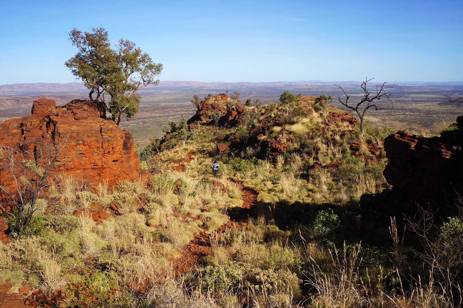
Although there are a few scrambles along the ridge, the walking is relatively easy. This really allowed Alissa and I to appreciate the beauty of this stunningly rugged Outback setting.

Although made from an entirely different type of rock than the mountains of the Stirling Range, the Hamersley Range is also made from the compacted sediment of an ancient sea bed. Several of the rocks show the characteristic wavy lines of sedimentary rock. In black and white, a rock from the Stirling Range and Hamersley Range may appear almost identical.

After all the excellent rugged walking, the final climb to the top of Mt Bruce is far less exciting, as it follows a series of switchbacks through dense bush. Although more straightforward than a scramble, the ascent is unrelenting, and the peak curves up in such a way that the summit is actually much further away than it appears.

There are also a number of times where the trail branches off in two directions. While confusing, they are actually just two alternate ways to get to the same point - one follows a switchback for a longer but easier climb, while the other is steeper but shorter.

Finally, after just under 2.5 hours of walking, Alissa and I made it to the summit of Mt Bruce, marked by one of the most impressively large cairns I've ever seen on a mountain. The views are uncommonly beautiful - given how flat Western Australia is, its rare to stand on top of a West Australian mountain and see a large mountain range stretching out in every direction.

Near the summit cairn is an informative plate identifying the many mountains surrounding Mt Bruce. While close to the summit itself, I felt it could have been put in a better location.

A faint but nevertheless well-trodden trail runs off to the south east. The area to the south east blocks the view from the summit to the mountains beyond, and it would have been preferable to have the plate located over there.
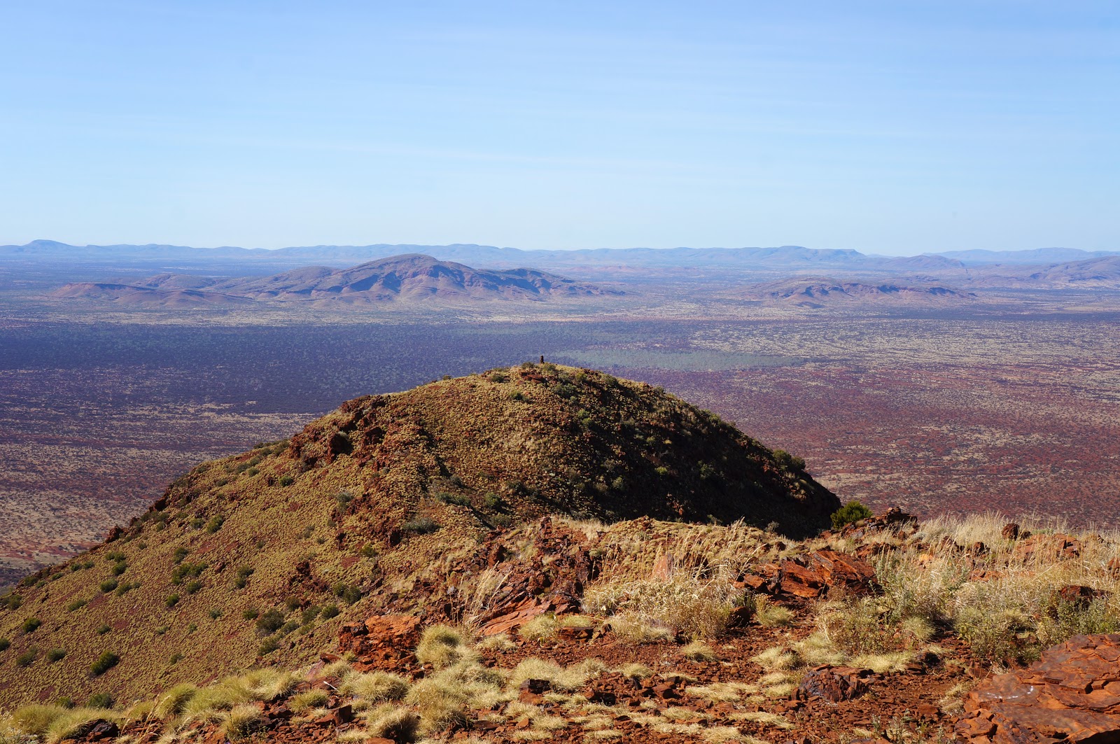
From the south east vantage point, one can see the nearby Mt Howeson, and somewhere to the right of the photo is Mt Meharry - indistinctly located within the range.


After spending a bit of time exploring the summit and making use of the phone reception, Alissa and I made our way back down the mountain. Almost entirely downhill, the return journey was faster and easier than the walk up, and Alissa and I were surprised to find we'd completed the return journey in 4.5 hours. Alissa had struggled with the constant ascending so we thought we might take the full 6 hours suggested by the brochure, howevert we really made up time on the way down.

Although the gorge walks are the main draw of Karijini National Park, Mt Bruce is a superb walk in its own right, and would rank highly as one of the most scenic, engaging and exciting mountain walks in Western Australia. Unlike the constant ascending steps of a mountain like Bluff Knoll, Mt Bruce had a good mix of steps, walking over rolling hills, scrambling up rocky sections and rugged ridge walking, and I would compare it favourably with mountain favourites like Toolbrunup Peak in the Stirling Range and Mt Ossa on the Overland Track. While the scrambling means this won't be for everybody, fans of adventurous mountain walks will find a lot to love about the Mt Bruce Summit Trail.


How was the 'vertical wall' part when you were coming down?
ReplyDelete