

A long, flat day walk on the Bibbulmun Track, this double hut section of the track takes walkers from Powerline Rd after Mt Cooke through to the Albany Hwy crossing at North Bannister via Nerang and Gringer Creek huts. Lacking elevation change and views, the dullness of the section is made worse by the fact it is recovering from the effects of an out of control controlled burn. Definitely one of the lesser stretches of the Track.
Distance: 28.6 km (one way)
Gradient: Continuously flat over its entire length, with only the gentlest of gradients at times.
Quality of Path: Well maintained, however many fallen trees across this stetch of track
Quality of Signage: Largely well signed, with the Waugal providing very clear directional information.
Experience Required: Some Bushwalking Experience Recommended
Time: 6-7 Hours, including two snack breaks
Steps: Some formal steps, as well as informal ones amongst rocky outcrops
Best Time to Visit: Winter-Spring
Entry Fee: No
Getting There: Access is via the Powerline Rd off Albany Hwy, easily identified by the large powerlines running overhead. You cannot drive down Powerline Rd however. Wearne Rd is located just north of the North Bannister Roadhouse. Entry Fee: No

On any long distance trail, there are gonna be really great, exciting days that you'll always treasure. Days like Waalegh to Ball Creek or walking the Monadnocks in the Darling Scarp section of the track come to mind, as well as walking through the Tingle forest from Frankland to Giants, crossing the Irwin Inlet on canoes from Peaceful Bay to Boat Harbour and the time Alissa and I had to wade across a shoulders deep Torbay Inlet in winter 2012.
Likewise, there are the dull sections. Sometimes they are mercifully short stretches where the track had little choice but to pass through, like the farmland between Northcliffe and Schafer. Others however seem to go on forever, and Powerline Rd to Wearne Rd is easily one of these lowlights of the Bibbulmun Track.

If doing a thru-hike, Powerline Rd would intersect the Bibbulmun halfway through the day from Mt Cooke campsite to Nerang, however as we have been mostly completing the Darling Scarp section as day walks, we had already completed the Mt Cooke part of the day in June 2015, using Powerline Rd as our exit point. We had meant to come back to this section sooner, however a controlled burn in the area escaped containment lines in September 2015, causing the area to be closed for many months. A long, burnt section was a hard sell to Alissa, and we finally got around to completing it a year later, as we had recently filled in the gap from the Perth Hills Discovery Centre to Dale Rd and this final stretch would mean we'd finished all of the track from Kalamunda to North Bannister.

Walking in from Powerline Rd is 2.2 kilometres following the Powerlines that intersect Albany Hwy. This hardly an exciting stretch of track, however it is at least very easy to follow to where the Bibbulmun Track intersects the road.
Initially, it looked like the damage had not been as bad as I had imagined, however once we were a few hundred metres into the forest, it was fairly obvious that it had been ravaged by the fires.

While severely burnt, this section was at least still engaging. It is often said that the first few years after a fire are some of the best for wildflowers, and there were certainly a lot of brilliant colours dramatically contrasted against the blackened stumps.

It is rare to find a section of the Bibbulmun Track through forested areas without a tree collapsed across the path, however the fire had obviously caused a higher than average number of trees to fall across the track. One was at a most inopportune location as it fell right near a fork in the road and made it appear like walkers should take the track to the right rather than go straight. Luckily, other hikers had constructed the makeshift arrow above to point walkers in the right direction, and we were very grateful for their kind assistance - who knows how long we would have walked the other way and which way we would have gone!

Initially however, we were slightly sceptical that we had indeed gone the right way as there were no markers for some while except for severely burnt ones. Seeing a freshly nailed in marker on a burnt out tree was such a relief.

Although the fallen trees had not been cleared, the area had at least been marked well by maintenance volunteers. A nice touch to this section was the track passing right through the middle of one of the burnt out trees.
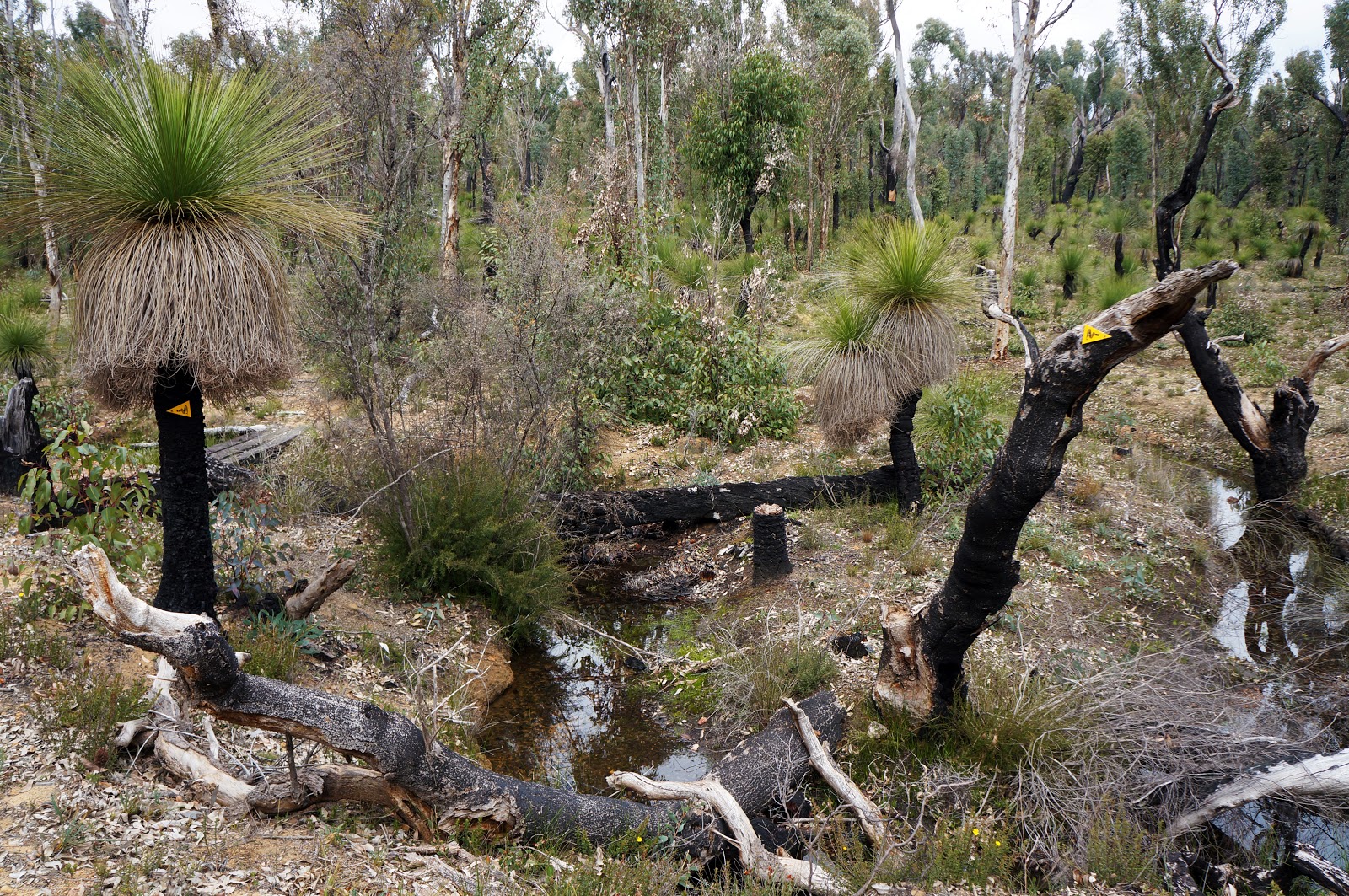
Some of the arrow locations were fairly novel, such as this somewhat whimsical combination on a grass tree and burnt out branch.

The whimsical markers are a good landmark, as it is only a few hundred metres from there until the track leaves the seemingly endless Jarrah forest and enter the Wandoo Woodlands that surround Nerang campsite (the hut can just be seen above to the right).

Right before reaching the hut, the track crosses a small stream on a low key bridge as it leads to the fairly idyllic scene around the campsite.

Nerang's hut is of the large 'Deep South' style, but has a peculiar feature - fat, round logs as the front pillars. I don't recall ever seeing this on any of the other Deep South huts before, and made me wonder if it was perhaps a prototype design that was altered for the other huts or a slightly makeshift repair job due to damage in the past.

After stopping for brunch and chatting to another hiker who was also heading towards North Bannister, Alissa and I continued on, eager to make use of the flat terrain and keep a good pace. The 2002 North Half guidebook had also promised this section to have 'some of the very best wandoo creek systems along the whole length [of the track]'. The initial showing of Wandoo near Nerang gave us some hope, but it would prove to be rather false.

Much of the walk was through more Jarrah forest, with a lot of it fairly burnt.

The burnt bit wasn't the problem - even the not as burnt bits were drearily grey and boring, with few wildflowers to liven things up. Walking over fallen trees became the exciting things to look forward to, and we hoped to eventually see some Wandoo as we continued along.

Eventually, we did reach a section of Wandoo creek systems, however I felt the track alignment didn't make the most of this. We could clearly see that a creek bed must have been somewhere nearby, however the track was so far away from the creek we were basically just walking at the outskirts of the Wandoo Woodlands, with Wandoo to our left and Jarrah to the right. After having walked through Wandoo Woodlands along gullies and creeks between Waalegh and Ball Creek just the week before, this was far from the 'best wandoo creek systems' the book had touted.

To make things worse, the Wandoo sections were still hugely outnumbered by the stretches through Jarrah, and it got the point that even the slightest unique feature became a highlight, such as seeing some cairns placed on a small granite slab. Alissa and I joked that this was Little Sullivan Rock, named after the much more impressive expanse of granite seen between Monadnocks and Mt Cooke campsite.

The endless Jarrah and dull wildflower-free grasslands continued on in their monotonousness, with bits of charred bark to break up the grey and khaki. Thankfully the easiness of the terrain had meant we had managed to maintain a pace of under 10 minutes per kilometre, but the section's length and the lack of excitement had us begun to wear us out, slowing us and making it a bit of a mind game to keep us pushing towards our destination.

Sighting a gravel road signalled that we were not far from the end. This is a section of Wearne Rd, with the Bibbulmun continuing on the other side towards Gringer Creek campsite.

After descending slightly, the track heads through a section filled with fallen trees - the one pictured above created an interesting arch to walk through.

Finally, we reached Gringer Creek, the last hut along the Bibbulmun Track north of Albany Hwy. Being close to North Bannister must had been the reason it was one of the smaller 'Standard' style huts.

From the hut, a spur trail leads to North Bannister Roadhouse. For walkers tired after a boring day of walking, being able to have a burger at the Roadhouse would be like Manna from Heaven. We've eaten there before and can vouch that it would be worth the short walk - especially for thru-hikers who would have been on a week of dehydrated meals by this point.

Although we could have parked our car at North Bannister, we decided to park at Wearne Rd instead as it meant we would cover a bit of the next day's walk to White Horse Hills that we wouldn't have to do next time. From Gringer Creek, the track loops back through forest heading towards Wearne Rd and Albany Hwy. Although typically dull and scrappy Jarrah forest, Alissa and I were delighted to hear noising Black Cockatoos screeching and flying from tree to tree in this area.

1.2 kilometres from the hut, the track crosses Wearne Rd. We had initially considered maybe continuing on the track to the Albany Hwy crossing, however we were pretty tired and ready to go by this point and turned right down Wearne Rd to Alissa's car.

The walk down Wearne Rd was fairly short, and we were at the car in under 10 minutes, feeling very accomplished to have completed everything from Kalamunda to North Bannister and to have walked today at a cracking average pace of 11:14 minutes per kilometre.
Most of all however, we were just happy to have finished this long section that stands out as one of the dullest stretches of the Bibbulmun we have walked to date. Although very easy compared to most other parts of the track, the scenery here is so dreary and unchanging that I would definitely not recommend this section to anyone except to completists looking to get an End to End certificate, and definitely not to anyone being introduced to the track. With so many other great options like Kalamunda to Mundaring Weir, the overnight from Perth Hills Discover Centre to Dale Rd and the Monadnocks/Mt Cooke sections accessible from Sullivan Rock, stick to the good ones first before tackling this long double hut stretch. I'm gonna have to say it: sometimes, just sometimes, the long way is not better.


Hiking is what that makes me feel light since by spending much time in the wilderness, it takes you away from the worries. this place looks nice and one can spend hours exploring this natural hub.
ReplyDelete