
A superb but challenging day walk, the trail to Toolbrunup Peak takes walkers to the summit of the second highest mountain in the Stirling Range. Steeper and wilder than Bluff Knoll, the trail's initially moderate ascent passes through forest before a scramble through two boulder fields and steep rocky ledges on the way to the summit. With breathtaking 360° views across the entire range, this is a must do for experienced walkers.
Distance: 4 km (return)
Gradient: Continually uphill, with some very steep sections requiring free hands for scrambling.
Quality of Path: Relatively clear and straightforward, although the loose gravelly scree can be slippery. The rockier scramble sections on the boulders have no set path and have to be navigated with care.
Quality of Signage: Good and informative trailhead, with metal waypoint signs from the boulder field onwards
Experience Required: Previous Bushwalking Experience Required. This is a very hard walk in steep and potentially dangerous terrain known for its unpredictable weather, with large sections of the walk requiring scrambling. Highly unsuitable for beginners or those with known knee problems
Time: 3-4 Hours
Steps: No formal steps, but a lot of climbing up large boulders
Best Time to Visit: Autumn and Spring, and milder Winter days
Entry Fee: No
Entry Fee: No
Getting There: Access to Toolbrunup is via Toolbrunup Rd, which turns off west from Chester Pass Rd. Toolbrunup's carpark is at the end of the road.

Driving north from Albany up Chester Pass Rd, mighty Toolbrunup looms large in the Stirling Range. Although in second place behind the 1099 metre high Bluff Knoll as the range's tallest mountain, Toolbrunup's central location and distinctive peak shape allows it 1052 metre height to tower above the surrounding landscape. Although Bluff Knoll is the most famous tourist attraction within the National Park, the tougher, wilder climb up Toolbrunup Peak is considered by many to be the best in the Stirling Range. Having tackled the short but difficult summit trail of Talyuberlup Peak as warm up a fortnight earlier and with highly favourable weather on our side, Alissa and I returned to Stirling Range National Park to complete this formidable mountain walk.

The trailhead is located at the end of Toolbrunup Rd - the immediate left turn after Moingup Springs Campground and the Ranger's Station. A decent sized car park is located at the end of the road.

Although Talyuberlup's trail similarly began in a forested area, it was much thinner and gave way to montane heathland much earlier than Toolbrunup. Perhaps due to the presence of a gully running alongside the track, Toolbrunup's forests are much denser and taller (though far from Karri or Tingle forests). Additionally, Toolbrunup's trail is made of considerably harder, gravelly scree compared to the washed away clay-like conditions of the early sections of Talyuberlup. This firmer ground and an initially gentler ascent makes Toolbrunup's path a bit easier to walk up, but the loose scree can make the return journey down the mountain a bit slippery.

The track crosses several sections of open scree. Having heard of the track's difficulty, we assumed we would have to climb one of these slippery slopes, however the path sensibly avoids doing so.

A common feature of the rocks all the way up to the summit is the appearance of ripple-like grooves, and these give a clue as to the Stirling Range's origins. The sedimentary rock that makes up the Range had once been formed in a shallow sea that was then forced upwards millions of years later during the split of Australia and Antarctica. In an amazing twist of fate, the bottom of a sea from 1.2 billion years ago can now be found over a 1000 metres above sea level. Just extraordinary.

As the trail ascends, the terrain become a bit rockier and steeper, though still no quite a scramble. The trail passes crags and massive boulders that have rolled down from the peaks, making for very interesting terrain.


With much of the first part of the trail surrounded by forest, it is a real treat to enter an area of open scree and become privy to outstanding views of the mountain's peak.

As awe-inspiring as the view of the mountain may be, walkers will still need to pay attention to the slipperiness of the scree. While the track cuts across the scree, it is on a very steep slope to the gully down below and would not be a very fun climb back up.

As we reentered a forested area, the sound of water became apparent, as well as the increasing prevalence of moss-covered rock.

Just to the right of the track was a small stream. While the path was following the course of a gully, I could only follow the flow of water a short distance upstream, and I wondered if this was perhaps a spring. Given that Toolbrunup is thought to mean 'place that has water when all else is dry', a spring would seem to shed some light on the mountain's etymology.

A short distance after the the stream, the trail increases in difficulty as it enters the first of two boulder fields. I knew to expect this from photos and videos online, but it would be a shock for those caught unaware; indeed, as we came down the mountain, we head a woman utter a startled 'oh my God!' upon seeing the fields for the first time.

Up to this point, the trail was probably no more difficult that a very steep section of the Bibbulmun Track, but with not set path, unstable footing and the need for free hands to help in the scramble up, the boulder fields are definitely challenging (but far from insurmountable) terrain.


Upon finishing the first long boulder field, the track passes through some heath before entering a second shorter but steeper boulder field.

Walking up the boulders, the crag of Toolbrunup's summit towers overhead, teasing that we were almost at our destination.

For most of the trek, the trail is protected by the mountains surrounding it. A few metres beyond the boulder field, the track reaches a pass that provides views of many of the other western peaks. At this point, we were exposed to extremely strong winds that would accompany us all the way to the summit. Our hats repeatedly blew off and there were times where it felt like you could be blown over if it got any stronger - walkers should be aware of this and take extra care from this point on.

In spite of the boulder fields, the path to the summit had not been quite as difficult as the scramble section of Talyuberlup. This would change in the final scramble to Toolbrunup's summit with similarly tricky terrain to the smaller mountain. A particularly steep climb looked to be on an incline in excess of 60° (maybe even more!), and required a bit of a climb to get through.


Once through this climb, the trail continues on along a ledge overlooking the western peaks. Metal markers seen earlier in the boulder field continue to provide clear waypoints to the summit.

Before reaching the summit, the trail passes a rocky formation often photographed by those who have completed the climb. Appearing like a large chair, the rock provides a balcony from which to view the great expanse of the western peaks. The winds here were incredibly strong - my hat blew off within seconds of standing in place, and I held onto the rock with both hands for safety's sake.

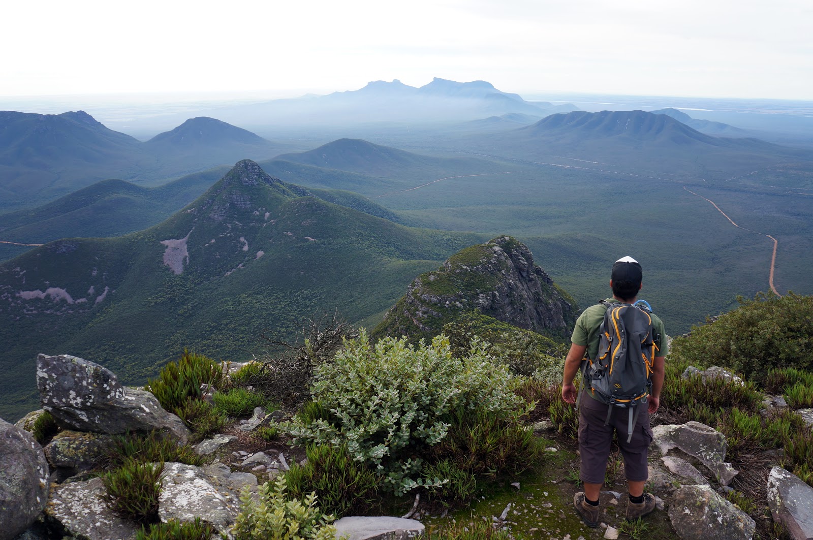
Just a few metres beyond the rocky balcony, the trail finally reaches Toolbrunup's summit. Unlike the mist-covered summit that greeted us during our climb to the top of Talyuberlup, we could not have asked for better weather. The views from Toolbrunup are nothing short of extraordinary; you can see the entire expanse of the Stirling Range from here, including the distinctively squarish shape of Bluff Knoll in the distance.

The actual highest point of the summit goes to a much smaller point that Talyuberlup, and the summit cairn is smaller than the large bird's nest-like structure sitting atop the shorter mountain. This definitely contributes to Toolbrunup's pointy appearance from afar.

Alissa and I stayed at the summit for half an hour as we enjoyed the lovely views and weather. The trek down the mountain was faster than the ascent, however it puts a lot of pressure on your knees. Even the relatively easy parts were made a bit trickier to walk due to the loose scree, and we were grateful to have had trekking poles to help us. In all, it took us 2 hours to reach the summit and 1.5 hours to get back down.
When we got the end, Alissa and I discussed what we thought about the trail. Although it was fairly difficult and Alissa's fear of heights made it a bit scary for her in places, she agreed that this was a superb walk, and that the views from the summit more than make up for the challenge of getting there. This could also be said of trails like the Granite Skywalk in the Porongurups, but what makes Toolbrunup even better is that the journey there is interesting as well, with ever-changing scenery and challenges along the way. This walk would easily rank highly as one of our favourite days to date - right up there with Torndirrup National Park's Bald Head Trail and the Blue Mountain's Grand Canyon Walk. As with the Bald Head Trail and Talyuberlup Peak, I would actively discourage anyone with little to no bushwalking experience from attempting Toolbrunup. For experienced walkers however, Toolbrunup Peak should be an essential trail while in the Great Southern.

Driving north from Albany up Chester Pass Rd, mighty Toolbrunup looms large in the Stirling Range. Although in second place behind the 1099 metre high Bluff Knoll as the range's tallest mountain, Toolbrunup's central location and distinctive peak shape allows it 1052 metre height to tower above the surrounding landscape. Although Bluff Knoll is the most famous tourist attraction within the National Park, the tougher, wilder climb up Toolbrunup Peak is considered by many to be the best in the Stirling Range. Having tackled the short but difficult summit trail of Talyuberlup Peak as warm up a fortnight earlier and with highly favourable weather on our side, Alissa and I returned to Stirling Range National Park to complete this formidable mountain walk.

The trailhead is located at the end of Toolbrunup Rd - the immediate left turn after Moingup Springs Campground and the Ranger's Station. A decent sized car park is located at the end of the road.

Although Talyuberlup's trail similarly began in a forested area, it was much thinner and gave way to montane heathland much earlier than Toolbrunup. Perhaps due to the presence of a gully running alongside the track, Toolbrunup's forests are much denser and taller (though far from Karri or Tingle forests). Additionally, Toolbrunup's trail is made of considerably harder, gravelly scree compared to the washed away clay-like conditions of the early sections of Talyuberlup. This firmer ground and an initially gentler ascent makes Toolbrunup's path a bit easier to walk up, but the loose scree can make the return journey down the mountain a bit slippery.

The track crosses several sections of open scree. Having heard of the track's difficulty, we assumed we would have to climb one of these slippery slopes, however the path sensibly avoids doing so.

A common feature of the rocks all the way up to the summit is the appearance of ripple-like grooves, and these give a clue as to the Stirling Range's origins. The sedimentary rock that makes up the Range had once been formed in a shallow sea that was then forced upwards millions of years later during the split of Australia and Antarctica. In an amazing twist of fate, the bottom of a sea from 1.2 billion years ago can now be found over a 1000 metres above sea level. Just extraordinary.

As the trail ascends, the terrain become a bit rockier and steeper, though still no quite a scramble. The trail passes crags and massive boulders that have rolled down from the peaks, making for very interesting terrain.


With much of the first part of the trail surrounded by forest, it is a real treat to enter an area of open scree and become privy to outstanding views of the mountain's peak.

As awe-inspiring as the view of the mountain may be, walkers will still need to pay attention to the slipperiness of the scree. While the track cuts across the scree, it is on a very steep slope to the gully down below and would not be a very fun climb back up.

As we reentered a forested area, the sound of water became apparent, as well as the increasing prevalence of moss-covered rock.

Just to the right of the track was a small stream. While the path was following the course of a gully, I could only follow the flow of water a short distance upstream, and I wondered if this was perhaps a spring. Given that Toolbrunup is thought to mean 'place that has water when all else is dry', a spring would seem to shed some light on the mountain's etymology.

A short distance after the the stream, the trail increases in difficulty as it enters the first of two boulder fields. I knew to expect this from photos and videos online, but it would be a shock for those caught unaware; indeed, as we came down the mountain, we head a woman utter a startled 'oh my God!' upon seeing the fields for the first time.

Up to this point, the trail was probably no more difficult that a very steep section of the Bibbulmun Track, but with not set path, unstable footing and the need for free hands to help in the scramble up, the boulder fields are definitely challenging (but far from insurmountable) terrain.


Upon finishing the first long boulder field, the track passes through some heath before entering a second shorter but steeper boulder field.

Walking up the boulders, the crag of Toolbrunup's summit towers overhead, teasing that we were almost at our destination.

For most of the trek, the trail is protected by the mountains surrounding it. A few metres beyond the boulder field, the track reaches a pass that provides views of many of the other western peaks. At this point, we were exposed to extremely strong winds that would accompany us all the way to the summit. Our hats repeatedly blew off and there were times where it felt like you could be blown over if it got any stronger - walkers should be aware of this and take extra care from this point on.

In spite of the boulder fields, the path to the summit had not been quite as difficult as the scramble section of Talyuberlup. This would change in the final scramble to Toolbrunup's summit with similarly tricky terrain to the smaller mountain. A particularly steep climb looked to be on an incline in excess of 60° (maybe even more!), and required a bit of a climb to get through.


Once through this climb, the trail continues on along a ledge overlooking the western peaks. Metal markers seen earlier in the boulder field continue to provide clear waypoints to the summit.

Before reaching the summit, the trail passes a rocky formation often photographed by those who have completed the climb. Appearing like a large chair, the rock provides a balcony from which to view the great expanse of the western peaks. The winds here were incredibly strong - my hat blew off within seconds of standing in place, and I held onto the rock with both hands for safety's sake.

Just a few metres beyond the rocky balcony, the trail finally reaches Toolbrunup's summit. Unlike the mist-covered summit that greeted us during our climb to the top of Talyuberlup, we could not have asked for better weather. The views from Toolbrunup are nothing short of extraordinary; you can see the entire expanse of the Stirling Range from here, including the distinctively squarish shape of Bluff Knoll in the distance.

The actual highest point of the summit goes to a much smaller point that Talyuberlup, and the summit cairn is smaller than the large bird's nest-like structure sitting atop the shorter mountain. This definitely contributes to Toolbrunup's pointy appearance from afar.
Alissa and I stayed at the summit for half an hour as we enjoyed the lovely views and weather. The trek down the mountain was faster than the ascent, however it puts a lot of pressure on your knees. Even the relatively easy parts were made a bit trickier to walk due to the loose scree, and we were grateful to have had trekking poles to help us. In all, it took us 2 hours to reach the summit and 1.5 hours to get back down.
When we got the end, Alissa and I discussed what we thought about the trail. Although it was fairly difficult and Alissa's fear of heights made it a bit scary for her in places, she agreed that this was a superb walk, and that the views from the summit more than make up for the challenge of getting there. This could also be said of trails like the Granite Skywalk in the Porongurups, but what makes Toolbrunup even better is that the journey there is interesting as well, with ever-changing scenery and challenges along the way. This walk would easily rank highly as one of our favourite days to date - right up there with Torndirrup National Park's Bald Head Trail and the Blue Mountain's Grand Canyon Walk. As with the Bald Head Trail and Talyuberlup Peak, I would actively discourage anyone with little to no bushwalking experience from attempting Toolbrunup. For experienced walkers however, Toolbrunup Peak should be an essential trail while in the Great Southern.


0 comments:
Post a Comment