

Day two of an eight day hike on the Bibbulmun Track, the walk from Blackwood to Gregory Brook can be divided into two segments - the first following the Blackwood River, with the second along a railway formation through transitional Jarrah forests. Featuring the steep descent of Cardiac Hill, a climb to Millstream Dam and the first Karris of the Track, the idyllic campsite along the Gregory Brook provides a lovely end to the day's walking.
Distance: 18.2 km (one way)
Gradient: Very steep descent from Blackwood campsite, then moderately hilly with flat sections along rail formations
Quality of Path: Largely clear and well maintained.
Quality of Signage: Largely well signed, with the Waugal providing very clear directional information.
Experience Required: Some Bushwalking Experience Recommended
Time: 7 Hours, including lunch
Steps: Many formal steps, as well as informal ones amongst rocky outcrops
Best Time to Visit: Winter-Spring
Entry Fee: No
Getting There: This section was walked from campsite to campsite, however walkers looking for a single overnight on the track could start at the Southampton Bridge on Southampton RdEntry Fee: No

The first night out of the Track is always the worst, and for Alissa the windy night at Blackwood was no exception. Although we were warm within our tent set up in the shelter, the lack of a real bed definitely got to her. While I fared better, we nevertheless were somewhat restless throughout the night. Our Sea to Summit sleep systems are definitely comfortable and a huge improvement from our previous kit, however the Ultralight mats are very noisy and our restlessness must have been slightly annoying for our hut-mates. Things would improve over the rest of our walk, but we definitely felt a bit self-conscious about the noise.
Waking up to sunrise over the Blackwood Valley was a lovely experience. If you framed your point of view perfectly, you could cut out all the burnt bits and get a sense of how spectacular a view this would have been before the fire. Had we been here the day before, we would have been greeted by mist throughout the valley, but it was nevertheless a great start to the day.

Blackwood's toilet is also perfectly located to take in the views, and I can imagine many a hiker has found themselves fortunate enough to be at Blackwood by themselves and have left the door open to enjoy the scenery.

Although we had all gotten up around the same time (just before 6am), Jerry and Helle, who had been walking from Kalamunda and North Bannister respectively, were definitely much faster at packing than we were and were off while we were still sorting out our tent. After packing up and saying goodbye to the pair of walkers heading to Balingup, Alissa and I followed the path from the campsite back onto the Track proper.

Almost immediately after leaving the campsite, the track takes you to one of the most infamous hills of the track - Cardiac Hill.

Although descending via switchbacks and some steps, Cardiac Hill is nevertheless very steep, and Alissa and I were relieved that we had trekking poles as it would not be difficult to make a wrong step and fall here, especially in wetter weather.


Along the descent, some of the less steep sections offer walkers an opportunity to take in the surrounding landscape - a consolation that would be very much welcomed by hikers heading in the other direction.

In fact, when we got to the bottom, Alissa and I agreed that the supposed debate about whether it is harder going up or down Cardiac Hill seemed overstated; it would definitely be worse going up! Going downhill, the only things you have to be aware of is that descending steeply can be a shock to the knees and that you need to watch your footing. Going up would really get the heart pumping, take some time and then the 'reward' would be the desolation that surrounds Blackwood. Hardly inspiring.

After descending Cardiac Hill, the Bibbulmun passes by several rural properties with horses watching us as we walked by. The pair of hikers who walked in the other direction to Balingup has told us about how beautiful the horses were, but all I could think when I saw them were the words 'back in the 90s, I was in a very famous TV show!'.

Near the horses, the Blackwood River runs close to the track, and remains a near constant companion for the first six kilometres of the walk.

Before the Southampton Fires, a major feature of this early part of the walk was the Southampton Homestead. Constructed in 1862, it was one of the earliest buildings in the area, however it was sadly destroyed in the blaze. The track does still however pass through the property boundary, going through two gates before continuing on.

The lushness of the river environment resulted in the area being filled with flowers both wild and not so wild. The first few years after a fire often bring the best blooms, and this was clearly the case as we walked through some beautiful areas along the river.

The track in this section was very muddy, and although we had been warned that it would present something of a challenge, we were shocked to find the track completely inundated at one point, being more than ankle deep! Thankfully, the pair heading in the other direction had warned us about this and informed us of an alternative.

Just to the right of the track, walkers had created an ad hoc diversion around the flooded section, and it was relatively easy to discern how to get through to the other side.
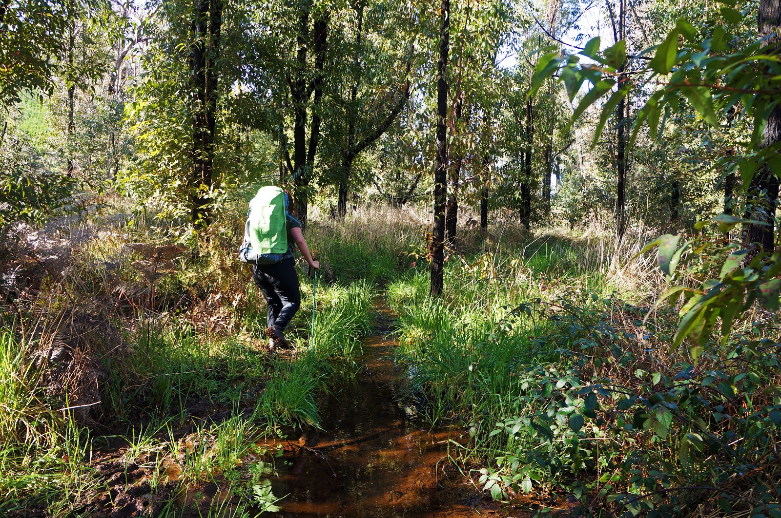
Although the track continued to feature fairly wet sections, not were as bad as the one we walked around, and we generally were able to find a way through the very muddy track.

The Bibbulmun makes use of the Southampton Traffic Bridge to cross over to the other side of the Blackwood River.

For the next kilometre or so, the Bibbulmun follows a forestry road along the Blackwood River before veering right.

Having come down to the river at Cardiac Hill, it was almost inevitable that we would have to rise up again, with the Bibbulmun climbing up the other side of the valley via a switchbacks on a forestry road. Although it continued for two kilometres up a moderately steep incline, it was no where near as bad as Cardiac Hill would have been to ascend.

The climb was made worthwhile thanks to the fact it offers the last views of the Blackwood Valley before heading south west.

Near the top of the hill is the Millstream Dam, which is the water supply for Bridgetown. The dam is not as easily accessed as some of the other more walker-friendly dams of the South West, with signs indicating that trespassers will be prosecuted.

From here, the Bibbulmun begins to follow an old rail formation for much of the rest of the day's walking. Rail formations are a major component of walking in the Southern Forests, and I like to think of them as the freeways of the forest; their relatively gentle gradients often mean easy walking and a speed boost. The downside however is that they sometimes lack views and go on for so long that you'll be actually wanting to walk in more challenging terrain for a bit of a change of pace! The mix of hilly sections tempered by rail formations proved to be a rough template that the Track follows all the way through to Pemberton.

Early on, the track provides views of the Millstream Dam waterbody before heading deeper into the surrounding forest.

The forrest here is predominantly Jarrah and Marri, and features the dense understorey common to the southern Jarrah forests. We could definitely tell that we were heading deeper into the High Rainfall Zone that can support the Karri forest.

The rail formation went on for a long time, and we encountered a lot of walkers along this stretch. The first two we encountered were a father and his young son who were walking to Blackwood.
"Ooh, you've got quite the climb ahead of you!" I said, thinking about Cardiac Hill. Apparently everyone had kept saying that (presumably Jerry and Helle included), and the child's face clearly showed a lack of excitement for the challenge to come.

As we came close to a some gullies, the Jarrah gave way to white barked trees that I initially though were Wandoo, but would later discover were another Eucalypt species known as Bullich. It is interesting how these similar looking trees can be found in similar places, as they both dependably grow near water courses. Note also in the photo above just how massive the Kingia Grass Trees were in the section - they truly earned being called trees!
At this point we decided to have our lunch. As we were preparing our sandwiches, a massive group of 19 Eastern European hikers walked past us heading to Blackwood, and we were relieved to not have had to share a hut with them as they were quite a noisy bunch who had obviously not read the Bibbulmun Track rules that require any group of eight or more to provide a Notice of Intent to DPaW. There were not supposed to be any groups on the track according to the Bibbulmun Track website, and I felt sorry for the hikers who had to share Gregory Brook with them.

After lunch, the Bibbulmun leaves the rail formation and turns down Wetherly Rd. South of this road, walkers encounter the first Karri trees along the track. Although they were no where near as tall or as plentiful as those we'd encounter over later days, it was nevertheless something of a milestone.

The sight of Karri is brief however, and the Bibbulmun follows old vehicle tracks through lush Jarrah forest for much of the rest of the day.

There were a number of fallen trees in this section, but nothing overly challenging - definitely not anything in the realm of having to find our way around a Giant Tingle like we did between Giants and Frankland last year, or the fallen Karri we encountered on the way to Warren Hut.

Surrounded by towering Marri trees, Gregory Brook campsite was a welcome change from the bleakness of Blackwood. Although not deep in the Karri forest, the lushness of the area around Gregory Brook was definitely something of model for the huts we would be staying in for the rest of the walk, which were almost always right by a river or gully of some kind.

Perhaps due to its sheltered location, Gregory Brook is not one of the larger Deep South-style huts, and instead is an example of the Stretch design - a slightly bigger version of the Standard huts located in the north. At this hut, we met Sonya and Peter - a couple from New South Wales doing an End to End who had had a rest day at Gregory Brook and would be sharing the huts with us from here to Pemberton.

After setting up our stuff and relaxing for a bit, Alissa and I went to explore the area around the campsite. The hut faces Gregory Brook itself - an attractive stream that flows with a gentle trickling that is very peaceful.

At the time, I think Alissa and I found the Blackwood to Gregory Brook a bit of a trudge due to the muddiness near the Blackwood River and the long time spent along the railway formation. However, we would come to appreciate the shorter walking distance and the balance of hilliness and relatively easy walking that the day offered, and I think there was a lot to like about the day. Having seen some somewhat uninspiring campsites in the Northern Half, such as Ball Creek, Canning and Gringer Creek, the opportunity to stay in such a lovely location far off the beaten track makes Gregory Brook an excellent reward for the day's walking, and a definite step up from Blackwood in its current state.


Sensational photos and good to hear the water table is up near the blackwood. I was curious how Blackwood had fared after those fires.
ReplyDeleteYeah, it was very wet. Such a shame about Blackwood though - I've seen some photos of before the fire and its like chalk and cheese (or rather charcoal and cheese).
Delete