

Day three of an eight day hike on the Bibbulmun Track, Gregory Brook to Donnelly River Village is a day of transition, with walkers entering the first sections of lush, dense forest dominated by Karri. Following several rail formations and crossing old wooden bridges, the day features some spectacular forest walking before leading to Donnelly River Village - a magical place that is home to tame kangaroos and emus.
Distance: 22.5 km (one way)
Gradient: Relatively even for most of its length, with a few short, sharp ascents towards the end
Quality of Path: Largely clear and well maintained, though there is one massive fallen tree towards the end that blocks the track.
Quality of Signage: Largely well signed, with the Waugal providing very clear directional information.
Experience Required: Some Bushwalking Experience Recommended
Time: 6 Hours, including snack break
Steps: Some formal steps, as well as informal ones amongst rocky outcrops
Best Time to Visit: Winter-Spring
Entry Fee: No
Getting There: This section was walked from campsite to campsite, however walkers looking for a day walk option could walk from Karri Gully to Donnelly River Village. Karri Gully is accessible from Brockman Hwy, west of the Bridgetown Forest Park and runs as a 200m spur to the Bibbulmun Track. Entry Fee: No

Day Three of our eight day hike from Balingup to Pemberton was set to be a milestone day; although we had seen scatterings of Karri on the way to Gregory Brook, the walk from Gregory Brook to Donnelly River Village is the first day on the Bibbulmun that truly immerses walkers in the towering Karri forests, and as such I was eager to get going earlier than we had the day before. Alissa and I brainstormed a plan that was much more streamlined and efficient, and although we only shaved 10-15 minutes off yesterday's time, it was a system that would help us get even faster as our hike progressed.
Not far after leaving the hut, the Bibbulmun passes by a handful of very mature Grass Trees. We had seen some impressive Kingias the day before, and today we were treated to impressively tall Xanthorrhoeas that towered overhead - well and truly earning the name 'Grass Tree'.

Initially, the walking runs along on vehicle track in Jarrah forest that is very similar to the area around Gregory Brook, being quite lush and having a dense understorey.

The forest grew more and more dense, and suddenly we found ourselves in transitional forests with a mix of Jarrah, Karri and Marri all growing together. At this point, the Bibbulmun features a spur trail to Karri Gully. Being only 200 metres off the track, it seemed like a reasonable enough side trip to check it out.

Featuring a day use area, Karri Gully is quite a lovely spot that featured the first views of Karri-dominated forest we would see along our hike. In the 1988 alignment of the Bibbulmun, the track went right through Karri Gully and then along Brockman Hwy, and although it is now no longer an official part of the Bibbulmun it does provide a good vehicle access point and can be used to do a day walk version of this walk to Donnelly River Village. For End to Enders or those continuing on to Pemberton or Northcliffe, this is probably an unnecessary side trip, as the Bibbulmun spends over a week in the Karri Forests and there are spots just as pretty as Karri Gully all the way through to Northcliffe.

After our quick visit to Karri Gully, Alissa and I continued back on the Bibbulmun in the mixed forests we had encountered earlier. Karris were still less dominant in the section, completely disappearing from the forest as we came closer to the Brockman Hwy crossing.

Crossing Brockman Hwy brought about an abrupt change in the forest with the Jarrah on the southern side having obvious signs of bushfire damage.

Although the area has been quite significantly burnt, the forest looks to have been recovering very well, and Alissa and I found the contrast of the rich greenery against the blackened trees to be quite an interesting and engaging section of the walk.


Continuing along, the fire damage became less severe and less obvious. This was largely due to the presence of Karri trees. When we visited the badly burnt Boorara-Gardner National Park earlier this year, we had noticed that the fact Karri trees peel off their outer layers meant that the trees seem less obviously burnt than Jarrah, which remains blackened and charred long after a fire. This was the case with this burnt section of the Bibbulmun, with the transition to Karri forest reducing the fire's visual impact.

Just as crossing Brockman Hwy brought about an abrupt transition, crossing under powerlines and over a service road resulted in yet another change of scenery.

Following the old Willow Bridge railway formation, the Track enters an area of particularly wet and lush Karri forest with the extremely dense understorey common to the wettest parts of the South West's High Rainfall Zone.

The track crosses a number of creeks and brooks, many over repurposed rail bridges. This is wet country after a particularly wet winter, and it is not hard to imagine that this area was once a rainforest before the South West dried out.

Occasionally, the understorey opens up a bit, allowing walkers to really appreciate the beauty and grandeur of the massively tall Karri trees.

After being immersed in the dense Karri forest for many kilometres, the Bibbulmun approaches the camping area of Willow Springs. There is a lot of history on display here as it was once the site of a mill, and introduced Pine trees remain as remnants of an old Arboretum. For eagle-eyed Bibbulmun Track historians however, the sign above will be of great interest. I can't recall ever seeing this type of marker on the Bibbulmun Track, however it bares a striking resemblance to the markers used on the Kattamordo Trail (see Life of Py's guide) and dates the sign to having been in place sign at least the 1988 alignment, and quite possibly the 1979 alignment given that the Waugal was already introduced in '88.

After passing the camping area of Willow Springs, the trail continues along the old formation. On the day we walked the track, the Karris were shedding their bark, creating an interesting forest landscape to walk through.

Just beyond the peeling bark, Alissa and I found what looked to be an old railway platform and we decided to stop for a quick snack break, as the promise of a hot meal at Donnelly River Village would serve as our real lunch.

Clearing the Willow Gully area, the Pines disappeared and were were once again in lovely, dense Karri country as we travelled along the old railway formation.

A hiker we encountered at the Gregory Brook hut heading to Balingup had told us about the above set of steps that appear suddenly in the forest. It is fairly obvious that in the past two railway lines crossed each other at this point of the forest, with the Willow Bridge Formation possibly crossing over on a bridge. Now, the track turns at a sharp 90 degree angle as it descends the steps and continues on along the other formation.

Some of the old rail bridges here are quite substantial, and provide for some very scenic walking.

Peter and Sonya, the End to Enders we met at Gregory Brook, would later comment on how blue the waters are in the Karri forests - especially when compared to the somewhat clear water more common the Northern Half. This is presumably due to better drainage in the Laterite and Granite dominated north compared the loam of the Karri forest.

Leaving the dense Karri forest and returning to Jarrah, Alissa and I encountered a particularly muddy stretch of track which continued sporadically in this fastion for a few hundred metres.

From the muddy section, the Bibbulmun crosses over the management boundary of the Blackwood District and enters the Donnelly District.


Upon entering the Donnelly District, walkers encounter the Donnelly River and its tributaries. The river remains a major companion for much of the walk from here to Beedelup, and would provide many a lovely view over the next few days.

A downside of being on a railway formation for an extended length of time is that it can be hard to work out exactly where you are, and you start becoming desperate to find the next obvious landmark. Walking along a gravel road and seeing what we thought must have been the bridge over the Donnelly River got us excited - it was just a bit over 5 kilometres from here to the end.
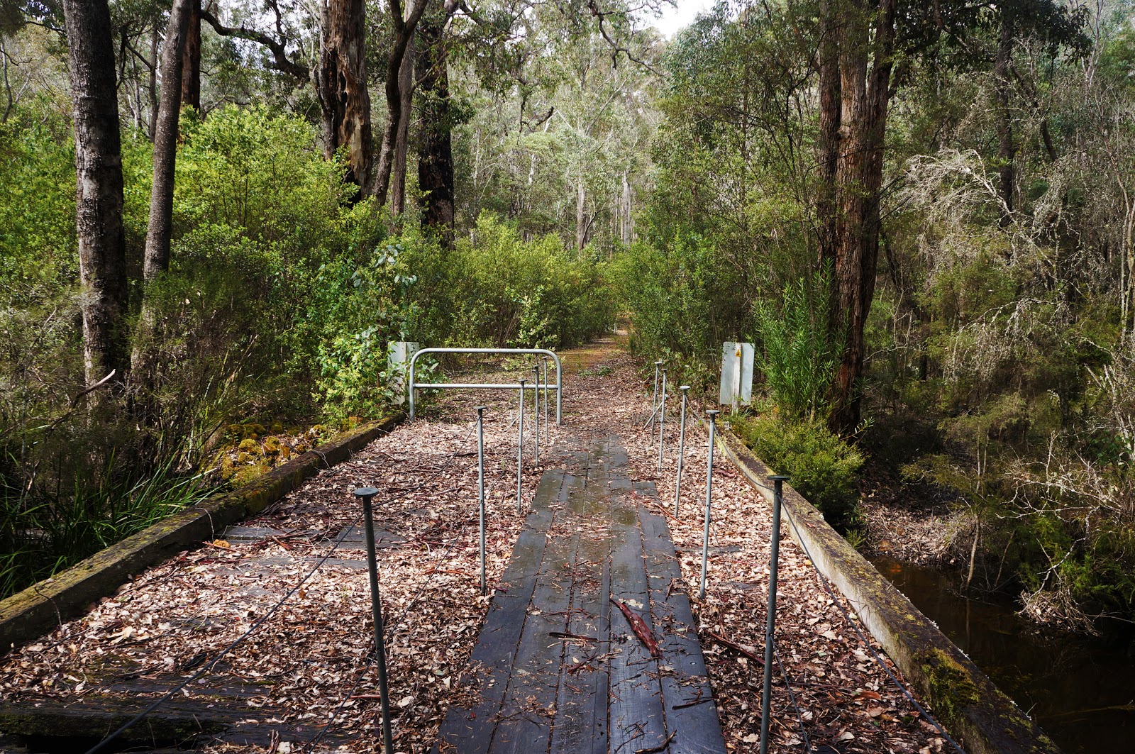
Unfortunately we were very wrong. That was not the bridge over the Donnelly River, and when we came upon the wooden bridge pictured above it became fairly clear that we had misjudged how far we had travelled and we had about another hour of walking more than we had anticipated. As lovely as crossing the old bridge was, we felt a bit demoralised by our mistake. This only served to make the last few kilometres to Donnelly River Village all that more mentally challenging.

After crossing the bridge, the track continues on road called Snake Rd almost all the way into the village. This proved to be very fatiguing walking - where we had become used to the softness of the Karri loam along the track, we now had hard, compacted gravel road to walk on, and Alissa and I had flashbacks to the horrible last stretch heading from Coalmine Beach to Walpole along the Denmark to Walpole stretch of the Bibbulmun.

The road seemed to go on forever, and featured some short but steep hills - the only real ascents of the day. A massive Blackbutt had also fallen right across the track, creating quite a grand obstacle for us to walk around.

I was very glad when we finally got off Snake Rd and turned left onto Andrew Rd -the road that would take us into Donnelly River Village.

Alissa and I were elated to reach the Donnelly River General Store, put our packs down and have a nice hot lunch and a cold drink. The pies that they sold were legitimately excellent - Alissa had a Pork and Cider Pie while my Chicken Curry Pie actually have a Chicken Tikka-like filling. Both came with nice side salads to round it all out.

Walking through the streets of Donnelly River Village is like taking a step back in time, as evidenced by the photo above. A former milling town dating back to the 1940s and known alternatively as Wheatley and Donnelly River Mill, it was once owned by the Bunnings Brothers before it closed in 1978. When the mill closed, Bunnings donated the land to the Crown "for so long as they remained for public benefit." While many milling towns have since closed, Donnelly River Village has successfully transitioned to being a tourism town.

The reason it has been so successful is that Donnelly River Village is a truly magical place, filled with the old heritage cottages that used to house the timber workers and with tame kangaroos and emus casually walking the village streets.
Its a scene that is almost unbelievable - tourists often think emus and kangaroos freely walk the streets of our cities, and for the most part its all a myth. In Donnelly River Village, it happens everyday.


The old school has been converted into accommodation for hikers, with an old shed being the official free Donnelly Shelter. Its very spartan, and all of us who had come from Gregory Brook elected to pay the small fee for the budget bunk rooms instead.

The bunks rooms are fairly cosy, but after two nights in a tent, having a soft bed and pillow that were not filled with air was something of a luxury. We share our room with Jerry, while Helle, Peter and Sonya slept in the other bunk room. A family cycling the Munda Biddi from Collie to Albany were initially going to be staying with us as well, however the General Store staff who manage the bookings put them in a newer, bigger building that will be opening soon. I think this was relief for all, as it would have been very cramped fitting everyone in!

Having a hot shower, washing our clothes and getting a takeaway lasagne from the General Store made for a nice, relaxing afternoon and evening. We took some time out to take in the beauty of the place and watch the animals as they casually strolled around town scrounging for food. After dinner and some wine courtesy of Peter, we enjoyed getting into our bunks for a good night of sleep.
Apart from the somewhat fatiguing walking along Snake Rd, much of the day from Gregory Brook to Donnelly River Village is fairly easy walking, and the arrival of the Karri forests and the Donnelly River makes this a particularly memorable day with a lot to be seen along the way. The best bit of the day's walking was ultimately Donnelly River Village itself. Its such a magical place and so unlike any other Track Town that I would easily consider it the most exciting town to walk into, and a real highlight of the Bibbulmun as a whole. This was probably the best day of the Balingup to Donnelly River Village section of the track, and I Alissa and I would definitely come back to visit Donnelly River Village again.


Nice! I've always wanted to find a giant grass tree.
ReplyDeleteI think they don't normally get a chance to reach their full height that often due to fires (both wild and controlled). There are some tall ones heading into Dwellingup along the Bibbulmun as well.
DeleteI love Donnelly River Village - glad you enjoyed it so much!
ReplyDeletefantastic to read this account.. Today I have sisters Shirl and Lou and friend Brian walking into Donnelly River Village from Gregory Brook and to read and see your photos of the track leading into Donnelly is wonderful. A rest day for them tomorrow in this amazing quaint village will be perfect for them..
ReplyDelete