

An excellent mountain walk in South East Queensland, the Mt Cordeaux and Bare Rock Tracks explore a section of the Scenic Rim in Main Range National Park. Starting at the Crest Car Park on Cunninghams Gap, the trail rises up through the rainforest to the stunning lookout on Mt Cordeaux before extending across the ridge to Bare Rock. A moderately easy mountain trail, the walk is well worth a visit
Distance: 12.5 km (return)
Gradient: Largely a gradual uphill walk with some gentle sections across the ridge between the the summit of Mt Cordeaux and Bare Rock
Quality of Path: Generally clear and well maintained.
Quality of Signage: Well signed at all trail junctions, with maps and info panels at the lower levels
Experience Required: Bushwalking Experience Recommended
Time: 3.5-4.5 Hours
Steps: Several steps leading up the mountain and just before Bare Rock
Best Time to Visit: All year
Entry Fee: No
Entry Fee: No
Getting There: The trail starts at the Crest Car Park on Cunningham Hwy. From Brisbane take Route 15 to Cunningham Hwy, or take Route 90 from Gold Coast until it joins Route 90. The car park is located at the crest of Cunninghams Gap along the highway and is located between the two mountain sentinels of Mt Mitchell and Mt Cordeaux

With our work ramping up and an attempt of the Warrie Circuit thwarted the previous weekend due to a landslip-related closure, Simon, Zach and I drove out to Main Range National Park two hours out of the Gold Coast to tackle our last day walk together on the Gold Coast. Alissa and I had driven through Cunninghams Gap on our way back to the Gold Coast from Armidale, and the impressive sight of Mt Cordeaux made it a must do before my time in Queensland was up. With a lot of rainforest and waterfall walks completed and with not enough time to tackle Mt Barney, the Mt Cordeaux and Bare Rock walk would mean we at least bagged one of South East Queensland's spectacular peaks.

Starting at the car park on Cunninghams Gap, the Mt Cordeaux Track starts as a sealed path as it heads through the typically dense and lush subtropical rainforest common to the area.

Within the first hundred or so metres of the trail, the three of us passed a cairn momument built in honour of Allen Cunningham - the first European explorer to discover the pass. Not long after the cairn, the sealed path gives way to a well maintained bush trail as it gently begins its ascent of the mountain.

The lower levels of the forest near the Cunninghams Gap Crest Car Park features an assortment of short trails, and walkers will need to be careful to check all the signs to ensure that they don't take a wrong turn. The trail is however very well signed, and it easy to navigate as a result. Leading to Mt Cordeaux, the trail actually follows a loop that goes in two possible directions, so walkers have a choice of which section they wish to follow. We decided to take the left side first and leave the right side of the loop for our return journey.

Having seen the rugged cliffs on the other side of the mountains, we were quite taken aback by just how much of the area was subtropical rainforest. While it was obvious that the trail started in forest, we thought we might pop out through the trees sooner, but instead found that we spent quite a lot of the ascent within the typically lovely rainforests that are common to the area.

Along the ascent, Simon, Zach and I came upon a boardwalk around a buttressed tree with a platform overlooking the forest below.

Being Western Australians, Simon and I were immediately reminded of the Valley of the Giants near Walpole and the Giant Tingle Tree that can be seen along the Bibbulmun Track.

Continuing along the loop for a short while longer, the three of us reached the junction with the Mount Cordeaux Track as it continued its ascent of the mountain.

From this point, the trail became an almost continuous ascent with a lot of steps and switchbacks. That being said, we all agreed that the climb is actually fairly mellow compared to other mountain walks we've done; it is certainly less steep that Bluff Knoll or Cradle Mountain and would be considered quite easy for most experienced hikers.


Along the ascent, the trail passes through a long wash out where landslips have created a clearing in the forest. Given that we were mostly enshrouded in dense rainforest, these sections through the clearing were appreciated for the views provided across the region's mountainous landscape.

As we came closer to the summit, the landscape along the trail became increasingly rugged, with boulders and walls of rock visible on both sides of the trail as it ran up a continuous series of switchbacks.

At the eastern end of each switchback, the trail came close to the edges of the cliffs and providing glimpses towards the coast of the mountains that make up the Gold Coast Hinterland and Scenic Rim.


As we continued along, the trail's proximity to the cliff edge necessitated the installation of railings as we began to experience our first unobstructed views along the trail.

Perched like a sentinel on the other side of Cunninghams Gap is the twin peaked Mt Mitchell. Another volcanic mountain, Mt Mitchell features its own hiking trail and we sadly won't have enough time to tackle it before we all finish up here. There are just so many mountains all along the Hinterland that it would take multiple visits for me to tick off all of the peaks I'm keen to bag!
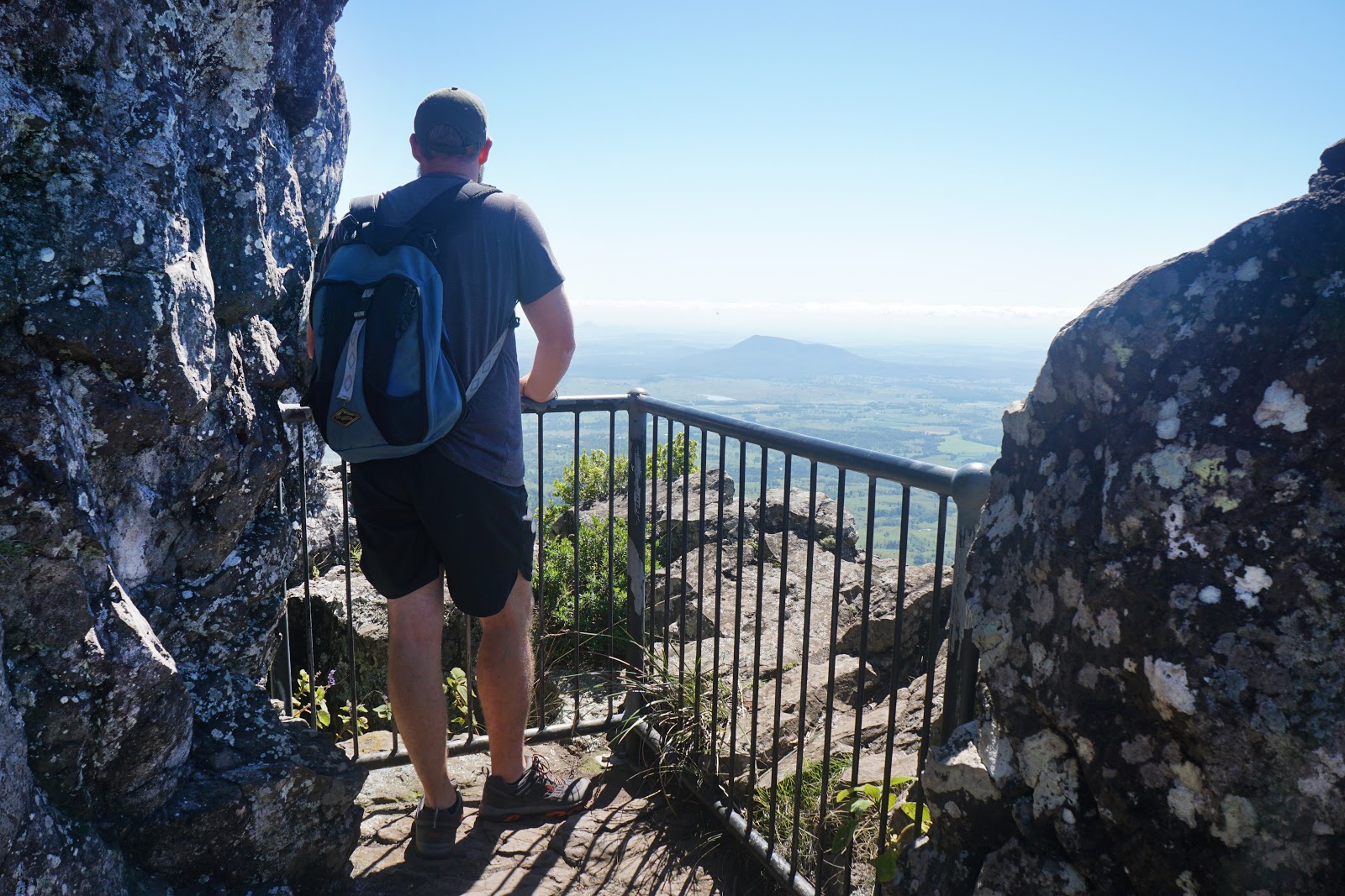
With such astounding views, it was great to see that the trail featured even more lookout points all along the ascent.

From the penultimate lookout, we could see Lake Moogerah and the mountains that make up Moogerah Peaks National Park. Again, with more time I would have loved to have tackled Mt Greville, however that just means I'll have to come back to this region sometime in the future to complete my unfinished business.
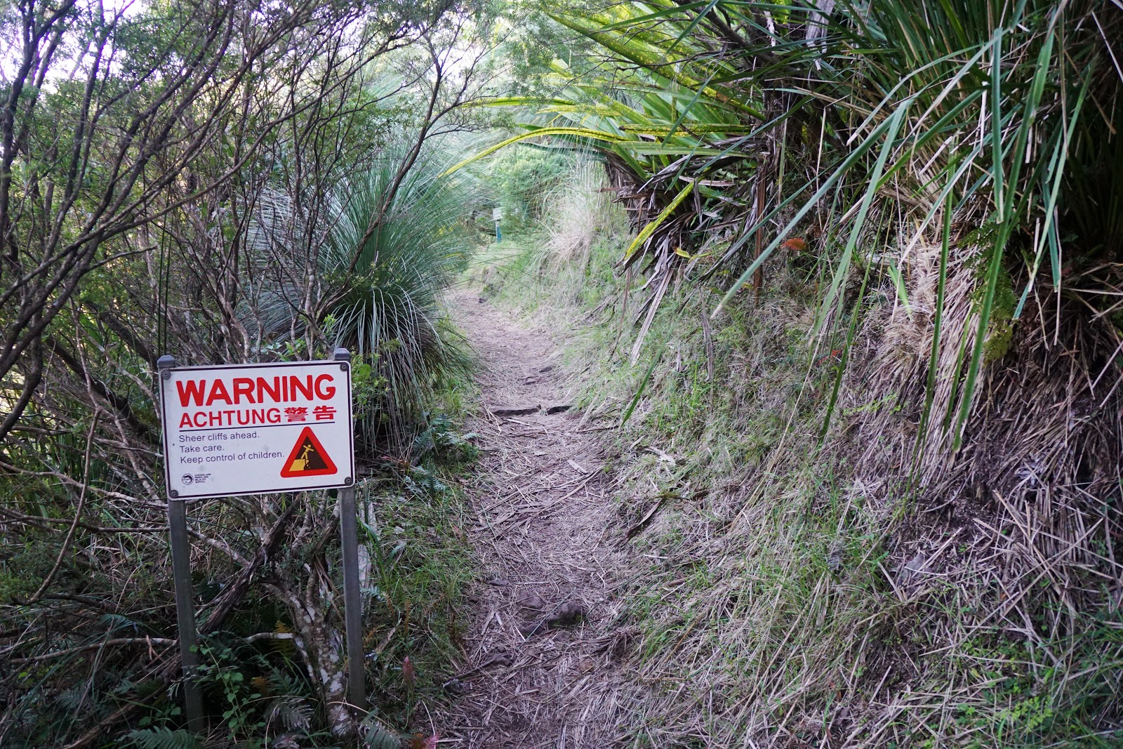
The final part of the ascent finds the trail punch through the rainforest and into grassy scrub. This section also featured a number of steep drop offs along the cliffs, hence the appearance of a warning sign.

Not long after the sign is the trail junction with the Bare Rock Track and the Mt Cordeaux lookout. Wanting to tackle the lookout first, we took the right turn up the short set of steps.

Walking up the steps, the steep blade-like pinnacle of Mt Cordeaux came into view. Looking for our way up to the summit, we realised that this was actually the end of the trail and that there is no track going all the way up the steep peak. As a mild peak bagging enthusiast I was a little disappointed but the somewhat unstable looking rocks and the sheer drop offs made it pretty clear why the lookout point is the end of the trail.

It didn't much matter anyway; there were some seriously spectacular views from the lookout point of the surrounding landscape that we were well and truly satisfied.

Descending from the summit and having smashed the Mt Cordeaux Track out in pretty good time, the three of us continued along the ridge towards Bare Rock. The first bit of the track near Mt Cordeaux features exposed views of the mountain ridge and the other side of Mt Cordeaux.

The dryer landscape up along the open ridge reminded me a lot more of what you might expect to see in somewhere like the Perth Hills. With the more open landscape came increasing warmth, and a group of hikers heading down the mountain warned us that they had seen a number of snakes. Having walked with a lot of snakes along the Bibbulmun, I was fairly unfazed however Simon became a lot more cautious for here on in.

Thankfully the trail descends slightly back into the rainforest, which provided nice and shaded walking for the next 2 kilometres of the track.

Just before reach Bare Rock, the trail reaches a junction with an optional side trip to Morgan's Walk. With Bare Rock being more of a main priority, we decided to continue onwards and check out Morgan's Walk on the way back.

The walk up to Bare Rock is fairly easy apart from a rugged section towards the end. Online information and printed signage refer to this last bit as a 'scramble' but its really not particularly complicated or technical walking at all.

Once again, the expansive views east from Bare Rock were well worth the effort. While somewhat was similar to what we had seen at Mt Cordeaux, I appreciated that we also got see other features of the landscape.

With plenty of time to kill and a decision made to have lunch in a town on the way back to the Gold Coast, we made our way back along the ridge. On the way, we stopped into Morgan's Walk. After the expansive views from Mt Cordeaux and Bare Rock, Morgan's Walk was a bit disappointing and the surrounding montane heath was just not as interesting as the montane heath that grows in other mountain ranges like the Stirling Range back home in Western Australia or the other Main Range in Kosciuszko National Park.

The walk back along the ridge was pleasant rainforest walking. With the temperature warming up, we really appreciated the shade of the trees. That's another great aspect of walking in South East Queensland - while it may be hot, the trails are often shaded enough and the fire risk low enough that you can practically keep walking all year.

As we reached the end of the Bare Rock Track, we had one final view of the other side of Mt Cordeaux before beginning our descent of the mountain, which was a fairly straightforward task given we simply retraced our steps back to the car park.


0 comments:
Post a Comment