

A sectional day hike on the Bibbulmun Track, this stretch of the track runs along the Murray River. Initially leading walkers to the beautiful campsite at Dookanelly, the track follows a new alignment as it crosses the Murray River over a purpose-built suspension bridge. Continuing along old vehicle tracks through lovely forest with excellent river views, this is a very pleasant section of the Bibbulmun Track.
Distance: 18.8 km (one way)
Gradient: A few gradual ascent and descents, but mostly on flat and gentle terrain
Quality of Path: Largely clear and well maintained. Some very deeply rutted vehicle tracks with deep puddles in Winter.
Quality of Signage: Largely well signed, with the Waugal providing very clear directional information.
Experience Required: Previous Bushwalking Experience Recommended
Time: 5 Hours, including lunch break
Steps: Some minor steps
Best Time to Visit: Late Autumn-Early Spring
Entry Fee: No
Getting There: Driver Rd is reached via Nanga Rd - east of Dwellingup off Pinjarra-Williams Rd. Head down Nanga Rd to a T Junction with Driver Rd, then take Driver Rd eastwards to a low river crossing. The Driver Rd access point is 200 metres up the road from the river crossing. The crossing can be impassible during heavy winter rains. Harvey-Quindanning Rd can also be reached from Pinjarra-Williams Rd. From Dwellingup, head east along Pinjarra-Williams Rd to Lower Hotham Rd. Continue to Lower Hotham Rd, then turn right at the end of the road onto Harvey-Quindanning Rd. The Bibbulmun Track crossing is approximately 19.6 kilometres down the road. You can also drive from Harvey-Quindanning Rd to Driver Rd. The recommended route is Harvey-Quindanning, Right Dupont Rd, Right Nanga Rd, Right Driver Rd - be careful of Google Map suggestions as it can recommend taking deeply rutted 4WD tracks suitably for high clearance vehicles only.Entry Fee: No

After our comedy of errors and poor weather the previous weekend, Alissa and I returned to Lane Poole Reserve to complete a particularly special day walk on the Bibbulmun Track - Driver Rd to Harvey-Quindanning Rd via Dookanelly campsite. Prior to 2015, the day of walking heading south from Dookanelly was famous for featuring the Long Gully Bridge - a 128 metre long wooden railway trestle bridge with significant heritage value. Sadly, the Long Gully Bridge was completely destroyed by bushfires in February 2015, and it is one of my greatest regrets as a hiker that I never got a chance to see the bridge in person. The loss of the bridge was a major catalyst for Alissa and I deciding to undertake our sectional End to End of the Bibbulmun Track and the subsequent creation of the Long Way's Better. As such, the opening of a new bridge over the Murray River had special significance, and we endeavoured to complete this newy realigned section of the track only a few weeks after its opening was announced.
After dropping off our first car at Harvey-Quindanning Rd, Alissa and I drove to our start point at Driver Rd only to discover the Driver Rd crossing was completely under water! We'd driven over the low bridge just a week earlier, however a week of solid rain had flooded out the crossing and we did not dare drive the X-Trail across the swiftly flowing water for fear of getting water in our engine. We were however determined to do this section today, and after methodically testing how strong the current was decided to slowly and cautiously walk across to the other side.

Alissa and I have done a few river and inlet crossings before, with a chest deep crossing of a fast flowing Torbay Inlet in 2012 being one of the most memorable (sadly pre-blog). Although only knee deep, the Driver Rd crossing was much more nerve-wracking as the current was probably just a few notches below being dangerously strong. Every time our sticks were in the water they would vibrate wildly due to the current, emitting a low frequency whirring sound that was rather disconcerting. Thankfully the rough and grippy surface of the crossing prevented it from being slippery, and it gave us enough of a firm anchoring to slowly battle our way to the other side. If the surface had been smooth or covered in algae, or if our shoes were heavily worn, I don't think we would have made it. Given that river crossings can be dangerous business, I would advise people to NOT undertake such a crossing unless they are very experienced and confident hikers - and even then your really need to use your own judgement as to whether the crossing is achievable or not.

With my brand new hiking boots well and truly christened by the river crossing, Alissa and I squelched our way a short distance up the road before reaching the Bibbulmun Track crossing as it heads towards Dookanelly. Alissa and I had walked this section of the track earlier in the year when we performed trail magic for our friend Michelle from Walking Two by Two by bring cold beers and cooking up some burgers for her and another hiker. Mostly travelling on heavily rutted old vehicle tracks, the fact this part of the forest was not burnt by bushfire makes for some pleasant and very enjoyable forest walking.

The walk initially heads up a very gentle incline before reaching a crest. At this point, a sign nailed to a tree kindly informs hikers that the rest of the walk to Dookanelly will be all downhill from there.

After following old vehicle tracks for most of the 3.6 kilometres from Driver Rd to Dookanelly, the home stretch runs along purpose built walk track through more pleasant Jarrah forest.

Nestled in the forest, Dookanelly is quite a lovely spot for a campsite, with some nice landscaping around the hut. Upon our arrival, Alissa and I were disappointed to see the overfilled fire pit still smoldering unattended. Reading the hut's red book, we learnt that two car campers had driven into the campsite late at night and partied until around 2 am. A hiker from Tasmania doing North Bannister to Albany was disgusted by their behaviour, and Alissa and I don't blame her!

Although quite early in the day's kilometres, the time was about right for lunch, so we had a quick bite to eat while enjoying the forest views from the hut's table.

After getting some water to put out the smoldering fire pit, Alissa and I made our way downhill to the junction between the old track and the new alignment. During the planning for the replacement of the Long Gully Bridge, a decision was made to build the replacement bridge in a new location. Due to this, the Bibbulmun follows a completely different route from Dookanelly all the way to Harvey-Quindanning Rd than it did before the 2015 fires.

Although most of the walk is through Jarrah forest, the new alignment to the bridge skirts the boundary fence of a private property for most of its distance. The cleared land is not particularly scenic, but I suppose this route was chosen for the sake of expedience.

Our friend Didier walked this section a few weeks before us, and had commented that the bridge is a lot closer than one would expect. Probably the longest and grandest suspension bridge on the track, Alissa and I actually met the engineer who designed it when we did Lake Maringup to Dog Pool earlier this year. While taking photos of the bridge, Alissa and I realised that we were standing on an ant hill and Alissa ended up dropping her sticks and dusting the attacking ants off her legs. Wearing shorts, I was glad to miraculously get out of it unscathed!
Suspension Bridge over the Murray River on the Bibbulmun Track. - Spherical Image - RICOH THETA
The bridge provides fine views over the Murray River. While it will never replace the heritage value of the Long Gully Bridge, I do think this suspension bridge will become something of an iconic landmark along this stretch of the track.

Once on the other side of the river, the Bibbulmun largely follows old vehicle tracks all the way to Harvey-Quindanning Rd. Regular readers will note that I'm not a big fan of long stretches of walking along vehicle tracks (Marron Rd is my most hated part of the Bibbulmun Track), however I think this new route is a case of making the best out of the options available and I commend the planners for their efforts. While some of the trees have blackened bark from controlled burns and/or bushfires from years ago, the forest along this side of the Murray does not have the same boredom-inducing bleakness as the forests between Yarragil Form and Murray campsite.

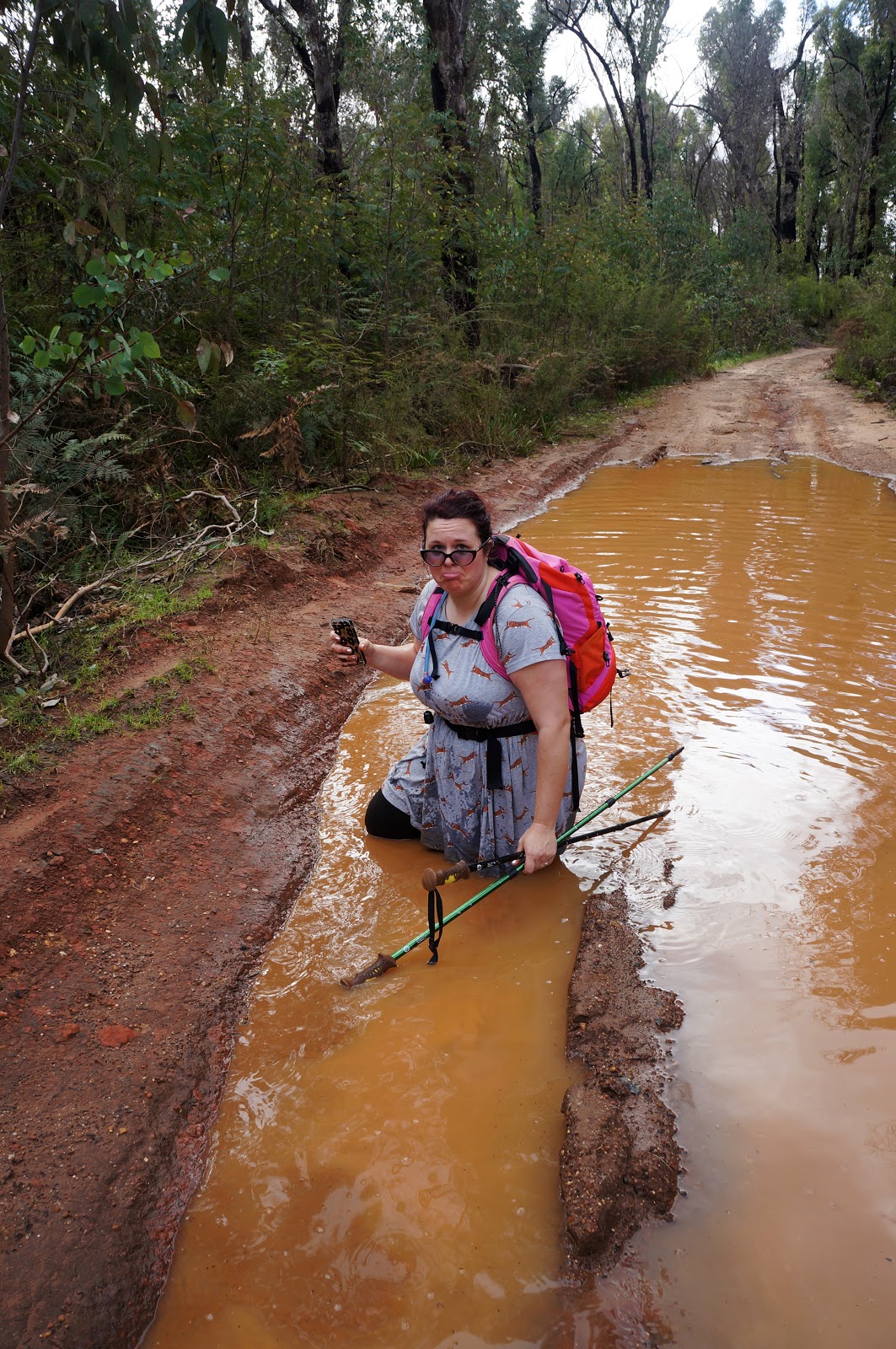
The only downside of this new route is that it is filled with deep puddles that will be seasonally inundated over winter. Initially, Alissa and I went to great pains to walk around them however after Alissa slipped and fell into one of the puddles we agreed to just embrace them; our shoes were already soggy and wet from the Driver Rd crossing, so we just walked right through them if there was not much space along the edge to walk around.

The lush Jarrah forests along the vehicle tracks had strong similarities to the Bibbulmun Track between Swamp Oak and Yarragil Form. At the time of walking, the wildflowers were just beginning to bloom but I can imagine this area being profuse with flowers just a few weeks later.

Many of the vehicle tracks along this stretch of the Bibbulmun are also used by 4WDs, and some of the ruts are so insanely deep that I can imagine that even some high clearance vehicles would struggle to make it through. Walking around the edge of the puddle to the right in the picture above, Alissa stuck her trekking pole into the puddle to see how deep it was and we were amazed to discover it was more much more than knee deep. On the topic of 4WDs - walkers should be aware that the vehicle track is also marked as a 4WD track that has superficially similar markers to the Bibbulmun. As such, it is important to look at all markers carefully to ensure you're following the right route.

After branching off from the marked 4WD track, the Bibbulmun heads down towards the river. Straight ahead, the track reaches a Summer ford while the Bibbulmun continues on to the right.

The Bibbulmun Track sometimes has a tendency of running parallel to a river without actually offering regular river views. This is a problem I've noted along the Warren River between Warren and Schafer huts, as well as along the Gardner River between Northcliffe and Gardner. As such, I was glad to find that the track had frequent river views as it made for a very enjoyable walking experience.

Being close to the river, this section featured the longest of all the puddles we would encounter over the day. Thankfully it was not very deep, and we were able to walk right through the middle without much difficulty.

Given that this section of the Bibbulmun Track is a recent reroute, Alissa and I were surprised to find that there was a section of single file walk track freshly cut just for Bibbulmun Track walkers!
"At junction, turn left onto walk trail," I said to Alissa, emulating the phraseology of the Bibbulmun Track guidebooks. Along this stretch of the track, we ran into a solo female hiker doing a thru-hike. We had a good chat with her, and would later find out that she goes by the name Dragonfly Annie and is the wife of Jacko Vanderbijl. Jacko is something of a Bibbulmun Track character, as he and Annie run Casa Libelula - a bed and breakfast in Denmark - as well as operating the most reliable shuttle service around the Wilson Inlet.

Coming out the other end of the walk trail and back onto the vehicle track, it became clear why they had put the effort into constructing the short section of single file walk trail for the new alignment - it avoided a very steep stretch of vehicle track. Alissa and I were very grateful for this; while I don't mind inclines (and enjoy walking up mountains), they can be very frustrating if they are unnecessary and unrewarding.

Beyond the end of the walk trail section, the Bibbulmun stays alongside the river almost continually, providing more pleasant walking and beautiful river views. This continued on for several kilometres.
While looking at a copy of the map of the new route on her phone, Alissa wasn't looking where she was going and ended up falling into another muddy puddle! At this point, Alissa and I were not far from a forestry plantation and we could hear the Worsley Alumina Conveyor Belt rumbling not far from where we were. Looking at the GPS, we realised we were walking parallel to Harvey-Quindanning Rd and were now not far from our second car.

Before reaching the car, we had to contend with some slow going through fallen trees. This area showed signs of being burnt by the fires of 2015, and with the extremely strong winds of the last week, many trees had fallen across the track. They were easy enough to climb over and through, but they did serve as a bit of 'traffic calming' when we really wanted to speed to the end.

Continuing along, Alissa and I could tell that we were heading deeper into more heavily burnt sections of forest with a much more open canopy and a dense undergrowth.

This continued on for a few kilometres and seemed to take forever. The section provides some nice views of the Murray River however, even if the view is of a landscape still recovering from devastation.

After following a narrow corridor through thick regrowth, we were relieved to finally reach the Harvey-Quindanning Rd crossing and our second car. From there it was a short drive back to Driver Rd to collect the X-Trail before driving home via Dwellingup.
Alissa and I agreed that Driver Rd to Harvey-Quindanning Rd had been really enjoyable section of the Bibbulmun. Although the new alignment largely follows preexisting vehicle tracks, I feel like the fact it largely passed through forest that was not badly burnt and provided excellent river views made for excellent walking. With the new bridge providing a wonderful landmark, this is a section I would be happy to walk again in the future. For the time being however, Alissa and I have our focus on our last FIVE days of walking left for us to do before we complete our sectional End to End.


Hey Don, that looks like a good section, the Bibs another one on my to do list. Ah yeah, if only work didn't get in the way! Incidentally, how did taking a photo of Alissa falling in the puddle go? I think I'd be heading for the divorce court if I tried that with Sam;) Cheers Kevin
ReplyDeleteConsidering this is a realignment, I think they've done a really good job at making it a nice day of walk on the track. Totally agree with you regarding work - if not for work we would have done our End to End in one go rather than in bits and pieces.
DeleteAlissa was actually receptive to me taking the photos - she just insisted that I hurry up! There are times she does get angry at me taking photos. She particularly hates me taking photos of her as she's walking up a steep ascent; even if there is nothing wrong with the photo or if she is a tiny speck in the distance, she just doesn't like it. Actually looking clumsy or comical she is somehow fine with :P