

One of the best sectional day walks of the Bibbulmun Track in the Darling Scarp, this walk leads walkers from the massive low-lying granite formation known as Sullivan Rock to Mt Cooke - the scarp's highest peak. With stunning views from the summit and across the various mountains and hills, this is one of the best day walk sections near Perth, conveniently located in easy reach from Albany Highway.
Distance: 13.2km (one way)
Gradient: Relatively flat for first half, then 3 kilometres continuously and relatively steeply uphill, a kilometre across the ridge and then 3 kilometres steeply downhill. Flat for the rest of the walk.
Quality of Path: Generally clear and well maintained. Sullivan Rock and Mt Cooke are largely made of granite - extra care must be taken in wet and slippery conditions.
Quality of Signage: Well signed, with the Waugal providing very clear directional information and some cairns across both Sullivan Rock and Mt. Cooke.
Experience Required: Bushwalking Experience Recommended. Though not overly tall, Mt. Cooke is still the highest peak of the Darling Scarp, and does have some tricky ascents and descents that would be a problem for those with known knee problems.
Time: 3.5 Hours
Steps: Some steps in places, but hardly of any significance
Best Time to Visit: Late Winter/Early Spring
Entry Fee: No
Entry Fee: No
Getting There: Access points are fairly easy to locate along Albany Hwy. Sullivan Rock is 9km from Jarrahdale Rd with a car park and picnic area on the western side of the highway. The second exit point we used was at Powerline Rd - easily identified by the large powerlines running overhead. You cannot drive down Powerline Rd, but it is an easy road to identify when on the track - just follow the powerlines after the Bibbulmun Track turn off until you reach the highway.

Let's be honest - although the Bibbulmun Track refers to the northernmost section of the track as being in the Darling Range, it is really an escarpment with its peaks paling in comparison to the Stirling Ranges and many of the mountain ranges in the north of the state (and they all pale compared to peaks over east). In spite of the Track's slightly misleading nomenclature, the section of the track that runs parallel to Albany Hwy traverses a number of interesting granite peaks in the Monadnocks Conservation Park. Mt Cooke, the highest of these at 582 metres above sea level, is the highest point of the Darling Scarp, and can be easily accessed as a sectional day walk on the Bibbulmun Track from the equally notable Sullivan Rock.

From the Sullivan Rock car park on Albany Hwy, a spur trail on the other side of the road takes walkers across this massive, low lying granite rock formation. A number of cairns along the rock guide walkers in the right direction, passing patches of moss and the odd Gnamma. This was a great start to the walk, and this spur would be well worth checking out by Thru-Hikers who would otherwise not need to use the access point.


The exit from Sullivan Rock to the Bibbulmun Track proper is to the left of the rock, and immediately joins the Bibbulmun at an old vehicle track. Follow the track right as it gradually descends - going left will take you to two other Monadnocks covered in a different day walk section.

The first few kilometres of the walk are fairly easy as the track traverses low-lying Jarrah forest and some slightly swampy sections. The area near Mt Cooke suffered a severe bushfire in 2003, with the fire burning so ferociously that the entire overstorey of forest was completely killed in some sections with the scrappy, thin trees currently visible being a result of this terrible fire as well as the ravages of Dieback. The most interesting sight in this section is the discarded shell of an old car parked upside down on the side of the track.

Walkers doing this section will encounter an unusual campsite - the Mt Cooke Group Campsite. Due to the popularity of this section and its close proximity to Albany Hwy, the Bibbulmun Track have provided an additional campsite for the use of school and scout groups. Unlike the Bibbulmun Track huts, the Group sites feature slightly more impressive toilets but a more spartan, larger shelter and more tent sites for students to learn outdoor skills.

Although the Group Campsite is a good place to stop over for a toilet break, walkers should note that the Mt Cooke campsite is a very short distance further down the track. The hut here is one of the larger style huts seen in the north, and also has two rainwater tanks to meet demand.

Near a boot cleaning station just beyond the hut, walkers can see the old water tank of the original Mt. Cooke Hut - the only remnant of the original hut that was burnt down in the 2003 fire. A information panel nearby provides walkers with more information, with photos of the fire sweeping up Mt. Cooke.

The track ascends almost immediately after the campsite, following a natural curve in the land as it circles up to reach the summit. Some sections here are steep and strenuous.

Although we set out for this walk with light showers and dark, foreboding clouds, we were very lucky to find clear skies as we reached the beginnings of Mt Cooke's peak. Although not exceptionally tall at 582 metres, Mt Cooke can often be covered in cloud, and I've seen many photos of the poor visibility that can occur.

The actual summit of Mt Cooke is marked by a large cairn and a metal stake. Surrounded by many tall granite boulders, this is actually one of the least impressive spots on Mt Cooke, and we found that the ridge immediately after had some of the best and most impressive views and walking.


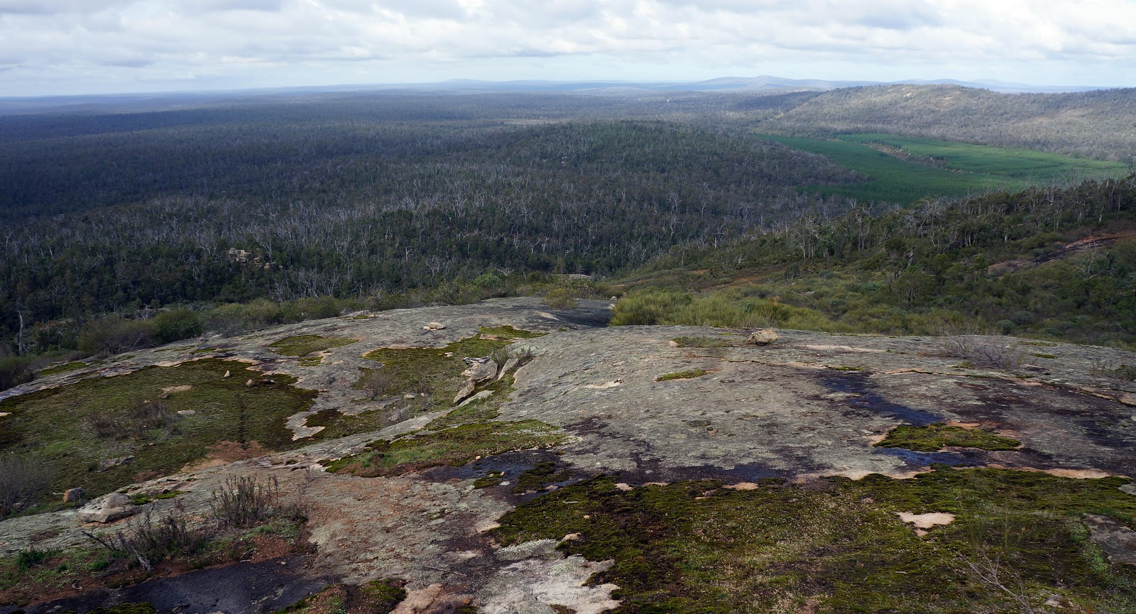
The walk across the ridge to the slightly lower second peak of Mt Cooke has some of the most impressive walking in the Darling Scarp, with 360° views of the forests and surrounding peaks as well as the interesting formations on Mt Cooke itself.


After a relatively easy going walk across the ridge, the track eventually descends. The first part of the descent is fairly steep, and I would suggest that climbing Mt Cooke in the other direction would be a lot tougher. Initially winding its way through trees and shrubs, the track eventually becomes clear, following a granite slope to the bottom with beautiful views south.

The descent is well marked by cairns and should prove easy to navigate. Again, we were very lucky to have decent weather while on the mountain, but I would imagine this slope being a bit slippery after a significant downpour.

On the way down, we looked for the famous cave but could not locate it. Based on the hollowed out formations of the rocks in this area, we were however not all all surprised that a cave would be located nearby. Oh well - just another reason for us to walk Mt. Cooke a second time.

After passing through some scrappy Jarrah forest, the track turns right onto Powerline Rd. The track eventually continues, turning left and back parallel to Albany Hwy, however day walkers following this sectional hike will want to continue on Powerline Rd as it will lead to your second car parked along the highway.
Although a fair bit of the walk passes through scrappy,thin Jarrah woodlands, walking across Sullivan Rock and climbing the summit of Mt Cooke makes this section entirely worthwhile. While not overly tall, reaching the summit can still fill walkers with a good sense of achievement, and the ridge across the top of the mountain features some of the best views and best walking in the entire Darling Scarp. This is a section Alissa and I would definitely walk again, and a good training ground for more serious mountain walking elsewhere in Australia.

Let's be honest - although the Bibbulmun Track refers to the northernmost section of the track as being in the Darling Range, it is really an escarpment with its peaks paling in comparison to the Stirling Ranges and many of the mountain ranges in the north of the state (and they all pale compared to peaks over east). In spite of the Track's slightly misleading nomenclature, the section of the track that runs parallel to Albany Hwy traverses a number of interesting granite peaks in the Monadnocks Conservation Park. Mt Cooke, the highest of these at 582 metres above sea level, is the highest point of the Darling Scarp, and can be easily accessed as a sectional day walk on the Bibbulmun Track from the equally notable Sullivan Rock.

From the Sullivan Rock car park on Albany Hwy, a spur trail on the other side of the road takes walkers across this massive, low lying granite rock formation. A number of cairns along the rock guide walkers in the right direction, passing patches of moss and the odd Gnamma. This was a great start to the walk, and this spur would be well worth checking out by Thru-Hikers who would otherwise not need to use the access point.


The exit from Sullivan Rock to the Bibbulmun Track proper is to the left of the rock, and immediately joins the Bibbulmun at an old vehicle track. Follow the track right as it gradually descends - going left will take you to two other Monadnocks covered in a different day walk section.

The first few kilometres of the walk are fairly easy as the track traverses low-lying Jarrah forest and some slightly swampy sections. The area near Mt Cooke suffered a severe bushfire in 2003, with the fire burning so ferociously that the entire overstorey of forest was completely killed in some sections with the scrappy, thin trees currently visible being a result of this terrible fire as well as the ravages of Dieback. The most interesting sight in this section is the discarded shell of an old car parked upside down on the side of the track.

Walkers doing this section will encounter an unusual campsite - the Mt Cooke Group Campsite. Due to the popularity of this section and its close proximity to Albany Hwy, the Bibbulmun Track have provided an additional campsite for the use of school and scout groups. Unlike the Bibbulmun Track huts, the Group sites feature slightly more impressive toilets but a more spartan, larger shelter and more tent sites for students to learn outdoor skills.

Although the Group Campsite is a good place to stop over for a toilet break, walkers should note that the Mt Cooke campsite is a very short distance further down the track. The hut here is one of the larger style huts seen in the north, and also has two rainwater tanks to meet demand.

Near a boot cleaning station just beyond the hut, walkers can see the old water tank of the original Mt. Cooke Hut - the only remnant of the original hut that was burnt down in the 2003 fire. A information panel nearby provides walkers with more information, with photos of the fire sweeping up Mt. Cooke.

The track ascends almost immediately after the campsite, following a natural curve in the land as it circles up to reach the summit. Some sections here are steep and strenuous.

Although we set out for this walk with light showers and dark, foreboding clouds, we were very lucky to find clear skies as we reached the beginnings of Mt Cooke's peak. Although not exceptionally tall at 582 metres, Mt Cooke can often be covered in cloud, and I've seen many photos of the poor visibility that can occur.

The actual summit of Mt Cooke is marked by a large cairn and a metal stake. Surrounded by many tall granite boulders, this is actually one of the least impressive spots on Mt Cooke, and we found that the ridge immediately after had some of the best and most impressive views and walking.


The walk across the ridge to the slightly lower second peak of Mt Cooke has some of the most impressive walking in the Darling Scarp, with 360° views of the forests and surrounding peaks as well as the interesting formations on Mt Cooke itself.
After a relatively easy going walk across the ridge, the track eventually descends. The first part of the descent is fairly steep, and I would suggest that climbing Mt Cooke in the other direction would be a lot tougher. Initially winding its way through trees and shrubs, the track eventually becomes clear, following a granite slope to the bottom with beautiful views south.

The descent is well marked by cairns and should prove easy to navigate. Again, we were very lucky to have decent weather while on the mountain, but I would imagine this slope being a bit slippery after a significant downpour.

On the way down, we looked for the famous cave but could not locate it. Based on the hollowed out formations of the rocks in this area, we were however not all all surprised that a cave would be located nearby. Oh well - just another reason for us to walk Mt. Cooke a second time.

After passing through some scrappy Jarrah forest, the track turns right onto Powerline Rd. The track eventually continues, turning left and back parallel to Albany Hwy, however day walkers following this sectional hike will want to continue on Powerline Rd as it will lead to your second car parked along the highway.
Although a fair bit of the walk passes through scrappy,thin Jarrah woodlands, walking across Sullivan Rock and climbing the summit of Mt Cooke makes this section entirely worthwhile. While not overly tall, reaching the summit can still fill walkers with a good sense of achievement, and the ridge across the top of the mountain features some of the best views and best walking in the entire Darling Scarp. This is a section Alissa and I would definitely walk again, and a good training ground for more serious mountain walking elsewhere in Australia.


0 comments:
Post a Comment